
Heavy Rain, Flooding, and Chance of Severe Weather Staring Down the Southern U.S.
January 22, 2024
Posted: March 28, 2023 9:30 am


An area of low pressure anchored over the state of California is producing yet another round of torrential rain, strong winds, and snow. The storm is just one of the many major systems that have hit the Golden State in recent weeks, including what was classified as a bomb cyclone last week.
The latest weather maker came together as a system from Alaska joined with a storm in the Pacific Ocean late Sunday and churned its way down the West Coast. By Tuesday, California will be firmly in the grips of this weather event.
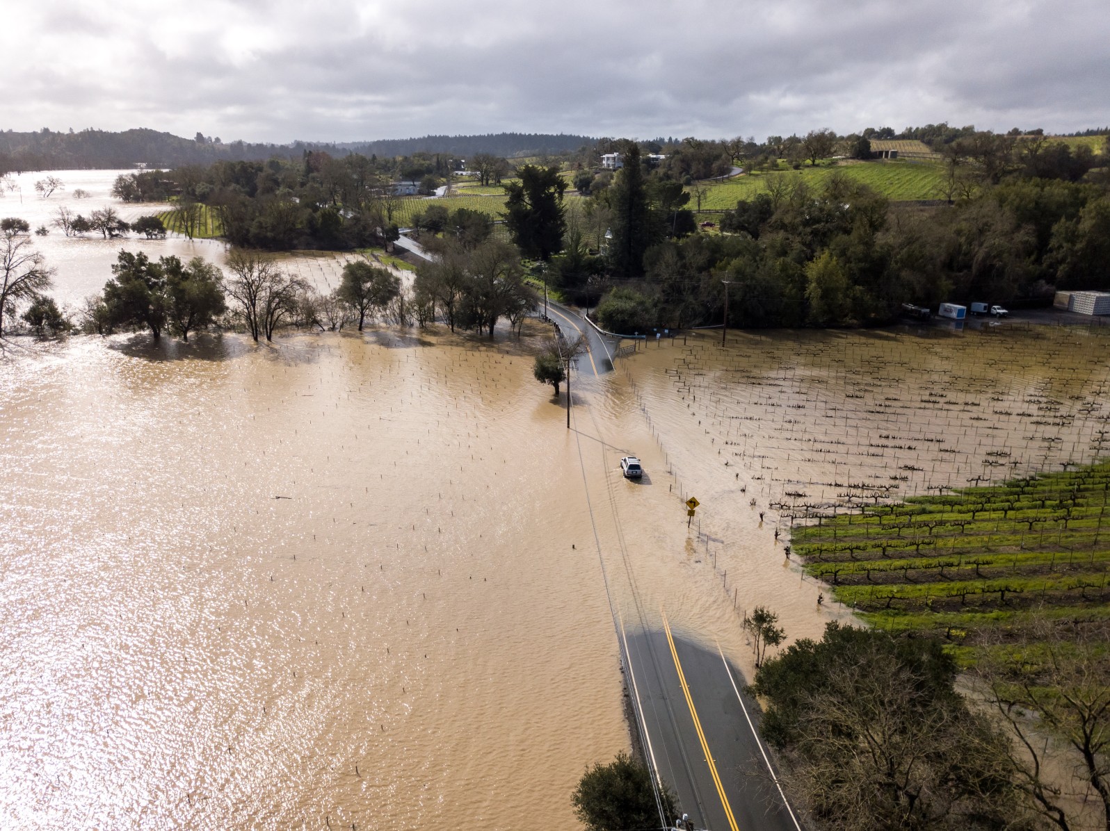
While it was the strong winds that caused the worst of the damage during last week’s bomb cyclone, forecasters warn that the greatest threat with the new storm will be freshwater flooding. Many communities are still dealing with the heavy rain from the last storm, causing mudslides and flash flooding in the central part of the state. This leftover impacts will be exacerbated with the incoming precipitation.
A widespread 1 to 2 inches of rain is expected for the San Francisco Bay Area and into the Sacramento Valley. The area to the north of the Bay Area and across the foothills of the Sierra Nevada could see rain measuring up to 4 inches, raising the risk of flooding for these communities.
Tuesday will be the wettest day of the week for California, however, you can count on the rain lingering through Wednesday and maybe even Thursday. Southern California will be spared the worst of the rain with less than an inch of new rainfall in the cards.
It has already been an exceedingly wet few months for the state. Most of California is already in the top 10 in the list of wettest winters with some areas recording moisture that is up to five times the historical average.
It has not been just rain that has been breaking records throughout California this year. The snow in the higher terrains is also trending well above normal for most areas. This trend will continue this week as the new system gears up to dump several feet of snow in the mountains.
The Sierra Nevada has been ground zero for the blockbuster snow season. For instance, the popular ski resort area of Mammoth Mountain only needs to pick 2 more inches of snow to break the record for the highest amount of the white stuff in recorded history. The single-season record for Mammoth Mountain is 668 inches with 1 to 4 feet of snow in the forecast.
This amount of snow is great news for winter sports enthusiasts who can now expect to be enjoying the conditions well into the spring and early summer. However, the new round of snow will translate to headaches for motorists heading over some of the mountain passes on interstates 5 and 80. Forecasters are warning travelers to expect closures and delays beginning late Tuesday.
The snow level may drop as low as 500 feet because of the cold air associated with this storm system. This includes potential impacts for the Grapevine in Southern California. The Transverse ranges may also see snow out of this storm.
In addition to the rain and the snow, the region needs to be prepared for strong winds and hail as the storm roars onshore. Like last week’s bomb cyclone, the Bay Area will be at risk of experiencing damaging winds in the range of 50 – 60 mph. The mountains outside of the city may clock gusts as high as 100 mph, creating the potential of blizzard conditions in areas that are also dealing with snow.
The winds will begin to die down by Wednesday and Thursday as the storm loses its strength. However, breezy conditions will linger across the Los Angeles Basin.
The greatest chance of hail will happen late Wednesday and into Thursday as bulk of the coldest temperatures in the upper atmosphere move onshore in Southern California. Residents in this heavily populated area of the state will want to stay abreast of this developing situation.
Did you find this content useful? Feel free to bookmark or to post to your timeline for reference later.

January 21, 2024

January 19, 2024

January 18, 2024
