
Heavy Rain, Flooding, and Chance of Severe Weather Staring Down the Southern U.S.
January 22, 2024
Posted: March 17, 2023 11:22 am


While it has been a dry few days for Californians, the break from the persistent rain and snow will not last long. Another robust storm is brewing in the Pacific Ocean, set to move into the state by next week. Here is the latest on the active weather pattern that has distinguished the winter for California.
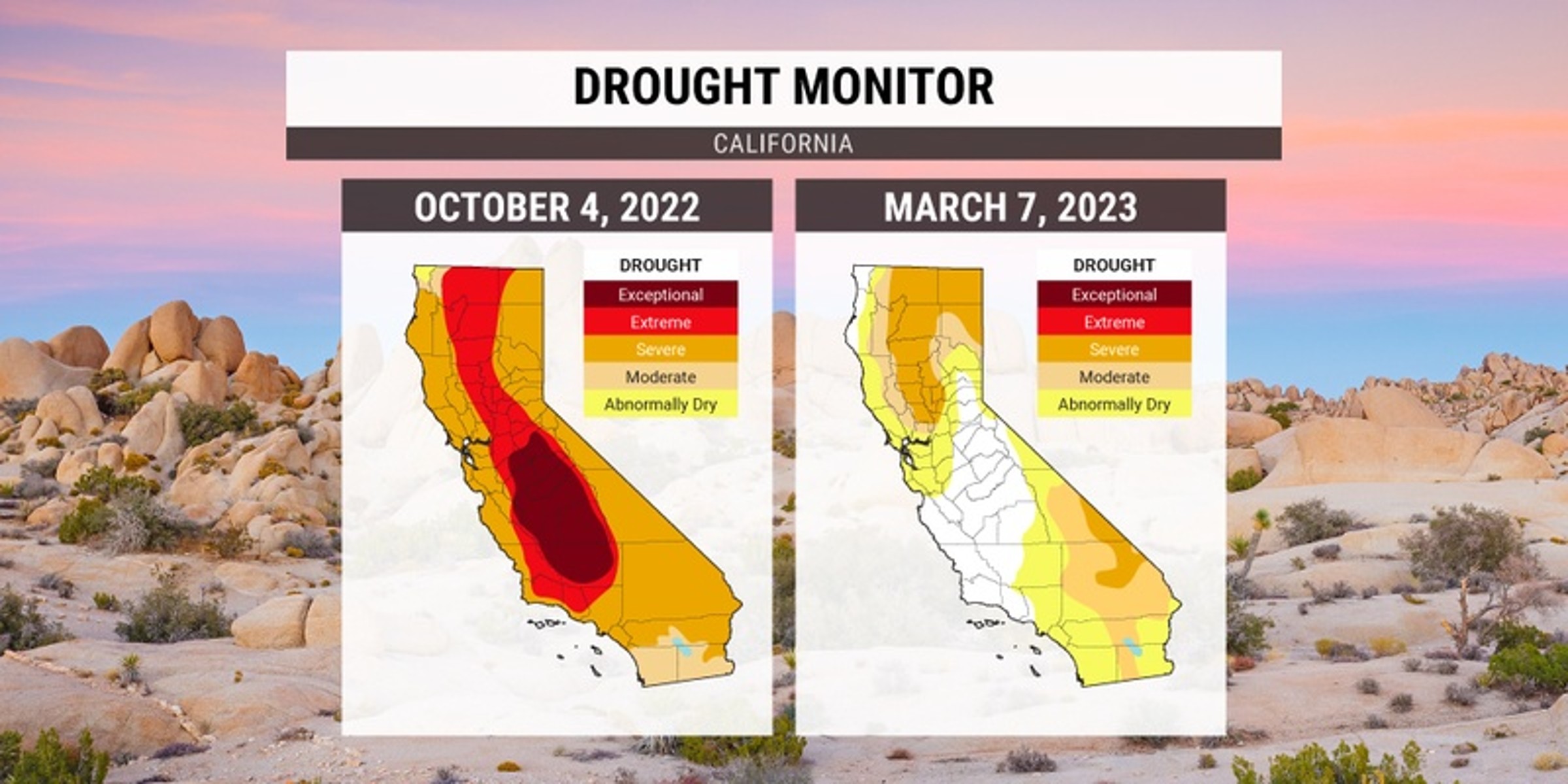
It has been a messy winter for nearly the entire state of California. A number of moisture-rich storms have roared through the Golden State over the last few months, completely eradicating the drought that had persisted for so long.
According to the last report from the U.S. Drought Monitor, nearly half of the state is either free of drought completely or just under a destination of abnormal dryness. Forecasters are predicting that the bulk of the state will be considered to be drought-free by the time the dry summer season rolls around.
The precipitation has been so intense that many of the state’s reservoirs have had to release water as levels rise above capacity. Lake Oroville and Lake Shasta are both sitting at much better levels thanks to the series of recent storms.
While the eradication of the drought is certainly a relief, the parade of storms has come with its own set of problems. The latest atmospheric river to hit the state last week brought heavy snow to the Sierra Nevada and flooding rain to Southern California. Strong winds in Northern California led to widespread power outages.
High pressure has moved into the state for the weekend, giving residents the chance to catch their breath and rivers the opportunity to recede. After a brief respite from the active weather pattern, another storm is setting up to move into the region by Monday.
This weather maker will bring in a deep plume of moisture from the Pacific, creating yet another round of flooding concerns. In addition to the rain at the lower elevations and coastal areas, the higher terrains will be hit with significant snowfall. The Sierra Nevada may come in with all-time snow totals by the end of the week should this system develop to fruition.
Mammoth Mountain has recorded over 600 inches of snow the winter. It will take a few more big storms to break the all-time record of 668.5 inches, set back in 2010 – 2011. However, forecasters caution that this record is within reach.
Colder temperatures associated with this storm may bring the snow levels as low as 4,000 feet. This is in contrast to last week’s system that featured warmer air, keeping the snow relegated to only the highest elevations.
This will bring another set of travel challenges across the many mountain passes in the area. As with the past robust storm systems, this next event will also bring the threat of mudslides and strong winds. Widespread power outages are also a possibility by Tuesday.
Looking ahead, the Golden State is forecast to dry out again by Thursday and Friday. However, this is not the time to get complacent. Forecasters are expecting another round of storms to hit the state heading into the end of March.
Did you find this content useful? Feel free to bookmark or to post to your timeline for reference later.

January 21, 2024

January 19, 2024

January 18, 2024
