
Heavy Rain, Flooding, and Chance of Severe Weather Staring Down the Southern U.S.
January 22, 2024
Posted: October 27, 2022 9:52 pm


With just over one month to go in the official Atlantic hurricane season, forecasters are being kept busy monitoring potential tropical development. Here is a look at the three areas of the Atlantic that the National Hurricane Center (NHC) is keeping a close eye on this week.
Non-tropical System Near Bermuda
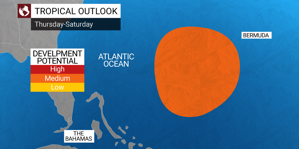
Earlier in the week, forecasters had been warning that an area of low pressure spinning north of Bermuda could evolve into a tropical storm. However, that window of opportunity for potential development has likely passed for this particular feature.
Despite the feature not taking on tropical characteristics, it will still deliver torrential rains and strong winds to much of the New England coastal area on Wednesday before setting its sights on Atlantic Canada for Thursday. Localized flooding is a good possibility because of the moisture associated with this storm system.
Although the precipitation and winds riding along in this feature will be limited to the eastern portions of New England, another system moving to the east from the Midwest will bring significant moisture to the interior Northeast. This will make for a wet middle of the week for much of the Great Lakes and Northeast.
This corner of the Atlantic basin has also spurned another system located east of the Bahamas and about 500 miles to the southwest of Bermuda. Like the system near Bermuda earlier this week, this feature could also take on tropical characteristics in the coming days.
This system has stretched over 500 miles long, expanding into the Caribbean. Forecasters are still uncertain about the odds that this feature could develop into a tropical depression or storm. There is also the chance that the system could halt its intensification and dissipate in the coming days.
The NHC said that the feature could evolve into a subtropical system that exhibits characteristics of both tropical and non-tropical features. The disturbance would need to show wind speeds around the defined area of circulation of 39 mph or greater in order to be defined as a tropical storm. A system with a defined area of circulation that does not reach this wind speed threshold would be designated as a tropical depression.
Whatever characteristics that it takes on, the system is not expected to threaten the U.S. Instead, the steering breezes are predicted to push the storm toward the northeast and out into the open seas away from the Bahamas. By the end of the week, it may be Bermuda that is under the gun for more tropical impacts, including heavy rains, thunderstorms, and rough sea conditions.
As of mid-day Wednesday, the disturbance was sending rain showers and thunderstorms to the northern coast of South America and up through Puerto Rico. The U.S. Virgin Islands are also seeing the impacts from this feature. Because the feature is not moving at a fast clip, forecasters are warning that Puerto Rico will be in the crosshairs for flash flooding and mudslides.
One last disturbance is raising red flags farther south in the Caribbean. This is the time of the year when it is not unusual for disturbances to move to the west from the Indian Ocean and off the coast of Africa. A tropical wave did indeed move from Africa toward the coast of South America last week, setting the stage for a potential named storm.
Hurricane experts say that the storm is most likely to remain disorganized in the coming days and not intensify into a named feature. However, this scenario would still produce heavy rain and winds that would spread across the southern Caribbean islands and toward Central America in the coming week.
There is also a small possibility that the system could intensify and organize while it is spinning through the warm waters of the eastern Caribbean. This scenario would produce a higher chance of significant impacts to the northern tier of the Caribbean.
Although the Caribbean tends to quiet down heading into November, it is important to remember named storms are not entirely uncommon this time of the year. The 2020 season saw two Category 4 hurricanes form in November. The next names on the list of storms this year are Lisa, Martin, and Nicole.
Did you find this content useful? Feel free to bookmark or to post to your timeline for reference later.

January 21, 2024

January 19, 2024

January 18, 2024
