
Heavy Rain, Flooding, and Chance of Severe Weather Staring Down the Southern U.S.
January 22, 2024
Posted: September 14, 2023 1:13 pm


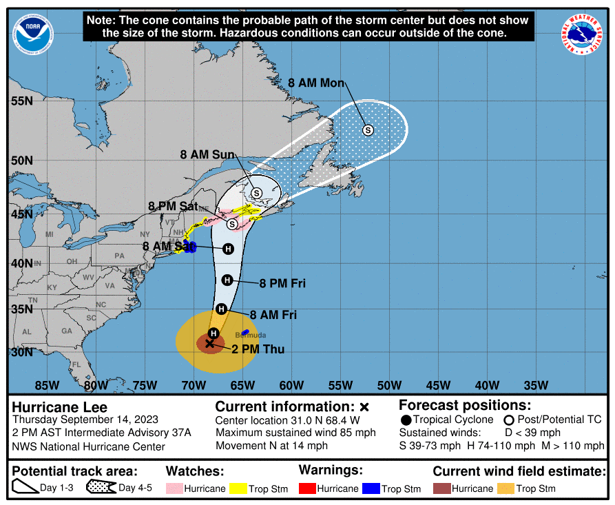
Although Hurricane Lee continues to weaken, the Category 1 storm is still set to bring significant impacts to the New England coastal areas and into Atlantic Canada. Forecasters have been able to hone in on the anticipated landfall zone of this long-lived hurricane that has been churning in the Atlantic for over a week. Here is what the latest models are indicating.
Hurricane and Tropical Storm Watches Issued
Hurricane and tropical storm watches are now in effect for a large swath of the coastline of New England. Meanwhile, rough surf conditions and dangerous rip currents stirred up by Lee are affecting the coastline to the south.
The National Hurricane Center (NHC) is warning residents of eastern New England to prepare for a potential hurricane strike as Lee is expected to approach the region late Friday and into the weekend. The latest models predict that the storm will make landfall in an area between eastern Nova Scotia to New Brunswick. There is still a small chance that the storm could make a turn earlier and hit Maine.
The last update by the NHC early Thursday puts Lee at a Category 1 storm with wind speeds of 90 mph. This has translated to tropical storm conditions for Bermuda as Lee churns about 240 miles west-southwest of the group of islands.
The storm is moving at a faster clip, heading to the north at 14 mph. This compares to earlier in the week when the system was crawling to the west-northwest at a snail’s pace of 3 – 6 mph.
Despite being about 750 miles from Nantucket, Massachusetts, Lee was already churning up seas up and down the East Coast. The sheer size of Lee means that the hurricane-force winds are reaching 90 miles from the center of the storm while the tropical-storm-force winds are extending about 300 miles
Even if the storm remains to the east of the coast of Massachusetts, this part of the Eastern Seaboard will likely see strong winds and heavy rains as it moves to the northeast this weekend. The high swells will reach as far south as the upper mid-Atlantic coastline by Friday, generating rough surf conditions.
Rain and Wind Predictions
Wind speeds are expected to build in eastern New England and the Canadian Maritimes throughout the weekend. The winds will be high enough to create power outages and damage to trees.
Cape Cod, Massachusetts will be in the bullseye of these impacts late Friday and into Saturday. Forecasters warn that the storm will feel like a nor’easter for the bulk of Cape Cod Bay and beyond. The north-facing coast of Massachusetts and the south-facing zone of the Canadian Maritimes are forecast to see a storm surge of 3 – 6 feet as the strong winds push the ocean water onto land.

The good news is that Lee is coming into an area of cooler waters as it tracks to the north, supporting its eventual weakening. It is possible that the storm will not even be an official hurricane by the time that it makes its landfall. The weather maker is forecast to weaken considerably, hitting the status of a tropical rainstorm, shortly after landfall. The current projections have Lee making landfall late Saturday night.
The timing of Lee’s arrival could also complicate the situation. The high tide cycles beginning Friday night and into Saturday could present issues for the coastline from Massachusetts and up through southern Maine. The Bay of Fundy between the Canadian provinces of New Brunswick and Nova Scotia will see an even higher amount of storm surge.
Lee’s increasing speed will mean that rainfall amounts will be mitigated as the storm is not expected to stall over any particular area. However, flooding is still a risk as much of this region has already seen significant amounts of rain over the last several days. It will not take a lot of rain from Lee to create the risk of flash flooding in Maine, New Brunswick, and Nova Scotia.
How much rain will the region see? The forecast is calling for widespread rainfall amounts of 2 – 4 inches with localized pockets of 4 – 8 inches.
As is typical with tropical features, the highest winds will spin around to the south and east of the center of the storm. Gusts will hit as high as 60 to 80 mph in central and coastal Maine with higher speeds likely in the Canadian Maritimes. The top wind speeds are forecast for the Bay of Fundy region and into southern Nova Scotia. Power outages will be a concern for eastern Massachusetts and up through New Hampshire, Maine, and into Atlantic Canada.
Lee’s Impacts to Bermuda and Beyond
The storm will not just bring hazards to New England and Atlantic Canada. Rough surf conditions are already being reported along the Eastern Seaboard of the U.S. as Lee nears closer. Life-threatening rip currents will be an issue over the next few days. Minor coastal flooding and beach erosion may also be the storyline this weekend for the mid-Atlantic coastline.
Lee is forecast to move within 100 miles to the west of Bermuda. The island nation began to experience tropical-storm-force winds on Thursday morning.
The NHC is also closely monitoring the potential formation of a new named storm as a disturbance picks up steam near the Cabo Verde Islands. This could be the next feature to pose a threat to the Caribbean and the U.S. Exceptionally warm sea surface temperatures and the absence of significant amounts of wind shear will be the driving forces supporting the development of this storm system.
Bermuda could see the impacts from this budding system by the middle of next week. Should the disturbance take on tropical characteristics, it would be called Nigel. It is too early to tell if the storm will take a turn to the north and remain well out to sea or if it will track in a westerly direction and threaten the U.S. East Coast.
Did you find this content useful? Feel free to bookmark or to post to your timeline for reference later.

January 21, 2024

January 19, 2024

January 18, 2024
