
Heavy Rain, Flooding, and Chance of Severe Weather Staring Down the Southern U.S.
January 22, 2024
Posted: October 6, 2023 1:42 pm


It is going to go from feeling like summer to fall in a matter of hours across the Great Lakes and the Northeast. Prior to the drop in temperatures, a surge of moisture will create the risk of flash flooding and possibly even snow in the higher elevations. Here is what you need to know about this dynamic forecast.
Wet and Potentially Stormy Conditions for the Northeast
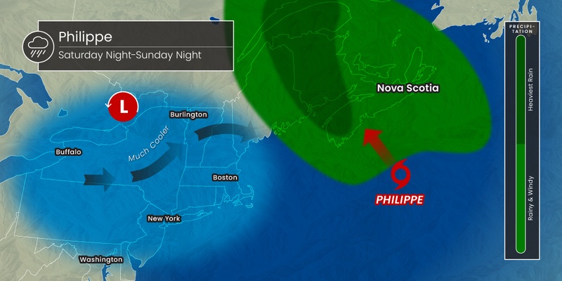
The arrival of Tropical Storm Philippe will first begin to impact the Northeast by the weekend, bringing the chance of heavy rain and flash flooding to this part of the country. This influx of tropical moisture will meet with another front coming from the Midwest to create messy conditions beginning on Friday.
The rain showers and thunderstorms riding just ahead of a powerful cold front will first fire up across the eastern Great Lakes and into the central Appalachians by the end of the work week. This moisture and severe weather will drop as far south as the mid-Atlantic while extending as far north as southern New England.
Localized urban flash flooding will be a concern for the Northeast heading into the weekend. This situation could worsen as Philippe inches closer as it makes its approach from the central Atlantic basin. The current models forecast that Philippe will make landfall near the border of Nova Scotia and Maine late this weekend. This means that the northeastern corner of New England is likely to see the heaviest rain bands.
A stretch of land from Long Island and up into New England is predicted to see rainfall amounts of 2 – 4 inches starting late this weekend and heading into early next week. The greatest threat of flooding will be in areas that saw the heavy rain last week. This is because the grounds are still saturated, making it more difficult to absorb any new moisture.
Much Cooler Temperatures Will Trail Moisture
Cold temperatures will filter in behind this rain, slashing the mercury by 20 to 30 degrees. It was an unseasonably warm week for much of the Midwest and the Northeast, meaning that this temperature change will feel even more dramatic.
Daytime highs will top out in the 40s across the Appalachians while the interior Northeast will struggle to hit the 60-degree mark. The historical norm for the first weekend in October ranges from the high 50s in the Upper Midwest and Northeast to the low 70s in the Ohio River Valley and northern mid-Atlantic region.
Forecasters are also predicting a good chance of lake-effect rain showers across the Great Lakes. This lake-effect precipitation takes root when the water is warmer than the air temperatures, helping clouds to build and moisture to form. Some of these rain clouds could create thunderstorms over the region.
This weather pattern will also raise the risk of waterspouts across lakes Michigan, Erie, and Ontario. The highest risk of waterspout formation will be on Sunday and Monday. The lakes will also be susceptible to overwash this weekend thanks to the stiff winds swirling over the water.
Breezy Conditions Will Create Chillier Real Feel Readings
Cool winds will bring the real feel temperature down even further, particularly around and downwind from the Great Lakes region. This means that real feel temperatures could plummet as low as the 30s over the higher terrains.
The cold air will be enough to support the development of wet snow across some of the highest terrains of the Adirondack Mountains late this weekend. The forecast in northeastern New York state is calling for 1 to 3 inches of snow accumulating on grassy areas and elevated surfaces.
The thick cloud cover and breezy conditions will keep the overnight lows from falling as dramatically. Temperatures tend to fall lower under clear skies and less wind. As a result, widespread frost conditions are not on the horizon for this weekend in the Northeast.
The areas most likely to see the chance of frost will be across Iowa, Missouri, South Dakota, and Wisconsin. Overnight temperatures will also fall below freezing on Friday night and into Saturday across the western portions of Nebraska, the Dakotas, Kansas, and the Plains of Wyoming and Colorado.
What to Expect for Overnight Lows Elsewhere
The lowest readings will be along the coastal portions of the Northeast and back into the Ohio Valley and central and northern Plains states. This part of the country will see clearer skies and not as much wind, helping to nudge the mercury down to the lowest readings of the season thus far.
For instance, Chicago is forecast to see overnight lows that fall into the mid 40s this weekend and into the early part of next week. It has not been this cold in the Windy City since the middle of May. Lows will also likely fall into the 40s in New York City, a benchmark not seen since late spring.
The chill in the air will hang on for several days, lasting through the majority of the next week for the Great Lakes and the Northeast. You can expect the temperatures to rebound earlier in the Plains states and the Ohio Valley.
Did you find this content useful? Feel free to bookmark or to post to your timeline for reference later.

January 21, 2024

January 19, 2024

January 18, 2024
