Heavy Rain, Flooding, and Chance of Severe Weather Staring Down the Southern U.S.
January 22, 2024
Posted: June 1, 2023 1:53 pm


A change is on the way for the Northeast, sending the temperatures crashing and bringing in the chance of rain to the parched region.
It has felt more like the middle of summer this week for the Northeast, however, a dramatic cooldown is on tap for the weekend. Here is the latest on this roller coaster of a forecast.
The mercury will continue its upward trajectory through Friday before the next round of cool air arrives. The change in the weather pattern will also usher in the chance of thunderstorms but forecasters warn that the moisture will not be enough to help to ease the ongoing dryness and drought.
The position of the jet stream this week has paved the way for warmer than average temperatures for the Northeast and Midwest this week as well as unseasonably cool readings for the Southeast. This warmth will remain in place over the Northeast on Thursday and Friday with many areas hitting the 90-degree benchmark.
The strong June sunshine will send the real feel temperatures even higher. Because of the ongoing dry conditions, the heat provided by the sun is able to penetrate the air at higher rates because it is not pulling moisture out of the ground.
Record high temperatures may be a possibility on Friday for the northern tier of New England. This includes readings well into the 90s in northern Maine and throughout upstate New York.
The heat will track to the south by Friday, bringing the hot weather into the mid-Atlantic. New York City, Philadelphia, and Washington, D.C. will all see the mercury approach the 90-degree mark.
Most daily high records for this part of the county hover in the mid to upper 90s, putting these records likely out of reach this time around.

The heat is going to come to a crashing halt by the end of the week at the hands of the arrival of a cold front. This front will move to the southwest over the next few days, spreading from New England into the mid-Atlantic states.
You can expect daily high temperatures to drop from the 80s and 90s down into the 70s and 60s as this front progresses through the region. Some areas may see the temperature fall by 15 degrees in a period of a few hours as the winds shift.
Most major cities in the Northeast will see a change of 10 – 20 degrees for high readings from Friday to Saturday. In addition, the coastal areas will be under the gun for some chilly winds. This will not be the most ideal weekend to head to the beach in the Northeast.
Along with the wind and cooler temperatures, the front will also increase the chances of gusty thunderstorms. However, the moisture associated with these storms will be spotty in nature. Any thunderstorms are predicted to be short-lived.
The stormy conditions will kick up on Friday afternoon in northern New England before moving to the southwest by Saturday. This timing means that New Jersey, New York City, Delaware, northern Virginia, and Maryland will see the chance of storms by Saturday.
It will be a good idea to stay on top of your local hourly forecast if your plans this weekend are taking you outside. Forecasters are warning that the conditions may change quickly as the front quickly sweeps through.
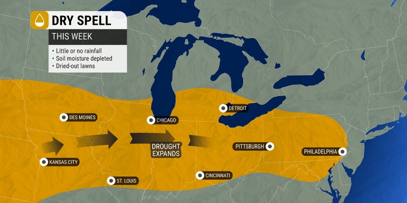
Despite the forecast of scattered storms this weekend, some areas may remain completely dry. This is not good news for a part of the country that has been increasingly dry lately.
You are not alone if your lawn is starting to brown up because of the lack of moisture. Farmers are also grappling with the ongoing dryness, particularly across Pennsylvania’s Susquehanna Valley. This portion of the interior Northeast just experienced the driest May on the record books.
For instance, while the region typically sees up to 4 inches of rain over the course of the month, most areas did not even see a half of an inch in May.
The latest data from the U.S. Drought Monitor is painting a dire picture for much of the mid-Atlantic and the central portions of the Appalachians. The lack of moisture has raised the risk of brush fires heading into the hot and dry summer months.
The sliver of hope is that the long-range forecast is predicting a return of the rain to the area by the middle of June.
Did you find this content useful? Feel free to bookmark or to post to your timeline for reference later.

January 21, 2024

January 19, 2024

January 18, 2024