
Heavy Rain, Flooding, and Chance of Severe Weather Staring Down the Southern U.S.
January 22, 2024
Posted: October 4, 2023 12:00 pm


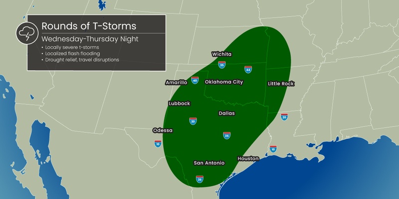
Residents of the Dallas and Fort Worth Metroplex are being warned to stay on guard for the potential of potentially dangerous flash flooding as a disruptive storm system swings into the southern Plains. Here is what you need to know if you live in the Metroplex and beyond.
Storms to Fire Up Wednesday Across Northern Texas
It has been a sweltering summer and start to fall for the Dallas metropolitan area. While the city is going to feel some relief from the heat in the coming days, this relief will come with a price. A surge of cooler air from Canada will also trigger a good chance of torrential downpours and severe weather.
The greatest threat of storms and flash flooding will be focused across north-central and northeastern Texas. This part of the Lone Star State is home to the heavily populated Metroplex.
While Wednesday will start on a calm note in the Dallas area, thunderstorms are forecast to erupt in the afternoon hours. Temperatures will remain on the warm side, topping out at about 90 degrees during the peak afternoon heating hours. Winds will be out of the south-southeast at 10 to 15 mph.
The biggest risk of storms will fire up in the evening and overnight hours. These storm cells will pack quite the punch in terms of rainfall amounts. Dallas is bracing for 1 to 2 inches of rain in the overnight hours. It will be a muggy night with high humidity levels and a low barely dropping below the 70-degree mark.
Life-Threatening Flash Flooding in the Forecast for Metroplex
Local officials are warning of the potential of life-threatening flash flooding. Motorists traveling along the portions of interstates 20, 30, 35, and 45 in and near the Metroplex will want to take caution and stay abreast of the developing situation.
Hourly rainfall amounts can top 1 inch during the height of the storms. Rainfall of this magnitude could quickly overwhelm storm drains and low-lying areas, creating serious flooding concerns.
In addition, this is a part of the region that has been dealing with drought conditions as of late. Dry ground is more likely to repel water when it falls for the first time, leading to more flooding potential. It takes some time for rain to soften the ground enough that it begins to absorb the moisture like a sponge rather than repelling it.
The forecast is calling for a general 2 to 4 inches of rain in northeastern Texas and into western Arkansas and eastern portions of Oklahoma on Wednesday and Thursday. The heaviest of the rain will fall overnight Wednesday and into Thursday morning as the storms move from west to east. Do not be surprised to see localized amounts of up to 6 inches in a period of less than 24 hours.
Travelers will want to be ready for significant delays on both the roads and in the skies. This is a good time to remind drivers to never attempt to drive into standing water. It does not take much time for water to overwhelm roadways and create dangerous driving conditions.
Good strategies to employ during weather of this magnitude include avoiding parking your vehicle in low-lying areas and taking care to clear storm drains.
Storms Will Move to Southeast on Thursday
The worst of the weather will move out of the Metroplex in time for the Thursday morning commute, however, lingering rainfall and flooding may still present problems. The line of storms will then move to the south and east toward the Gulf Coast.
This means that the Houston area will be in the bullseye for severe weather on this day. Scattered thunderstorms Thursday morning in Houston are forecast to become more widespread by the afternoon and evening hours. Although the threat of severe weather will begin to lessen after the sun goes down, rain showers may stick around the metro area into early Friday.
In addition to being good news for a part of the U.S. that has been dealing with exceptionally dry conditions, the moisture will also usher in much cooler temperatures to the southern Plains. The mercury will fall by 10 to 20 degrees beginning Thursday, pairing with lower humidity levels to provide more pleasant weather throughout Texas and Oklahoma.
For instance, the highs over the weekend in both Dallas and Houston will hover in the mid 70s. What will feel even more refreshing will be the overnight lows that are predicted to fall into the 50s.
Did you find this content useful? Feel free to bookmark or to post to your timeline for reference later.

January 21, 2024

January 19, 2024

January 18, 2024
