
Heavy Rain, Flooding, and Chance of Severe Weather Staring Down the Southern U.S.
January 22, 2024
Posted: July 11, 2023 3:00 pm


The state of Vermont is dealing with its worst flooding event in almost a century as the waters threaten the capital city of Montpelier. Here is the latest on this potentially dangerous situation.
A slow-moving weather storm system has sent heavy rain across much of the Northeast and New England in recent days. Several dams in Vermont are nearing capacity, putting many communities on high alert.
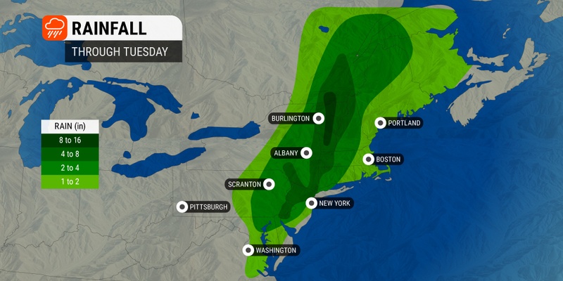
Over 9 inches of rain fell across the state on Monday, washing out roads and creating a precarious situation. Local officials warned that the Wrightsville Damn along the Winooski River was just one foot away from reaching its capacity on Tuesday afternoon.
Should the dam hit this level, water will be released into the North Branch River. Because this dam has never seen this level of water, officials are not certain how the built-in protections will perform.
The Winooski River at Montpelier saw water levels rise almost 14 feet on Monday, easily passing the designated major flood stage. Also in Vermont, the Connecticut River in the southern part of the state is expected to hit moderate or major flood stage prior to finally receding. In the northern part of the state, the Missisquoi River was also nearing major flood stage.
The U.S. Army Corps of Engineers is expecting that the Ball Mountain Dam and the Townshend Dam will both overflow their respective spillways. Residents in Vermont and New Hampshire near these dams are being asked to evacuate.
The city of Montpelier is under an “emergency health order” so that officials can assess the risks to residents in the downtown area. Montpelier Mayor Jack McCullough confirmed that authorities have evacuated the fire department building, the police department facility, and Montpelier city hall.
Government officials are performing their duties at a designated operation center at the water plant. The Montpelier Police Department said that three of its radio towers are also not functioning properly, adding more stress to law enforcement trying to help stranded residents.
According to the National Weather Service (NWS) office in Burlington, Vermont, Montpelier recorded 5.28 inches of rain on Monday alone. The rain event is drawing comparisons to the catastrophic impacts of Hurricane Irene in 2011.
In addition to Montpelier, the neighboring city of Barre also closed its downtown area because of flooding concerns.
U.S. President Joe Biden approved an emergency declaration for the state while also authorizing the Federal Emergency Management Agency (FEMA) to oversee all relief efforts in the region. Meanwhile, neighboring states have sent help to Vermont.
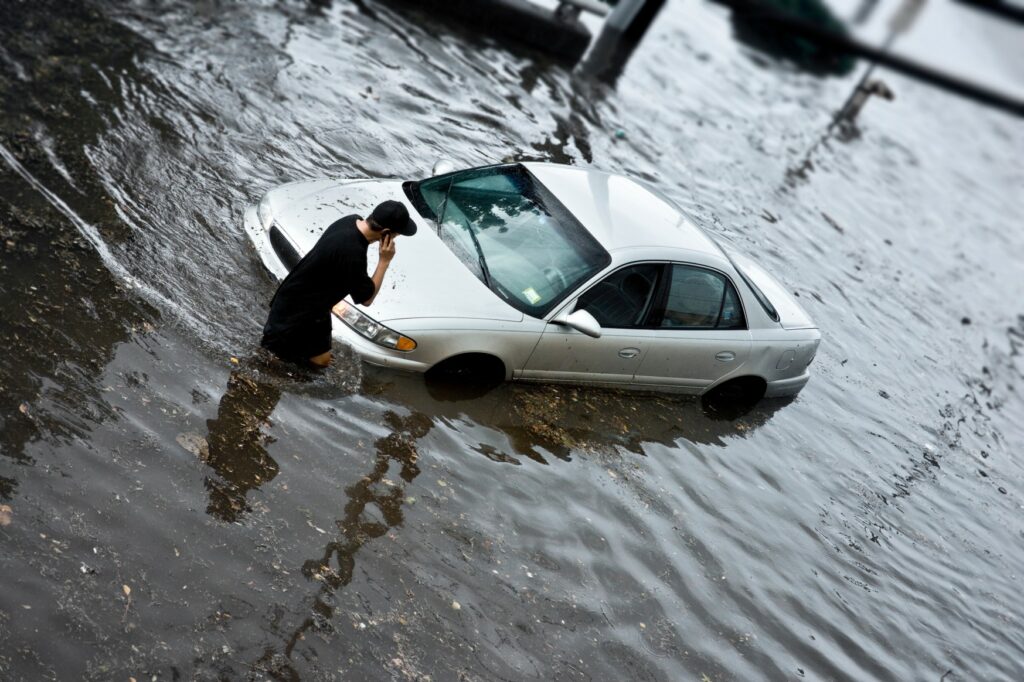
At least two dozen roadways were deemed impassable and closed due to the flooding. Although the water levels are slowly starting to recede in some parts of the state, officials warn that it could get worse before it gets better.
The town of Calais saw the greatest amount of rain out of this weather maker, coming in at 9.61 inches over a period of 48 hours. This town is located about 10 miles north of Montpelier. Plymouth, located about 50 miles south of Montpelier, hit 9.05 inches of rain
New York state also got hit by heavy rain. The Hudson Valley region saw the heaviest amounts of precipitation with over 10 inches of rain recorded in a period of two days. One woman died as flash flooding overtook her home and swept her away. The 43-year-old lost her life in the town of Fort Montgomery.
Numerous bridges in the state collapsed under the weight of the floodwaters. The busy Palisades Interstate Parkway was closed due to the mass amount of damage. In addition, the Orange County town of Highland Falls was cut off from essential services because of road closures.
Experts estimate that the multi-day flooding event will cost the region between $3 and $5 billion. It is difficult to assess the true damage at this point because many of the rural communities have not been able to fully report the impacts. Officials also need the floodwaters to recede to be able to discern the scope of the damage.
Did you find this content useful? Feel free to bookmark or to post to your timeline for reference later.

January 21, 2024

January 19, 2024

January 18, 2024
