
Heavy Rain, Flooding, and Chance of Severe Weather Staring Down the Southern U.S.
January 22, 2024
Posted: January 17, 2023 10:40 am


A storm system that is bringing more rain and snow to saturated California is going to continue pushing to the east in the coming days, delivering a significant chance of wintry precipitation and heavy rain to a large swath of the Rockies, Plains, and the Upper Midwest by the middle of the week. Here is what you need to know as this weather maker makes its way over the Rockies.
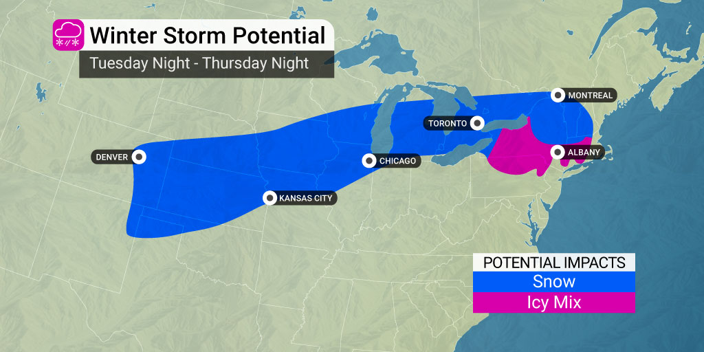
Forecasters are predicting that a strip of land over 1,700 miles long will be in the line of fire for these impacts beginning Tuesday night and lasting through Thursday. A number of major cities will see the effects of this robust system, including Denver, Omaha, Des Moines, Minneapolis, and Milwaukee.
The snow machine will fire up across Colorado’s Front Range on Tuesday night and into Wednesday, creating a winter wonderland for Denver and the surrounding communities. Up to a half of foot of snow may fall in the Mile High City by the time the system ejects into the Plains.

It has been an unseasonably dry start to the year for Denver with only 1.7 inches of snow recorded in January thus far. This storm system will undoubtedly add to this total. The last time that the city saw over 6 inches of snow was December 28. That snow event wreaked havoc across the city and created a number of disruptions during a week when air travel was already compromised because of a variety of complications across the country.
The storm will push through the Rockies and start to gain in intensity on Wednesday as it moves through the central Plains. Snow will begin to fall late Wednesday afternoon in parts of Nebraska and Iowa before reaching the Great Lakes region by Thursday.
The area that will see the heaviest amounts of snow is forecast to be a narrow zone stretching from eastern Colorado into Michigan, including the cities of Omaha, Des Moines, and Green Bay.
Several inches of snow falling over a short time period is predicted to make travel challenging across parts of interstates 29, 35, 39, 70, 80, and 88 starting late Tuesday and potentially lasting through early Friday. You will want to check road conditions if you are headed out on these interstates and surrounding roadways this week.
Forecasters are also warning that the track of the system could wobble in the days to come, putting additional areas at risk and sparing some cities that thought they would be in the line of fire. For instance, a slight shift to the south could translate to snow for the Chicago area. At this point in the forecast, the track of the storm shows it moving to the north of the metro area and hitting Milwaukee with the greatest strength. However, Chicago cannot rule out a change in the forecast.
Weather experts will be watching an earlier storm in the Midwest this week to predict how the bigger system will unfold. The second weather maker is predicted to move farther to the south when compared to its Monday predecessor. This movement to the south will provide the system with more cold air to work with, raising the chances of widespread snow to a greater area.
By Thursday, the stormy system is likely to push into the interior Northeast. This region should be prepared for a mix of snow, sleet, and freezing rain to close out the work week. Meteorologists will be monitoring the progression of the storm system in the coming days to determine exactly how it will unfold when it reaches this part of the U.S.
Did you find this content useful? Feel free to bookmark or to post to your timeline for reference later.

January 21, 2024

January 19, 2024

January 18, 2024
