
Heavy Rain, Flooding, and Chance of Severe Weather Staring Down the Southern U.S.
January 22, 2024
Posted: January 22, 2023 11:27 am


The interior Northeast is in store for an active weather pattern heading through the middle of next week with a mix of rain and snow falling throughout the region over the course of two different storm systems. Here is the latest on this developing weather forecast.
A shift in the jet stream will be responsible for the series of storms gearing up for this part of the country. Before the two major systems push through, a smaller weather maker will bring rain to the mid-Atlantic and snow to portions of New England. This disturbance may also trigger intermittent snow in the eastern Great Lakes and across the central Appalachians.
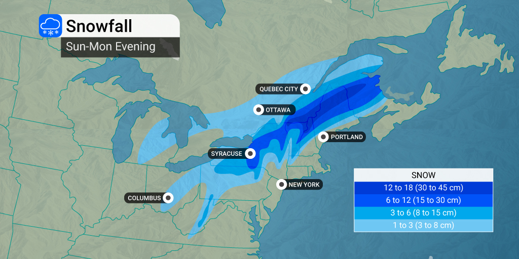
The first storm system is forecast to arrive in the Northeast late Sunday into Monday with the second event firing up on Tuesday or Wednesday, depending on location. The first storm will get its start in the central Plains Saturday evening before moving into the Midwest Sunday morning and eventually the Northeast to close out the weekend.
The snow will likely get going in the higher terrains of West Virginia, Pennsylvania, and New York state by late Sunday afternoon. The flakes will push to the northeast in the overnight hours Sunday. At this point, forecasters are predicting that the snow and rain line will be positioned over the Interstate 95 corridor, leaving those to the east of this boundary only seeing rain.
The areas most likely to see the heaviest snow include upstate New York, northern Pennsylvania, and into New England. Six inches of snow is in the forecast for highest elevations of the Adirondacks and the Green and White mountains in New England.
Warmer temperatures will likely keep this snow on the wet side. This texture will make it more likely to cling to power lines and trees, raising the risk of power outages.
A lack of new cold air coming into the region will also prevent the moisture from changing to snow in areas east of the I-95 corridor. Warm winds coming in from the Atlantic Ocean are working to prevent the mercury dropping too low in areas such as Washington, D.C. and New York City. Even Boston may stay out of the snow line because of this pervasive mass of warmer air.
This storm system is predicted to move through the area quickly, not lasting more than 12 hours in any given location. However, the rain may be heavy enough to create ponding on highways. Low cloud ceilings and fog may also lead to poor visibility on the roads and airline delays.
The rain is forecast to move through the region by Monday afternoon with a mass of colder air filtering in behind the storm system. This dramatic cooldown may cause existing water on roadways to freeze over across the higher elevations of the Appalachians.
The second of the two storms is forecast to fire up late Monday over the southern and central Plains states. This storm will likely move to the Northeast into the Midwest with the bulk of the snow falling to the north and west of the system.
You can also expect a wintry mix in the interior mid-Atlantic and up into New England. The coastal areas will once again be likely spared the snow and ice. There is an outside chance that the major cities of New York City, Philadelphia, and Boston will see a few snow flurries on Wednesday if the system is able to pull in enough cold air.
New York City is currently in the midst of a potentially record-breaking snow drought, sitting at 316 days with no measurable accumulation. The record is 332 days.
The areas most likely to see significant snow accumulation of a few inches or more include areas to the north of Interstate 70 in the midwestern states and in parts of northern New England.
Did you find this content useful? Feel free to bookmark or to post to your timeline for reference later.

January 21, 2024

January 19, 2024

January 18, 2024
