
Heavy Rain, Flooding, and Chance of Severe Weather Staring Down the Southern U.S.
January 22, 2024
Posted: August 27, 2023 9:43 am


Wildfire Activity Forecast to Ramp Up Quickly Out West
Kids are heading back to school all across the country this week, meaning that the start of the fall season is just around the corner. The start of astronomical autumn officially kicks off on Saturday, September 23. The elements of the season will be influenced by a number of factors, including the onset of El Niño, warmer than average sea surface temperatures, and more.
What will the season have in store for the U.S. this year? Here is a peek at the long-range forecast.
Lingering Warmth for the Midwest and the Northeast
Fall will take its sweet time arriving in parts of the Midwest and the Northeast. Temperatures are forecast to linger in the upper 80s and low 90s throughout New York City and Philadelphia well into September, landing just a bit higher than the norm for the beginning of the month. Chicago is expected to continue to see readings of this magnitude through the end of September.
This warmth will begin to fade away into the early parts of October. Unfortunately, the ongoing battle between the cool air filtering down from Canada and the warm air already in place could translate to frequent rounds of thunderstorms for the eastern half of the country.
There is also the chance of an early frost hitting as soon as the end of September for many communities in the Midwest, including Chicago, St. Louis, and Minneapolis. Forecasters are predicting that the Northeast will not experience the first frost until later in October or perhaps even early November. The good news is that this will give farmers more time to harvest crops.
As far as snowfall, the snow machine is not likely to get going in the higher elevations of the region until early October. The lower elevations will hold off until later in October and into November. While a few cities at the lower terrains may see some flurries toward the middle of the season, any widespread significant snowfall is not expected to happen until much later in the fall.
Odds of Tropical Development This Fall
Hurricane experts warn that it could be an active and potentially dangerous fall for tropical weather thanks to the increasingly warm sea surface temperatures in the Atlantic basin. Warmer water provides the ideal breeding ground for tropical events to form and strengthen.
In addition to exceptionally warm temperatures in the Gulf of Mexico, a marine heat wave has been impacting the waters near the coastline of Florida. For instance, sea surface readings near South Florida and across the Florida Keys have been trending as high as 100 degrees.
These readings are well over the threshold needed for tropical development. Last year’s devastating Hurricane Ian was able to grow and intensify so quickly because of the warm waters in the Gulf, eventually making it to a Category 5 storm as it churned toward land.

Meteorologists are predicting that the peak of the 2023 hurricane season will arrive right on time by the end of August and into September. However, if El Niño continues to strengthen in the coming weeks, tropical development may be more limited headed into October and November.
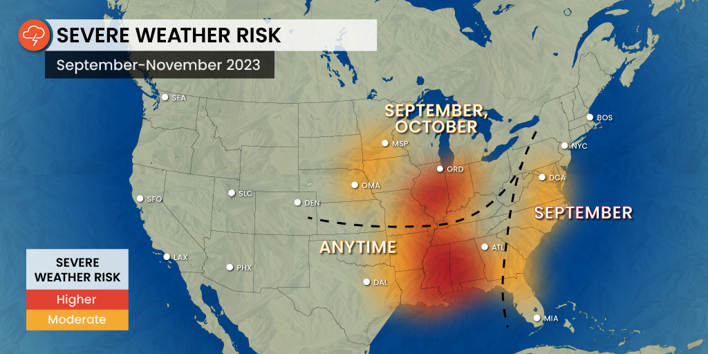
Even in the absence of tropical storms or hurricanes, the Southeast is likely to see a soggy fall. The period of most activity will fall during late September and early October as the temperatures begin to cool and clash with the warm and humid air in place. The areas most likely to see high amounts of storm activity to start the fall season includes the middle and lower Mississippi Valleys and the western portion of the Ohio Valley.
Rocky Mountains and Central U.S. Will See Winter Come in Like a Lion
While it will be a relatively calm start to the fall season for the Rocky Mountain region and across to the central U.S., the end of the fall will likely see an early start to winter like conditions. Forecasters are predicting that temperatures will trend lower than the historical average in October throughout cities such as Denver, Kansas City, Omaha, and Oklahoma City.
In fact, some of these areas could see early season snowfall. However, the long-range forecast is calling for a slight rebound in temperatures in November with readings landing a bit above average for the end of fall. This roller coaster of weather patterns will certainly keep things interesting in this part of the nation.
West to See Increased Wildfire Risk
The hot summer will bring a number of consequences to the West as it relates to wildfire danger. The western part of the country has seen a relatively slow start to the wildfire season due to the wetter than normal winter and spring throughout California and beyond. But this snowpack is beginning to melt off and leave the area more susceptible to fire ignition and spread in the coming weeks and into the fall season.
The warmth and dryness of summer is forecast to linger for awhile in the Southwest and into the Central Valley of California. It will be a different situation in the Pacific Northwest with rain and cooler temperatures predicted to make their appearance with greater frequency starting in September. There is a good possibility that enough moisture in the Pacific will form an atmospheric river across this corner of the Northwest to start the fall season, bringing a load of rain and mountain snow in the process.
Although this rainy pattern is not welcome news for people hoping to enjoy those early fall football games and other outdoor activities, the regular moisture will help to mitigate the risk of wildfires in the Northwest.
The greatest risk of wildfire development in the West will be across Northern California, Idaho, Nevada, and the eastern edges of Oregon and Washington. Forecasters are also predicting that the Santa Ana winds may pick up earlier than usual in Southern California this October, increasing the risk of fire danger in this part of the Golden State.
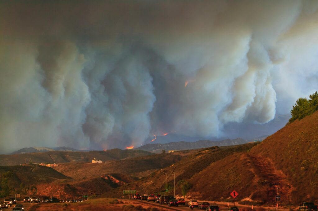
All that said, the total acreage burned from the 2023 wildfire season is still forecast to land below the historical average because of the late start to the development.
Did you find this content useful? Feel free to bookmark or to post to your timeline for reference later.

January 21, 2024

January 19, 2024

January 18, 2024
