
Heavy Rain, Flooding, and Chance of Severe Weather Staring Down the Southern U.S.
January 22, 2024
Posted: August 25, 2023 8:43 am


The 2023 hurricane is nearing its climatological peak in the coming weeks for both the Atlantic and the Eastern Pacific basins. Just as a pair of tropical storms churned up in the Atlantic basin this week, the Eastern Pacific is also getting in on the action with more tropical activity predicted to develop by the weekend. Here is a look at what is going on in the Eastern Pacific.
A surge of activity off the southern coast of Mexico is likely to give birth to two new tropical storms over the next few days. Forecasters are predicting that Tropical Storms Irwin and Jova could form late this week. There is also the possibility that these features could move into Mexico by Saturday and Sunday, bringing heavy rain and high winds.
The new weather makers are coming just a few days after Hurricane Hilary roared through parts of Mexico and the southwestern U.S. last weekend. The good news for storm-weary California is that the two possible storm systems are predicted to impact different portions of the Pacific and are likely to avoid the U.S. altogether.
The first possible tropical feature is forecast to make landfall along the southwestern coastal areas of Mexico. This system is forecast to make its approach to land shortly after taking on the designation of a named feature. The part of Mexico in the crosshairs is accustomed to seeing tropical cyclones fire up and move on land quickly.
Satellite images taken on Thursday indicate a broad area of showers and thunderstorms churning in this part of the Pacific. Meteorologists are predicting that the system has a high chance of becoming more organized as it moves to the north and northwest, potentially taking on the designation of a tropical depression or storm by late Friday or Saturday.
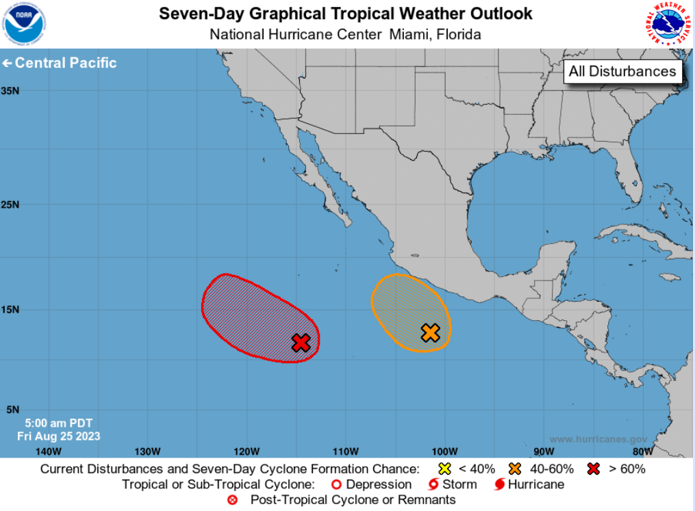
Favorable environmental conditions in the East Pacific will support this rapid development and intensification. However, the storm will likely make landfall before it has time to intensify beyond the status of a tropical storm. Landfall is expected to happen late Saturday or early Sunday.
The portions of Mexico that are under the gun for these tropical impacts stretch from the states of Oaxaca to Jalisco. The higher terrains of this region will be at risk of experiencing mudslides while the coastal areas may see the chance of surge flooding. All areas will be subject to gusty winds and heavy rain.
The precipitation associated with this particular system is not expected to impact the areas that were under Hilary’s wrath last week. This is because the mountains of southern Mexico will act as a barrier to prevent the moisture from flowing northward.
Vacationers along the southern coast of Mexico will want to pay heed to any watches or warnings. For instance, while the travel hotspot of Acapulco is not projected to take a direct hit from this developing system, the area will still possibly see rough surf conditions and strong rip currents.
At this point in the forecast, the models demonstrate that the second feature will not likely impact land. The steering winds located in the part of the Pacific that this storm could pop up is expected to send it to the west. This will translate to minimal impacts to land as it moves to the west.
The official dates for the Eastern Pacific tropical season run from May 15 to November 30. The 2023 season has produced nine tropical depressions, storms, or hurricanes. Eight of these have developed into named storms, including five hurricanes.
Did you find this content useful? Feel free to bookmark or to post to your timeline for reference later.

January 21, 2024

January 19, 2024

January 18, 2024
