Heavy Rain, Flooding, and Chance of Severe Weather Staring Down the Southern U.S.
January 22, 2024
Posted: May 25, 2022 11:41 am


Is the first named storm of the East Pacific tropical season on the horizon? The official start of the season got underway on May 15, however, it is now that things are starting to heat up. Forecasters are currently monitoring potential areas of tropical development in this part of the Pacific Ocean.
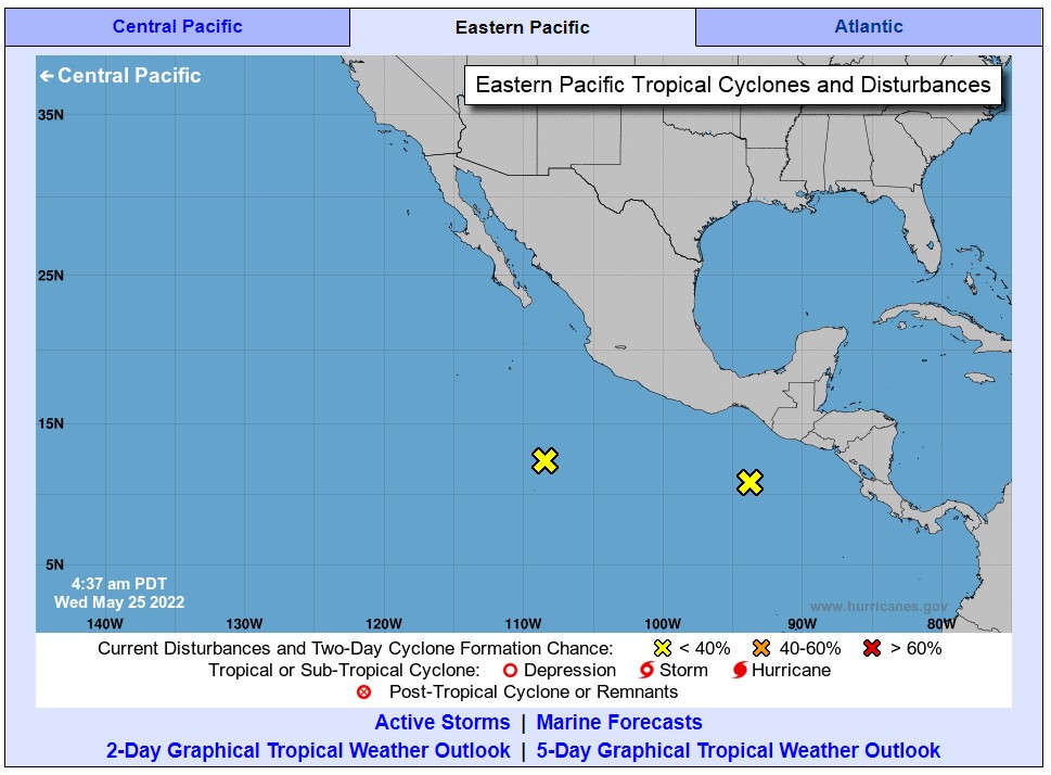
New satellite images reveal a number of large areas of showers and thunderstorms coming together in the ocean waters south of Mexico. While none of these areas are currently exhibiting the counterclockwise circulation associated with a tropical event, hurricane watchers are predicting that this may change in the days to come.
The area most likely to spawn this development is located near the southern coast of Mexico. A large zone of low pressure is forecast to take root by the end of the week, putting in motion a potential tropical development. Forecasters use a number of predictive elements to discern whether any one area of low pressure will intensify into a tropical depression or storm. These factors include the amount of wind shear, sea-surface water temperatures, and the depth of the water surrounding the area of low pressure.

After examining these predictive factors, forecasters are growing more certain that the atmospheric conditions should be favorable for the low to continue to develop, potentially becoming the first named tropical storm of the season. For instance, the current sea-surface temperatures in this region of the Pacific are hovering around 86 degrees. These temperatures typically need to be around 80 degrees in order for a tropical development to take root and become more organized.
An area of intense wind shear is currently located over the bulk of southern and central Mexico. Strong wind shear has been associated with the mitigation of tropical development. However, forecasters are predicting that this wind shear will begin to break up by the end of the week, potentially setting up the necessary atmospheric conditions for the low to progress into a tropical depression or more.
The biggest concern as of late Tuesday is that one particular area of low pressure may intensify and turn toward the north. Should this happen, it would bring impacts to the southern coast of Mexico in areas stretching from Guerrero to Oaxaca. While it is still too early to pinpoint with accuracy a potential landfall, the impacts would likely begin this weekend or early into next week.
The system could bring heavy rainfall and winds to this part of Mexico. The consistent rain typically associated with tropical events also raises the risk of mudslides, especially when the system moves over mountainous areas such as this part of Mexico. Even if this area does not develop into a named storm, forecasters are warning that the southern coast of Mexico is in for a wet and messy ride to close out the month of March.
A storm of this magnitude also brings the possibility of structural damage and widespread power outages. This is particularly worrisome if the storm moves onto shore in areas more vulnerable to this type of damage.
Forecasters are also monitoring a second area of low pressure spinning farther to the west. This area is located far off the coast of Mexico and is not likely to threaten any land masses should it develop. The impacts of this possible tropical event would be limited to those in the shipping industry that routinely travel through these waters.
The first name up on the list of storms for the 2022 East Pacific hurricane season is Agatha. A system will need to intensify into a tropical storm with maximum sustained winds at 39 mph or greater in order to earn a name.
Forecasters are predicting a normal to slightly above normal hurricane season for this corner of the Pacific Ocean. This would translate to about 15 to 19 named storms with about six to eight of them going on to reach the status of a hurricane.
Sharing is caring! Did you find this content useful? Feel free to bookmark or to post to your timeline for reference later!

January 21, 2024

January 19, 2024

January 18, 2024