
Heavy Rain, Flooding, and Chance of Severe Weather Staring Down the Southern U.S.
January 22, 2024
Posted: March 9, 2023 4:43 pm


A monster storm is moving inland from the Pacific Ocean into California, ushering in more precipitation at levels that could trigger dangerous flooding conditions. This is what you need to know about what could be a major weather event for the West Coast.
What is known in meteorological circles as a Pineapple Express is moving into California from the tropical Pacific. Along with immense moisture, this storm system will bring warmer air into the region.
The heavy rain will pose the risk of washing away snowpack at a speed that causes flooding, mudslides, and other types of debris flows. Projected to hit the state by late Thursday or Friday, this latest weather maker is coming on the heels of a series of snow systems that dropped several feet of accumulation over the Sierra Nevada.
Although the warmer temperatures will certainly be welcome, the rising mercury will bring along its own host of problems. Significant snowpack sitting on the higher elevations of the Siskyous and Sierra Nevada will be at risk of melting too quickly as the rain falls down.
The atmospheric river will stretch over 2,400 miles, encompassing an area from Hawaii to California. As the building energy taps into this moisture, it will bring the potential of a foot or more of rain. The good news is that the firehose effect of this type of system means that it will move through at a fast clip, hopefully limiting the amount of rain that falls at one time on any given area.
Temperatures are forecast to hover above freezing at intermediate elevations. This means that the snow already on the ground will melt quickly as it is not able to absorb the rain. As a result, up to 12 inches of water could be released downhill in just a few hours. This runoff could potentially send small rivers and streams beyond their banks.
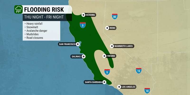
Forecasters are warning that urban flooding will be a possibility in an area from Redding in the northern part of the state down into Santa Barbara. Motorists should be prepared for the possibility of road closures due to standing water and flooding.
In addition, heavy rain will add more weight to the existing snowpack. This is most likely to be an issue in elevations between 5,000 and 7,000 feet. Roof collapses are also a possibility in areas such as Tahoe City.
The snow level is forecast to start at about 7,500 feet. Up to 2 – 4 feet of snow is possible in the high country of the Sierra Nevada. The water temperatures in place will keep the moisture falling as rain across the passes in Southern California. This is good news for a part of the state still dealing with the monster snow storm from a few weeks ago.
More moisture is in store for California and beyond next week thanks to more storm systems that are currently building in the Pacific Ocean. Meteorologists are predicting that another atmospheric river is taking aim at California early next week. Unlike this week’s event that will be concentrated on the northern and central portions of the state, the rain is expected to expand into Southern California.
The heaviest rain will fall late Monday and Tuesday. However, forecasters caution that this timing is still being fine-tuned. Be sure to stay abreast of the changing situation if you live in this impact zone.
Did you find this content useful? Feel free to bookmark or to post to your timeline for reference later.

January 21, 2024

January 19, 2024

January 18, 2024
