Heavy Rain, Flooding, and Chance of Severe Weather Staring Down the Southern U.S.
January 22, 2024
Posted: August 20, 2023 7:12 am


Southern California and parts of the Desert Southwest are already feeling some of the impacts of the arrival of Hurricane Hilary with forecasters warning that the worst is yet to come. Here is what you can expect by the time the storm is over.
Despite further weakening expected as Hurricane Hilary inches closer to California, the storm is predicted to bring a number of life-threatening impacts to the region. These impacts include damaging winds and flooding rainfall lasting through early into the week.
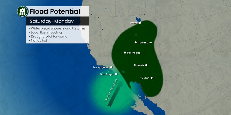
The desert and mountain terrains of Southern California into southern portions of Nevada are going to see the worst of the flooding with up to a year’s worth of rain in the forecast. Hurricane experts are warning that this storm could be an extraordinary and unprecedented weather event for the region.
California Gov. Gavin Newsom declared a state of emergency on Saturday, freeing up resources for the southern portion of the Golden State. The heavy rain falling to the north of Hilary’s track has already prompted flash flooding warnings for some of the desert areas of Southern California to start the weekend.
Hilary came to life quickly in the East Pacific earlier in the week. The feature went through a period of rapid intensification and hit the status of a major Category 4 storm on Thursday, sporting maximum sustained winds of 145 mph as it churned in the ocean waters to the south of Mexico’s Baja California Peninsula. Hilary has since weakened as it moved through the cooler waters to the north. As of Saturday evening, the feature was a Category 2 hurricane with sustained winds of 100 mph.
While forecasters had originally said that it was possible that the storm could make a landfall between Los Angeles and San Diego, the current models show it moving over land near the upper coast of Baja California just on the border of California and Mexico. Hilary is predicted to make landfall in this area as a tropical storm. This designation translates to sustained winds of 39 to 73 mph.
Although the winds will certainly present some degree of danger, the most worrisome aspect of this particular storm is the mass amounts of moisture associated with it. The outer bands of the storm could bring historic rainfall to the region through at least Monday.

The National Weather Service (NWS) out of San Diego issued the first ever Tropical Storm Watch for this part of the state on Friday morning. These watches had been upgraded to warnings for Catalina Island and other areas in the extreme southern part of the coastline by Friday evening.
Ocean water temperatures are hovering well below the 80-degree mark needed for tropical weather systems to survive off of the coast of California. This is why forecasters are certain that the storm will not intensify further as it approaches land on Sunday.
The northwestern corner of Mexico’s Baja California Peninsula will be at risk of experiencing major coastal erosion, flash flooding, and mudslides to end the weekend. The high seas will also present significant concerns for shipping interests in the region.
Southern California will also see these heavy swells Sunday and Monday. In addition, waterspouts and isolated tornadoes could also be in the cards as the system moves through the region on Sunday and into Monday.
The worst of the impacts are forecast to take place late Sunday and into early Monday. Flood watches are now in effect for an expansive portion of California, Idaho, Oregon, Arizona, and Nevada. The anticipated amount of rainfall has already triggered some evacuation warnings in San Bernardino County.
The NWS also issued what is known as a high risk of excessive rainfall alert for some of the low-lying desert areas and into the eastern slopes of the Southern California mountains. This includes the resort town of Palm Springs and across the Coachella Valley in California. Some portions of Southern California and west-central Nevada can expect to see about a foot of rain out of this weather maker.
Las Vegas and Death Valley, California are also in the potential impact zone of destructive flooding. While Phoenix is expected to dodge the heavy rainfall, the western suburbs could see significant amounts of precipitation.
This is a part of the country not used to dealing with rainfall of this magnitude. As such, the region’s infrastructure could struggle to keep up with the moisture. Air travelers and motorists should expect lengthy delays on the road and in the skies for an extended period of time after the storm passes.
For instance, roads may be blocked from fallen trees and power lines due to the high winds. Seaports may also be at risk of closures because of large waves and dangerous seas offshore.
The coastal areas of Southern California should brace for wind gusts up to 60 mph. Gusts approaching 80 mph could be a possibility in the canyons to the east.
The remnants of Hilary will move to the north and the east in the early part of the week, sending the chance of flooding to areas as far as Montana. The thunderstorms associated with this feature will also raise the risk of wildfire danger from lightning strikes.
There have already been some disruptions to everyday life for Southern Californians. The Los Angeles Dodgers, the Anaheim Angels, and the San Diego Padres all decided to play doubleheaders on Saturday while canceling the Sunday games.
The storm is also likely to disrupt the busy growing and harvest season for farmers in California. The San Joaquin Valley is responsible for providing the fertile ground for much of the nation’s fruits and vegetables. The cooler than average spring has already delayed the growing season and this deluge of rain could make matters worse.
Did you find this content useful? Feel free to bookmark or to post to your timeline for reference later.

January 21, 2024

January 19, 2024

January 18, 2024