Heavy Rain, Flooding, and Chance of Severe Weather Staring Down the Southern U.S.
January 22, 2024
Posted: August 21, 2023 10:33 am


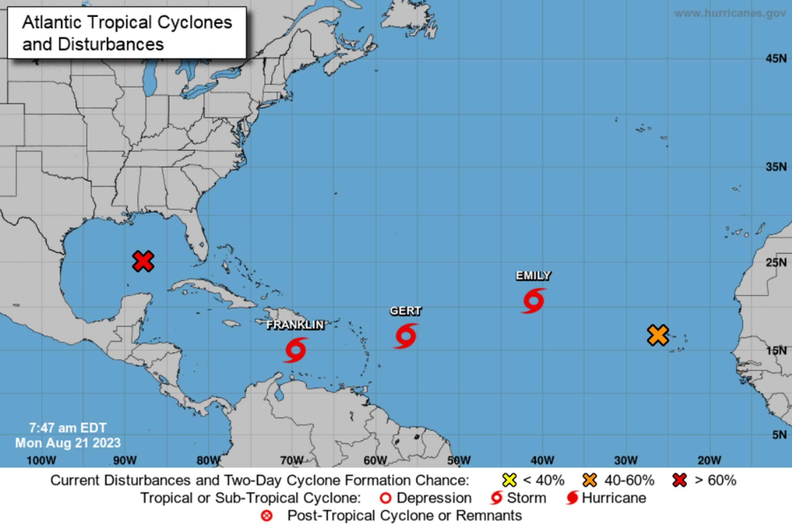
Forecasters are keeping busy this week tracking a number of tropical features spinning around in the Atlantic Ocean. These storms are expected to impact a large part of the basin, expanding from the Cabo Verde Islands, across the Caribbean, and into the Gulf of Mexico. Here is what you need to know if you live in this part of the world.
The National Hurricane Center (NHC) confirmed on Sunday afternoon that Tropical Storm Franklin is now churning in the Caribbean, located at about the halfway point between Venezuela and Puerto Rico. The system is forecast to bring heavy rain to parts of Puerto Rick and Hispaniola later this week. The current models predict that Franklin will make a turn to the north and track into the southwestern corner of the Atlantic Ocean.
While not a named storm yet, a tropical wave moving to the west across Florida on Sunday is bringing a heightened area of rain shower and thunderstorm activity to the Sunshine State. The feature is also triggering rough surf conditions and strong rip currents for the coastal areas of the state.
Forecasters are expecting this wave to continue its jaunt to the west where it will eventually find the bathwater warm temperatures of the Gulf of Mexico. This warmer than average ocean waters will help to support the further development of this feature, giving it a shot to turn into a tropical rainstorm in the coming days.
The wave will need to intensify quickly as it will push into South Texas and begin to break apart at that time. Any amount of rain will be welcome along the Texas Gulf Coast, a part of the state that is currently under the designation of a moderate to extreme drought as defined by the U.S. Drought Monitor. Cities such as Brownsville and Corpus Christi are in desperate need of moisture.
You can expect the surge of tropical moisture to hit this part of Texas beginning late Monday and lasting through early Wednesday. The hardest hit areas of South Texas can count on about 1 – 2 inches of rain out of this weather maker during this time period. Locally heavy rainfall amounts of 2 – 4 inches may also be a possibility.
Although some degree of rain is good news for farmers in the region, the pattern of heavy rain for a few days in a row could create flash flooding conners. The influx of moisture will also work to lower temperatures, providing relief from the searing heat as of late.
The tropical feature will also usher in strong winds Monday night and into Tuesday. Gusts will range from 40 to 60 mph along the coastal areas of the Lone Star State.
The NHC also designated a feature moving east of the Leeward Islands as Tropical Depression 6 on Saturday afternoon. This depression is not likely to stay intact for long as it is expected to begin to lose strength as it moves closer to the Caribbean Islands. The NHC believes that this depression will dissipate starting Monday afternoon as it nears closer to the northern Leeward Islands.
Meanwhile, Tropical Storm Emily is currently churning to the west-northwest of the Cabo Verde Islands. As of Sunday mid-day, the storm was packing peak wind gusts of 50 mph. Emily is expected to to move to the northwest in the coming days before curving to the north starting the middle of the week.
This journey to cooler ocean waters to the north will translate to a weakening. As such, Tropical Storm Emily is projected to transition into a tropical depression by late Monday. While Emily is not going to impact any major land masses, shipping interests in the central Atlantic will want to pay attention to the track of this storm.
Elsewhere in the Atlantic basin, hurricane experts are warning of a high chance of more tropical development in the central portion of the basin and into the Gulf of Mexico. Two additional tropical waves are expected to continue moving to the west from the coast of Africa through late this week. Forecasters will continue to monitor these waves for signs of tropical characteristics as the peak of the 2023 Atlantic hurricane season is right around the corner.
Did you find this content useful? Feel free to bookmark or to post to your timeline for reference later.

January 21, 2024

January 19, 2024

January 18, 2024