
Heavy Rain, Flooding, and Chance of Severe Weather Staring Down the Southern U.S.
January 22, 2024
Posted: July 2, 2023 7:27 am


Will the weather play a role in your Fourth of July plans? While forecasters are still fine tuning their predictions for Tuesday, here is a look at what the weather may look like in your neck of the woods as many Americans enjoy a long weekend.
The American Automobile Association (AAA) is predicting that people will travel in record numbers over the long holiday weekend. The AAA said that domestic travel over the weekend will be up by over 2 million from the same time period of 2022. In fact, the predictions will likely beat the last Fourth of July weekend travel record of 49 million travelers set in 2019.
The latest news headlines have painted a dire picture about the mass flight delays and cancellations. Compounding the issue of airline staffing shortages will be the chance of severe storms potentially snarling both travel on the road and in the air.
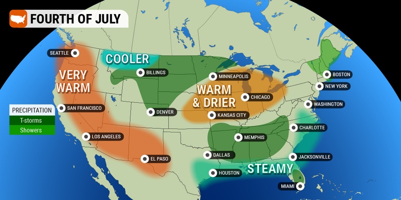
Forecasters are expecting that a shift in the weather pattern for many areas of the country will bring the chance of widespread storms over the weekend and into the holiday. Meanwhile, the southern tier of the country will see the hottest readings of the year.
The slow-moving storm system that produced a derecho in the central Plains this week will churn through the Midwest over the weekend before reaching the Northeast and the mid-Atlantic early in the week. This weather maker will create severe weather on its southern and eastern edges with a steadier rain forming on the northern flank.
The breaking up of the heat dome over the central U.S. will send the thunderstorm activity firing up across the central and southern Plains states, expanding from Texas and up into the Ohio Valley. The storms will eventually reach as far south as the interior Southeast and as far north as the Northeast.
While most of the storms will be benign in nature, you can expect some of the activity to pack locally damaging winds and flash flooding. The storms may also present a problem for the ongoing dry conditions if frequent lightning strikes become a concern.
Saturday’s severe weather impacted a large area from western Missouri to Ohio, expanding as far north as the southern edge of Lake Michigan. The evening activity could have produced wind gusts over 70 mph, large hail, and torrential rain. Cities in the line of fire included Nashville, St. Louis, and Cincinnati.
The storms will move to the east on Sunday, bringing the risk of severe weather to the bulk of Tennessee, Kentucky, West Virginia, Virginia, Maryland, and Delaware. A steady rain will likely thwart outdoor plans for parts of Iowa, Illinois, Ohio, Michigan, and Pennsylvania. You can expect the system to hit upstate New York and New England by Monday.

It has been a relatively cool start to the summer throughout much of the West. For instance, the bulk of California has been enjoying temperatures that have averaged up to 5 degrees below normal for June. Similar conditions have been reported in coastal portions of the Pacific Northwest and across the Desert Southwest.
Las Vegas even set a record for the most consecutive days of no readings in the triple digits. That will change this weekend as high pressure sets up over the region and ushers in the return of consistent readings that land well over 100 degrees.
Central California will be particularly hot with temperatures expected to peak at around 105 degrees by the weekend. For instance, the capital city of Sacramento will peak at 107 degrees on Saturday with readings in the mid to high 90s leading up to the Fourth of July.
Temperatures are expected to take a bit of a tumble across Texas, however, it will remain seasonably warm for the beginning of July. Highs will hover in the 90s for most of the Lone Star State over the weekend and through Independence Day. While this is still hot weather, it will be noticeably more comfortable than the readings in the 100s as of late.
The heat that has been anchored over Texas for the last several days will expand to the east, pairing with surging humidity levels to create uncomfortable conditions for much of the Gulf Coast and the Southeast. Moisture will come up from the Gulf of Mexico to produce sporadic cloud cover and isolated thunderstorms for a large portion of the East Coast.
The increase in the humidity levels will be the most noticeable heading into the early part of next week. Temperatures will trend warmer than normal for a good part of the Southeast with readings landing at slightly below average for most of the Northeast.
The presence of abnormally dry conditions across the Plains could also put some local fireworks shows in doubt. Portions of Missouri, Kansas, Nebraska, Iowa, Oklahoma, South Dakota, and Illinois have been grappling with increasingly dry soil. Local officials warn that this could translate to a ban on some fireworks as well as outdoor flames. Be sure to check with your area’s restrictions before lighting up the night sky or building a campfire over the holiday weekend.
On the flip side, many communities in the West are looking forward to enjoying fireworks spectacles this year for the first time in a few years thanks to the recent relief from the drought on that side of the country.
There is also the chance that fireworks will not be the only thing giving off smoke this year on Independence Day. Smoke from the wildfires in Canada is expected to linger in the Midwest and the Northeast periodically in the days leading up to the holiday.
Changing wind patterns have produced heavy smoke at times for much of the northern half of the U.S. Forecasters warn that wind patterns will continue to shift, leading to variations in the smoky conditions through the first week of July.
Did you find this content useful? Feel free to bookmark or to post to your timeline for reference later.

January 21, 2024

January 19, 2024

January 18, 2024
