
Heavy Rain, Flooding, and Chance of Severe Weather Staring Down the Southern U.S.
January 22, 2024
Posted: August 26, 2023 8:21 am


Southeastern U.S. Could Also See Impacts from This Tropical Activity Next Week
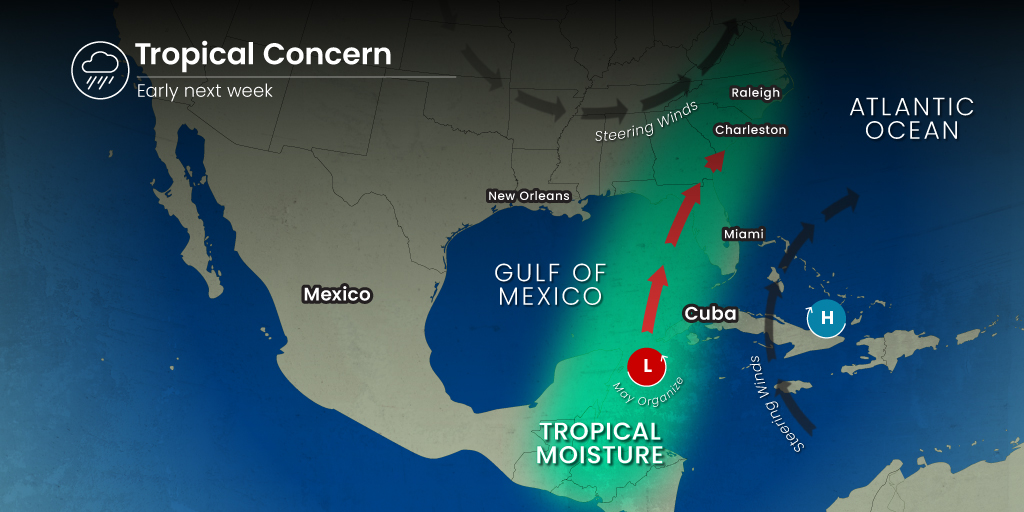
A tropical weather maker could be on Florida’s doorstep by early next week as conditions in the Gulf of Mexico are growing more conducive to rapid development of a new storm system. Meteorologists with the National Hurricane Center (NHC) have been warning for weeks that an area in the warm waters of the Gulf could spur tropical weather development. Here is the latest on this potentially dangerous forecast.
Low Pressure System Could Create Named Tropical System
The west coast of Florida could see a direct strike from a tropical storm or hurricane by the middle of next week as a change in the weather pattern will allow for new development to occur. The system could get its start from a large area of low pressure that is currently anchored over the Yucatan Peninsula of Mexico. This low pressure system is likely to create areas of heavy rain and thunderstorms in an area stretching from the southeastern corner of Mexico over to western Cuba. The exceptionally warm ocean waters in the northwestern Caribbean and the southern half of the Gulf of Mexico will only increase the chances of development by the end of the weekend.
Tropical activity has been suppressed lately in this part of the Atlantic basin due to the presence of wind shear. However, this shear is expected to weaken in the coming days and allow for more fertile conditions in the eastern portion of the Gulf.
As a reminder, a tropical depression is defined as an area of organized circulation with maximum sustained winds measuring between 35 and 38 mph. This system will take on the designation of a tropical storm if its maximum wind speeds range between 39 and 73 mph. A Category 1 hurricane sports sustained wind speeds between 74 and 95 mph.
Without a significant amount of wind shear to break up any budding activity, it will be possible that any tropical depression is able to intensify quickly into either a tropical storm or depression. This is particularly true because of the warmer than normal sea surface temperatures currently circulating in the Gulf.
The next name on the official list of tropical events for the 2023 Atlantic hurricane season is Idalia. Jose is the following name on this predetermined list.
What Parts of the Basin Need to be on Alert?
The southeastern edge of Mexico, western Cuba, and the north-central and eastern portions of the U.S. Gulf Coast should be prepared to see the impacts of any tropical development that could be in the works. Even if this area of low pressure does not birth a named storm, the region will likely see heavy rain and severe thunderstorms starting this weekend and lasting through Monday. Rain squalls could also pose a danger to small watercraft in the Gulf of Mexico.
It is too early to pinpoint with certainty where any potential tropical systems may wander. The Gulf Coast of Florida up through Mobile, Alabama are all at risk of being at the center of the cone of any possible tropical features.
The worst of the conditions are likely to occur late Monday and through Tuesday. Forecasters will be watching to see how quickly this system develops throughout the weekend. Should the system intensify quickly, it would be more likely to make landfall with a compact center of circulation packing damaging winds and elevated storm surge.
On the other hand, a system that is not as strong will have more widespread impacts, however, they will not be as severe. All interests along the Gulf Coast of Florida and up through the Alabama Panhandle should be on alert about the risk of a tropical system landfall on Tuesday or Wednesday.
This potential feature could pack a significant amount of rain, triggering flooding issues by late Monday or early Tuesday. There is also a good chance of tropical-storm-force winds on Tuesday and Wednesday for this region.
Both motorists and air travelers will want to pay attention to the potential of disrupted travel early next week. As with most tropical systems, conditions can deteriorate quickly.

Impacts to the Southeastern U.S.
The forecast steering breezes are predicted to bring any tropical feature in a northeasterly direction late Wednesday and into Thursday. This movement would put the southern Atlantic coast in the bullseye for impacts.
There is also the chance that this weather maker could emerge intact over the Gulf Stream Atlantic waters by Thursday. The warm waters in this stream would provide the fuel for re-intensification. Conversely, the system would lose steam if it remained over land.
A separate weather front is also forecast to stall out over the southeastern U.S. on Monday through Wednesday. This front is expected to usher in flooding downpours and gusty thunderstorms in an area separate from the severe weather that is likely along the Gulf Coast. This will be another area to keep a close eye on heading into the new week.
Did you find this content useful? Feel free to bookmark or to post to your timeline for reference later.

January 21, 2024

January 19, 2024

January 18, 2024
