
Heavy Rain, Flooding, and Chance of Severe Weather Staring Down the Southern U.S.
January 22, 2024
Posted: July 7, 2023 9:27 am


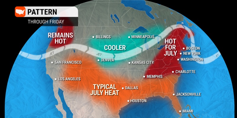
The mercury is on the uptick in the eastern portion of the U.S, putting some areas at risk of seeing their first official heat wave of the year. How long will this heat stick around and where will the temperatures increase to the greatest degree? Read on for all of the details of this hot and humid forecast.
The East Coast is forecast to remain in this hot and humid weather pattern for the rest of the week. In fact, some communities will experience their first heat wave of the season as the mercury continues its upward trajectory. While the Northeast sees climbing temperatures, the Southeast will be stuck in a humid weather cycle.
This weather pattern is typical for the beginning of July. While the weather is great news for beach goers or those looking to head out for a camping adventure, the heat will put additional strain on some of the already stretched energy grids throughout the region.
Places such as Philadelphia are predicted to record consecutive days of readings at or above 90 degrees with these readings in the forecast through Friday. While these readings will not come close to equaling last summer’s two heat waves in the City of Brotherly Love, many people find it difficult to acclimate to the first real hot days of the summer.
In meteorological terms, a heat wave in this part of the country is defined as at least three consecutive days of temperatures in the 90s. The northern and western suburbs of New York City may also notch its first heat wave of the year. The southern and eastern portions of the metro area typically see more cooling sea breezes.
You can expect highs in Central Park to land in the upper 80s and low 90s through the end of the work week. The mercury hovered in the low 90s in Manhattan on Wednesday.
Heading down the Interstate 95 corridor to Washington, D.C., the daily high temperature is also expected to soar into the low 90s through Friday. The historical average high for the nation’s capital during this time of the year hovers in the upper 80s and near 90 degrees, putting these forecast readings just slightly above this norm.
Combined with the hot July sun, real feel readings in the Northeast will soar well into the 90s and potentially even crack the century mark. A lack of wind and high humidity levels will drive these readings even higher in the coming days.
The heat will feel more remarkable coming on the heels of an unseasonably cool June for the bulk of the East Coast. Most major cities in the region saw temperatures that ranged between 1 and 4 degrees below the historical average for the sixth month of the year.
An abundance of moisture in the air will keep the high humidity levels in place across most of the Southeast for the short-term forecast. While temperatures will drop slightly compared to last weekend’s readings in the mid to upper 90s, the rising humidity will still make it feel like a sauna in this corner of the U.S.
It will remain unseasonably hot in Florida through the weekend with temperatures expected to trend several degrees above normal. This will translate to widespread readings in the mid to upper 90s for the Sunshine State. The beach will be one of the few places to find relief on the peninsula.
The good news is that the wildfire smoke that has been impacting the Northeast in recent weeks will remain at bay over the next few days. Instead, the current wind patterns will send the smoke from the Canadian wildfires into the Pacific Northwest and across to the northern Plains.
Any smoke that moves to the East Coast of the U.S. this weekend will likely remain at higher levels in the atmosphere. This means that the result will likely be hazy sunshine and not poor air quality levels.
However, forecasters are warning that a significant storm system could be on tap for northern Ontario by next week. Should this storm take root as the models are suggesting, the counterclockwise circulation surrounding this weather maker could send noticeable amounts of snow back into the Midwest and the Northeast.
The heat and high humidity levels will increase the odds of thunderstorm activity in the Southeast over the next few days. These potential storms would carry the typical risks of strong winds, frequent lightning strikes, and heavy rainfall.
A southward dip in the stream across the Midwest on Thursday may encourage the development of thunderstorms in the central and northern Appalachians later in the day Friday. These storm cells could make their way up the Interstate 95 corridor in time for the Friday evening commute. The storms are expected to remain clear of the coastline, keeping those beach plans safe.
Heading into the weekend and early next week, the jet stream is expected to keep its movement to the south. This movement will bring up more moisture from the Gulf of Mexico, helping to cool the temperatures but bring humidity levels higher.
This combination may lead to a higher chance of thunderstorms and heavy rain in the eastern U.S. to close out the weekend and start the new work week.
You will want to stay tuned to this forecast in the coming days as the weather pattern may trend in an unsettled direction.
Did you find this content useful? Feel free to bookmark or to post to your timeline for reference later.

January 21, 2024

January 19, 2024

January 18, 2024
