Heavy Rain, Flooding, and Chance of Severe Weather Staring Down the Southern U.S.
January 22, 2024
Posted: August 16, 2023 9:45 am


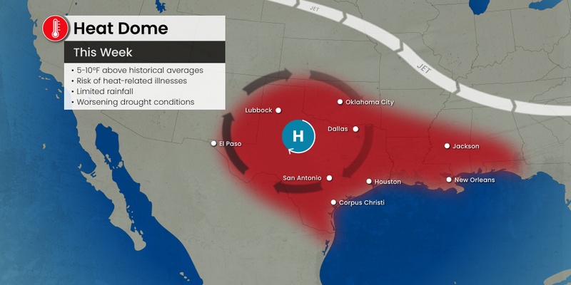
Just when many people thought they were out of the woods with the heat, Mother Nature is flexing her muscles and sending the temperatures soaring once again. A large heat dome is set to build over the central portions of the country this week, bringing the warmest readings of the year for many cities in its path.
Meanwhile, a surge of tropical moisture could work to trim the temperatures for the bulk of the southern U.S. Here is a look at this forecast.
Some significant changes are on the way for much of the U.S. by the end of the week. The mercury is forecast to climb into the upper 90s and triple digits for cities such as Chicago, St. Louis, and Minneapolis as the heat dome that had been anchored over the Southwest and the southern Plains moves to the north.
The temperatures will begin to fall across the South as this area of high pressure pushes northward. Nobody will welcome this break from the heat more than Texas, a part of the country that has been seeing temperatures hover 3 to 5 degrees above normal since the beginning of June.
For instance, Houston has seen the triple digits on all but one day in August. The historical average for this month in the city is in the mid 90s. In addition to the blistering afternoon temperatures, overnight lows have remained planted in the 80s for most of the month, translating to little relief after the sun goes down.
Texas is not the only state in the southern U.S. that has seen this relentless heat. The higher than average temperatures have expanded across the Gulf and well into Florida to the east and to the west into Southern California.
The heat dome that is migrating northward is forecast to linger for up to a week in some areas. This means that many areas in the Midwest and up into the northern Plains may see the sizzling heat into early next week. Several cities can expect readings to crack the century mark.
Triple digit readings are in the forecast for Kansas City, Omaha, St. Louis, Des Moines, and more. Meanwhile, the mercury will hover in the 90s for Chicago and Minneapolis.
The ongoing drought that has been a mainstay of the weather pattern in a large part of the central U.S. is partially to blame for the building heat. According to the latest data from the U.S. Drought Monitor, parts of Kansas, Missouri, Nebraska, Iowa, Minnesota, and Wisconsin are all dealing with various stages of severe to exceptional drought.
The sun is able to go to work to heat up the dry ground at a faster clip when compared to moist ground. This translates to temperatures that are able to climb more quickly.

While the Midwest experiences some of the hottest readings of the summer, the southern tier of the U.S. will finally see a respite from the heat. This includes the Gulf Coast, parts of the southern Plains, and into the Southwest.
As the high pressure system takes up residence over the Midwest, the clockwise circulation around this dome will support the movement of tropical moisture from the Gulf of Mexico into the southern U.S.
This mass of moisture will bring down the temperatures for the Gulf Coast and into Texas by the start of next week. Forecasters are warning that the moisture and energy in place may be sufficient enough to create a tropical depression over the western or northern portion of the Gulf.
A train of moisture from the Pacific Ocean will also work to dial back the temperatures in the western U.S. This moisture-rich air will ease the temperatures and dry conditions up and down the Pacific Coast and inland into Arizona, New Mexico, Utah, and Idaho.
This cooling will be welcomed with open arms across the Pacific Northwest, an area of the nation currently dealing with some of the hottest temperatures of the week. The arrival of more clouds will also help to suppress the mercury in this corner of the U.S.
You can expect temperatures to fall by 20 to 30 degrees across parts of Washington and Oregon. For instance, Seattle will see the mercury fall from the low 90s to start the week into the 70s by Friday.
Hurricane experts are also monitoring the start of a new tropical feature in the eastern Pacific. This system could work to move moisture into northwestern Mexico, the Desert Southwest, and parts of Southern California over the weekend. It has been a relatively slow start to the North American monsoon system, however, that could change by next week.
Although the rain on its own is good news for the dry region, the arrival of thunderstorms will elevate the risk of wildfires due to the frequent lightning strikes. In addition, locally heavy rain will raise the threat of flash flooding events across the Southwest.
On the other side of the heat dome, a series of thunderstorms are expected to push down from central Canada into New England, the Appalachians, and the mid-Atlantic beginning this weekend and lingering into next week. These storm cells could pack the potential of high winds, heavy rain, and derechos as the hot air circulating to the south goes to battle against the cool air from Canada.
Meteorologists are cautioning that these storms could end up being some of the most severe of the summer. The onset of these storms will serve as the best chance to break apart the heat dome over the Midwest and bring relief to the nation’s heartland.
Did you find this content useful? Feel free to bookmark or to post to your timeline for reference later.

January 21, 2024

January 19, 2024

January 18, 2024