Heavy Rain, Flooding, and Chance of Severe Weather Staring Down the Southern U.S.
January 22, 2024
Posted: April 5, 2022 9:00 am


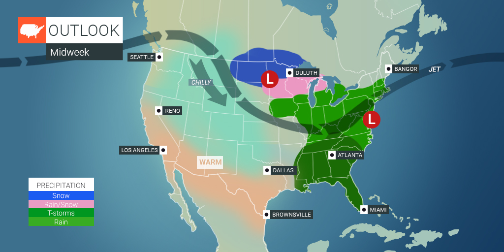
The Northeast and the mid-Atlantic are in line to get more rain in the coming days, continuing the trend of a soggy start to April. Two different storm systems are going to bring more moisture to the region, increasing the risk of heavy downpours and severe thunderstorms.
A southward dip in the jet stream is expected to create severe weather across the southeastern corner of the U.S. on Tuesday and Wednesday. This same dip will also be what produces the rain that is gearing up to fall in the mid-Atlantic.
The first round of active weather is forecast to dump between 0.75 to 1.25 inches of rain up and down the busy Interstate 95 corridor between Washington, D.C. up through Boston. This will put some of the most populated areas of the East Coast under the gun for heavy rain. The precipitation is expected to begin late Tuesday afternoon just in time for the commute home. The rain will fall off and on in the overnight hours into Wednesday morning.
The highest chance of the severe weather will happen in areas of the mid-Atlantic, including Charlotte and Wilmington. However, thunderstorms that trigger flooding may surge as far north as Washington, D.C. and into the Delmarva Peninsula. The heavy rain and gusty winds may create poor visibility and pooling water along some parts of Interstates 40, 64, 70, 81, 85, and 95. Motorists should remain alert as the storms and heavy rain move into the region.

While the rain may create some travel issues, there is no doubt that some of the Eastern Seaboard could use the precipitation. According to the U.S. Drought Monitor, much of the Southeast and mid-Atlantic are under a drought designation. For example, some parts of eastern North Carolina at only about 60% of the average precipitation for the month of March.
The parts of the mid-Atlantic currently dealing with minor drought conditions include Maryland and Delaware. Meanwhile, farther to the north, New Jersey and Pennsylvania are experiencing abnormally dry conditions. The forecasted rain for this week will certainly be a welcome relief to these areas.
The second round of wet conditions could possibly bring even more rain and wind than the first system that pushes through. This second punch is expected to move at a slower pace, adding to the total rainfall amounts. A front will move from the Great Lakes into the East Coast late on Wednesday, igniting a new round of severe weather near the coastal areas of the mid-Atlantic and into the Northeast.
This storm will bring another 1 to 2 inches of rain on Thursday with the greatest impacts coming in an area stretching from the Jersey Shore up into New England.
Thursday will also bring the potential of severe weather in the Carolinas through Delaware and the southern portion of New Jersey. This line of storms is forecast to bring strong winds, heavy rains, small hail, and the chance of flash flooding. Coastal cities such as Myrtle Beach and Atlantic City will bear the brunt of the activity with the storms potentially stretching as far inland as the Research Triangle in North Carolina and Washington, D.C.
By the end of the week, a surge of warm air will move into the eastern portions of the U.S. For instance, highs in New York City on Friday will hover in the low 60s, a departure of about five degrees from normal. The warmup will hit the southeastern U.S. earlier in the week, with daily readings expected to be well above normal by Wednesday.
The weekend will bring a return to cooler temperatures. However, the moisture is expected to be limited for most areas of the East Coast.
Spread the word.
Did you find this content useful? Feel free to bookmark or to post to your timeline for reference later!

January 21, 2024

January 19, 2024

January 18, 2024