
Heavy Rain, Flooding, and Chance of Severe Weather Staring Down the Southern U.S.
January 22, 2024
Posted: September 27, 2023 10:14 am


A new tropical storm system could be headed for the U.S. coastline. However, unlike Tropical Storm Ophelia that impacted the East Coast, this latest homegrown system would come onshore along the Gulf Coast. Here is what forecasters are saying about this potential tropical weather development.
Warm Waters in Gulf of Mexico Could Fuel Tropical Weather Development
Just like last week when a homegrown system popped up in the Atlantic Ocean off the coast of the Carolinas, conditions are ripe for a storm with tropical characteristics to form on its own. Even if the feature does not officially transition into a named storm, it will likely bring a surge of tropical moisture to the Southeast and Gulf Coast in the coming days. In addition, the weather could also bring a number of coastal hazards to the Eastern Seaboard.
This area of ocean stretching from the northwestern corner of the Caribbean and into the south-central and southeastern portions of the Gulf of Mexico typically produces tropical weather during this time of the year. The zone most likely to produce a tropical feature in the near future will be just south of a stalled front in the southeastern U.S.
Recent satellite images from Monday morning have shown a large area of rotating clouds, rain showers, and thunderstorms spinning in the northwestern Caribbean Sea. This moisture could merge with the stalled front to produce a tropical feature. This is a part of the Atlantic basin that has not seen the cooling effects or recent tropical activity, making it more likely to provide the fuel needed for storm development.
Additionally, the temperatures in the waters in the Gulf of Mexico are still well over the threshold needed for tropical development. These readings need to be near 80 degrees for a tropical system to form. The latest readings indicate that the sea surface temperatures across the Gulf of Mexico are trending in the 80s.
While the waters are certainly warm enough to support tropical development, a good amount of wind shear is combining with some areas of dry air to prevent what the National Hurricane Center (NHC) refers to as “rapid intensification.” This means that any feature that does try to take root may not take on all of the typically defined tropical characteristics. These conditions also make it more likely that organization that does happen takes place more slowly.
What Parts of U.S. Could See Impacts
The current forecast for steering breezes in this part of the basin predict that any potential disturbance will move to the west or northwest this week before tracking farther to the northeast. This path would take the system toward Florida.
You will want to keep an eye on this potential development if you live along the Gulf Coast, in Florida, or in the Southeast. While a tropical weather event would certainly wreak havoc on outdoor plans, the moisture will be advantageous for the Gulf Coast of Florida, a part of the Sunshine State that has been dealing with growing drought concerns.
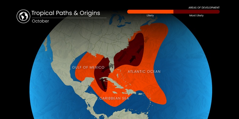
Heading into October, the part of the Atlantic basin stretching from the western Caribbean and into the central and eastern waters of the Gulf of Mexico are mostly likely to see tropical storm formation. This is because the tropical waves that generally come off the coast of Africa early in the season tend to die down during the fall months. As a result, the primary development zone during the tail end of the Atlantic hurricane season is typically located in the Gulf of Mexico.
Rough Seas for the Eastern Seaboard in the Forecast
Even in the absence of a homegrown tropical system spinning up in the Gulf, the Eastern Seaboard is forecast to experience rough sea conditions for the majority of this week. Stiff winds out of the northeast associated with an area of high pressure coming down from Canada and into the Northeast will whip up these winds and churn up the seas in the process.
Beachgoers and boaters from northeastern Florida and up through Long Island, New York will want to be aware of the possibility of rough surf conditions, beach erosion, dangerous rip currents, and coastal flooding through the end of this week.
Did you find this content useful? Feel free to bookmark or to post to your timeline for reference later.

January 21, 2024

January 19, 2024

January 18, 2024
