
Heavy Rain, Flooding, and Chance of Severe Weather Staring Down the Southern U.S.
January 22, 2024
Posted: January 25, 2023 7:13 pm


The National Weather Service (NWS) has weighed in on a tornado that ripped through the Houston suburb of Deer Park on Tuesday, giving it an EF-2 rating. Here is the latest on the severe weather from Tuesday and what is on tap for the hours ahead.
Houston was ground zero for the severe weather that roared across the Gulf Coast on Tuesday. The twister hit the suburbs of Deer Park and Pasadena at shortly before 2:30 pm. In addition to sending debris all over the region, the storms also dumped so much rain that water rescues needed to be performed to save lives. Fortunately, there were no deaths or major injuries reported.
There were 17 reports of tornadoes in Texas and Louisiana by the time that the day was over with the majority of the events happening near the border of Texas and Louisiana. Up to 30 structures sustained significant damage in Deer Park with at least 30 roads closed as a result of fallen trees and downed power lines. Damaged buildings included a nursing home, a church, and a wastewater facility.
Nearby Pasadena also reported substantial damage to schools, homes, and businesses. The Pasadena Animal Shelter is in need of foster families after the twister tore off the roof of its facility. Other animal shelters in the area are helping to care for the displaced pets. The suburb also saw damage to cars at the local high school and the destruction of a gym.
There were still 40,000 customers in the dark in the region because of the severe weather by the time that the sun came up on Wednesday. The storms also ushered in heavy rain and that set off flooding in the vulnerable Houston area. Over 4 inches of rain was recorded at George Bush Intercontinental Airport, shattering the previous daily record of 1.94 inches from 2011.
Some of the areas surrounding Houston saw over 5 inches of rain out of this intense storm system. San Felipe reported 5.49 inches of rain by the time the storms let up.
The rain also stranded motorists throughout Harris County. The Harris County Sheriff’s Office confirmed that it had to rescue a school bus after it became stranded in a ditch. Portions of interstates 45 and 10 were hit particularly hard with the floodwaters, prompting numerous water rescues.
While not as impressive as the rain in the Houston area, the capital city of Austin also saw record-breaking rainfall. Austin-Bergstrom International Airport recorded 1.23 inches of rain, breaking the past daily record of 0.81 of an inch set back in 1974.
Texas and Louisiana are not the only areas dealing with widespread power outages. As of Wednesday morning, over 150,000 customers in Missouri and Arkansas do not have power due to snow that pounded the region with 6 to 12 inches of accumulation. The majority of the power outages are across the northern portion of Arkansas and southern Missouri. Arkansas’ Stone County and Missouri’s Oregon and Howell counties were hit especially hard by the power outages with the overwhelming majority of the customers in the dark.
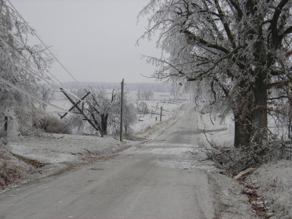
The Ozark Mountains across Missouri and Arkansas bore the brunt of the snow with some areas seeing over a foot of the white stuff. For instance, Chimes, Arkansas hit the 12-inch mark while Everton, Arkansas came in at 9.5 inches. The Texas Panhandle also recorded significant snow, including the town of Matador reporting 10 inches.
This snow line is forecast to move farther to the northeast on Wednesday, setting its sights on the Ohio Valley and the Northeast. Hundreds of flights have already been delayed or cancelled as the snow machine fires up, including widespread disruptions at Chicago O’Hare International and Chicago Midway International Airport. It is a good idea to check with your flight status if you are planning to take to the friendly skies in the near future.
Wednesday has already been a busy day for storm chasers across the Southeast and into the Florida Panhandle. The Tallahassee metro area was put under a tornado warning late in the morning after a twister was spotted in the area.
The storm cells will continue to push to the northeast as the day continues, bringing the risk of severe weather up through southern Virginia. Winds may hit hurricane force speeds of 75 mph in some regions, including along the Interstate 95 corridor.
It has been an unusually active month for tornadoes. Prior to Tuesday’s outbreak, there had been 102 confirmed tornadoes this January. This is good enough for third on the list of this month of the year with a few days left. While Tuesday’s additions may bring the number closer to second place at 137, it is unlikely that 2023 will break the all-time record of 214 from 1999.
The higher than usual number of tornadoes is being attributed to warmer than average air temperatures as well as sea surface readings that are trending well above normal in the Gulf of Mexico.
Did you find this content useful? Feel free to bookmark or to post to your timeline for reference later.

January 21, 2024

January 19, 2024

January 18, 2024
