
Heavy Rain, Flooding, and Chance of Severe Weather Staring Down the Southern U.S.
January 22, 2024
Posted: October 11, 2022 12:46 pm


It has been over two weeks since Hurricane Ian slammed into the coast of Southwest Florida, taking the lives of over 100 people as a strong Category 4 storm. While the cleanup and rebuilding efforts will undoubtedly be a long process, this is a good time to reflect on the storm and take a look inside the numbers.
Ian is officially now distinguished as the deadliest tropical event to hit the Sunshine State in 87 years. Ian got its start on September 23 as a tropical depression in the south-central Caribbean Sea. The storm evolved into a hurricane on September 26 as it picked up strength near the Cayman Islands.
This group of islands began to feel the impacts that same day as winds reached over 50 mph in many areas. Almost 69,000 residents in Grand Cayman were under a hurricane warning as the storm inched closer.
The storm continued to move to the north and evolved into a Category 2 hurricane the next day. It did not take long for Ian to intensify even further, reaching a Category 3 designation on September 27 as it churned in the exceptionally warm waters of the Caribbean Sea.
Ian made its first landfall on Cuba in the Pinar del Rio province with sustained wind speeds reaching 125 mph, just 4 mph from hitting a Category 4 designation. The western side of Cuba bore the brunt of the storm and its high storm surge and gusty winds.
The entire island nation experienced a blackout, including the capital of Havana. Although it is located approximately 100 miles from where Ian made landfall, Havana recorded a wind gust of 87 mph. Two deaths were blamed on the storm in Cuba.
Ian was able to hang on to its Category 3 status as it moved back into the Atlantic basin. The storm underwent a period of rapid intensification in a period of only two and a half hours, putting it just shy of a Category 5 storm.
It only took 24 hours for Ian to reach Florida after exiting off the coast of Cuba. Ian slammed into the barrier islands of Southwest Florida at about 3 pm local time on September 28, packing maximum sustained winds of 150 mph. This statistic puts Ian as the fourth-strongest hurricane to ever make landfall in Florida.
Ian was also the first Category 4 hurricane to hit the southwestern corner of Florida since Charley in 2004. The highest wind gust associated with Ian was recorded in Grove City, measuring 128 mph. A NOAA station positioned on Captiva Island saw a gust of 120 mph.
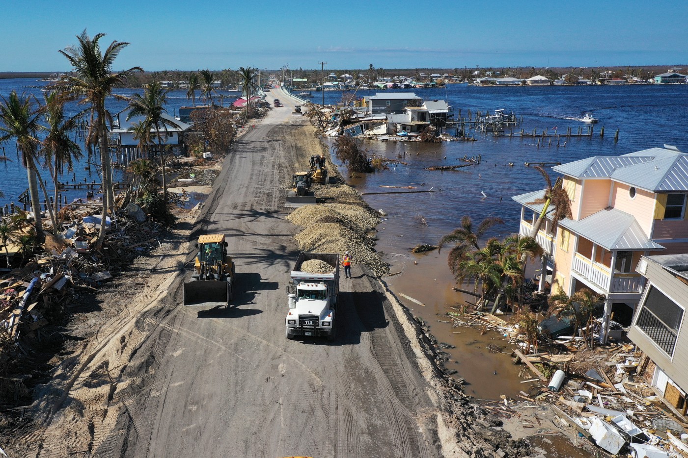
The storm surge with Ian was also one for the record books. The surge hit up to 18 feet along some of the barrier islands near Fort Myers. A storm surge gauge in downtown Fort Myers indicated a measurement of 7.24 feet.
Farther to the south, a gauge at the Naples Pier recorded a surge of 6.28 feet. However, the gauge then went offline after the pier was severely damaged. Other areas that experienced catastrophic storm surge included Sanibel Island, Fort Myers Beach, and Pine Island.
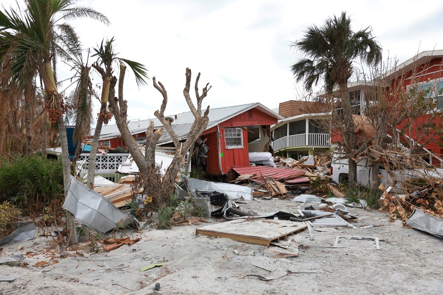
Residents of Sanibel Island returned home after evacuation to find their homes completely destroyed. The only bridge connecting Sanibel to the mainland was partially swept away, cutting off all access to the island. The devastation was equally extreme on Pine Island, off the coast of Cape Coral.
While the winds died down rather quickly as Ian moved onshore, the rain continued to come down in droves. Over a dozen rivers reached major flood stage throughout the state.
The central portion of the Florida peninsula was hit particularly hard with the heavy rain in the overnight hours. A gauge in Titusville recorded 26.42 inches of rain before the storm moved through. This number represents over three times the amount that typically falls throughout all of September.
It is also much more rainfall than what the area nearest the landfall measured. For instance, most areas around Fort Myers recorded 15 – 20 inches.
Ian’s journey was not done after it moved off into the Atlantic Ocean. Although it quickly weakened into a tropical storm, it was able to intensify back into a hurricane as it moved toward the coast of the southeastern U.S.
Ian was a Category 1 hurricane with winds of about 85 mph when it made landfall to the southeast of Georgetown, South Carolina. The strongest wind gust in the region was recorded on Shutes Folly Island in Charleston Harbor at 92 mph.
While the storm surge paled in comparison in the Southeast when compared to Florida, it was still enough water to cause significant damage. Piers and boardwalks up and down the coasts of Georgia and the Carolinas were damaged as the water rose. A gauge at Wrightsville Beach in North Carolina recorded a surge of over 4 feet, making it the second-highest water level this station has ever seen. Fort Pulaski, Georgia recorded a surge of 3.85 feet, the third-highest ever seen at this location.
Rain was another issue as Ian moved into the region. Charleston, South Carolina measured over 8 inches of rain, triggering flooding throughout the historic coastal city.
At least five deaths were attributed to Ian in North Carolina.
The remnants of the storm went on to deliver torrential rain up into the mid-Atlantic and into southern New England.
It is still too early to understand the full scope of Ian’s economic impact. The total losses will likely fall between $180 billion and $210 billion in the U.S. alone. This would put it on the same scale as 2012’s Hurricane Sandy.
Widespread power outages led to more losses. At the height of the storm, there were over 3.2 million customers in the dark.
State officials in Florida are also warning that citrus crop losses may total up to 80%. This will certainly cause a spike in the price of these products in the near future.
Did you find this content useful? Feel free to bookmark or to post to your timeline for reference later.

January 21, 2024

January 19, 2024

January 18, 2024
