
Heavy Rain, Flooding, and Chance of Severe Weather Staring Down the Southern U.S.
January 22, 2024
Posted: June 1, 2022 4:03 am


As the first named storm of the East Pacific hurricane season churns through southern Mexico, forecasters are predicting that the Atlantic basin may also see its first development.
The coast of southern Mexico is currently dealing with a record-setting hurricane landfall, bringing a host of dangerous weather conditions to this vulnerable region. Here is a recap of the historic Hurricane Agatha as well as what the Atlantic basin can expect for potential tropical weather development in the near future.
Hurricane Agatha made history on Monday afternoon when it became the strongest storm to ever make landfall in Mexico this early in the Pacific hurricane season. Hurricane Agatha came onto shore just to the west of the town of Puerto Angel packing maximum sustained winds of about 105 mph, making it a Category 2 storm. Despite the intensity of Agatha when it roared onto shore, it could have been a lot worse. The storm had almost been at a major hurricane status earlier in the day before it weakend slightly prior to landfall.
It was only the third time that a hurricane made landfall in this region of the eastern Pacific during the month of May. The two previous storms to carry this distinction were Hurricane Barbara making landfall in Mexico on May 29, 2013 and another Hurricane Agatha coming on shore on May 24, 1971. Both of these May storms were just Category 1 storms when they made landfall, giving 2022’s Hurricane Agatha the crown of being the strongest storm during the month of May.
Hurricane Agatha was also the earliest hurricane to form in this part of the ocean since Andres on May 29, 2015.
There is at least one reported death and several additional missing individuals in the state of Oaxaca due to a mudslide triggered by the heavy downpours from the storm system. As of Tuesday, what was once a hurricane is now a tropical rainstorm as the storm weakened considerably once it met up with mountainous terrain of southern Mexico. Oaxaca was left to deal with heavy rains and intense winds during the worst of the storm.
Trees were uprooted and thrown to the ground in the popular resort region of Huatulco after Agatha roared through. Officials in Huatulco were forced to close all of the region’s beaches in advance of the storm. Schools were also closed as a result of the storm’s impacts.
As is often the case with tropical weather events over the rugged terrain of Mexico, mudslides were a chief concern. The heavy rains led to these mudslides, sending rocks and mud spilling out into the area’s major roadways, including two highways running through Oaxaca.
The strong wind gusts also brought down power and communication lines, making it difficult for authorities to communicate both with each other and to worried citizens. While the worst of Agatha has passed, forecasters are calling for more consistent rain in the coming days, bringing a continued risk to the water-logged area.
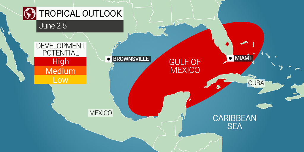
Although forecasters do not predict any additional threats in the coming days in the East Pacific, it may be a different story for the Atlantic basin. There is a chance that the leftover energy and moisture from Agatha could work together to create the Atlantic basin’s first named storm of the 2022 season as this system potentially gains new life in the southern Gulf of Mexico or the northwestern corner of the Caribbean Sea by the end of the week.
Meteorologists are now predicting that there is a high chance of at least a tropical depression or storm forming in this corner of the Atlantic as early as Thursday. A potential track would take this storm across Florida, into the Bahamas, and possibly up the East Coast.
As Agatha’s remnants cross over Mexico and back into the warm and open waters of the Gulf, this moisture and energy may merge with a broad area of low pressure packing cells of thunderstorms. In addition to the warmer than average ocean waters in this part of the basin, the residual energy from Agatha is also not expected to encounter any significant wind shear to break it up. These factors put all of the ingredients in place for a tropical weather event to take root.
Although there is some wind shear circulating in this region of the Gulf now, forecasters are expecting this to weaken in the coming days. How quickly this shear dissipates will determine if this system will have the staying power to pick up steam and head toward the Florida Gulf Coast.
Even if this system does not take on tropical characteristics, Florida is going to be under the gun for heavy rains and severe weather beginning on Friday and continuing through Saturday due to this weather maker. The northern reaches of the Bahamas will feel these impacts by late Saturday.
This system will bring persistent rain, the threat of severe weather, and the chance of urban flooding. As with many storms of this nature, isolated tornadoes and waterspouts are also a possibility.
The strength of this storm will hinge on how quickly it can organize, the speed at which it intensifies, and its track over land. In addition to Florida and the Bahamas, Cuba and the southeastern corner of the U.S. stretching from Georgia up into the Carolinas may also experience impacts from this potential tropical weather event.
Experts at the National Hurricane Center (NHC) are also keeping an eye on an area of disorganized showers and thunderstorms that is positioned to the northeast of the Bahamas. There is a slight chance that this area of low pressure could organize and intensify as it moves to the northeast in the coming days.
The first named storm of the 2022 Atlantic season is set to take the name Alex. The timing of this potential development is right in line with the June 1 official start to the Atlantic hurricane season. This year marks the first time since 2014 that the Atlantic basin did not see a named storm in the month of May.
Did you find this content useful? Feel free to bookmark or to post to your timeline for reference later!

January 21, 2024

January 19, 2024

January 18, 2024
