
Heavy Rain, Flooding, and Chance of Severe Weather Staring Down the Southern U.S.
January 22, 2024
Posted: December 6, 2022 4:11 pm


Despite the 2022 Atlantic hurricane season officially coming to an end on November 30, forecasters with the National Hurricane Center (NHC) are keeping a close eye on a potential post-season development in the tropics. Will this feature threaten the U.S.? Here is what you need to know.
An area of low pressure spinning over the south-central portions of the North Atlantic Ocean is forecast to remain over the warm water for the balance of this week. This stagnant position over water of this temperature translates to a chance that it takes on tropical characteristics. Should the feature develop into a named tropical storm, it will be the first named storm in the Atlantic basin to form in December in 15 years.
Even though the season officially came to an end according to the calendar, the NHC will still use the 2022 list of names if a named storm comes to fruition. The next name up is Owen.
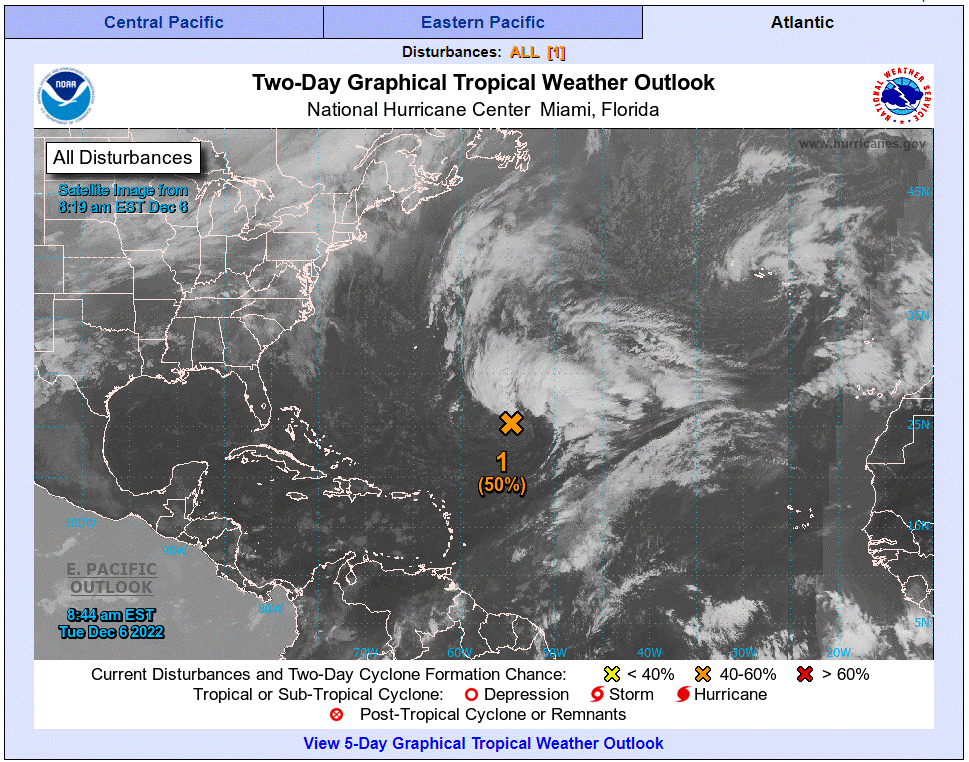
Forecasters predict that the feature will continue to strengthen in the coming days, giving it a solid chance to evolve into a tropical depression or subtropical storm as early as Wednesday or Thursday. Unlike a tropical storm, a subtropical system only features a few typically recognized tropical characteristics.
At this point, the system is not predicted to form near any major land masses. However, the feature could trigger impacts to well-traveled shipping routes in the middle of the North Atlantic Ocean. The system is also expected to be large in size, extending hundreds of miles. This means that its potential impacts may be felt well away from the storm’s center.
The rough seas are most likely to impact the Azores island chain located west of Portugal late this week. The western islands of this chain are the most at risk of experiencing strong winds and heavy rain. Cooler waters churning close to the Azores may limit the winds, however, residual energy from the system could hit portions of western Europe early next week.
The current models show a possible track of the feature through Bermuda, although it is unclear how much intensity it will retain as it crosses the Atlantic. There is also the chance that the rough surf could impact the eastern shores of Florida if the feature continues to intensify.
Although the official season for the Atlantic basin only lasts six months, the NHC confirms that there has been at least one named feature on record for every month of the year. The last time that the Atlantic basin saw a named storm develop in December was in 2007 when Tropical Storm Olga took root in the Caribbean on December 10. Olga brought strong winds and torrential rain to a large portion of the Caribbean before heading into the southern Gulf of Mexico and breaking apart.
More recently, an unnamed subtropical storm also developed near the Azores on December 5, 2013. It is more typical for off-season storms to spin up in April and May. 2022 was the first year dating back to 2014 with no named storms on the books before June 1. The year 2016 also featured a rare January hurricane when Alex formed in the northeastern Atlantic.
As is the case with this current system, most tropical features that form between the months of December and May spin around in the far reaches of the Atlantic Ocean. It is rare that these features threaten any land in the Caribbean Sea or the Gulf of Mexico.
Did you find this content useful? Feel free to bookmark or to post to your timeline for reference later.

January 21, 2024

January 19, 2024

January 18, 2024
