
Heavy Rain, Flooding, and Chance of Severe Weather Staring Down the Southern U.S.
January 22, 2024
Posted: August 28, 2023 9:45 am


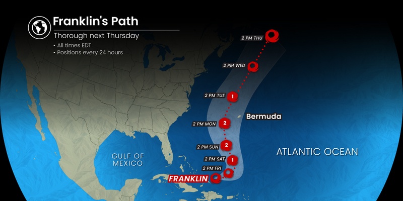
Hurricane Franklin is expected to develop into the first major hurricane of the 2023 Atlantic season as it moves closer to Bermuda in the coming hours. Here is the latest on all of the tropical activity taking shape throughout the Atlantic basin.
Forecasters with the National Hurricane Center (NHC) are predicting that Franklin will continue to intensify and will end up as the first major tropical weather event of the year with potential impacts to Bermuda, the East Coast of the U.S., and Atlantic Canada.
The storm reached the designation of a hurricane on Saturday morning. By the middle of the day Sunday, Hurricane Franklin was a Category 2 storm located a few hundred miles to the north-northeast of the Turks and Caicos. The feature will need to reach maximum sustained winds of at least 111 mph in order to take on the designation of a Category 3 storm.
Franklin’s slow movement will give it more time to lean on the warm waters of the Atlantic to intensify. A lack of wind shear will also support this development.
Franklin had dumped heavy rain and ushered in strong winds across Hispaniola earlier in the week. The island nation of Bermuda is next up on the list to see the impacts of this feature. While the models do not project a direct landfall on the group of islands, the storm is forecast to pass to the west of the region. This will translate to times of strong winds as well as rough surf conditions for swimmers and boaters.
The potentially dangerous rough surf conditions and rip currents may begin to impact the islands by Sunday. The high wind gusts up to about 60 mph and a good amount of rainfall are expected to impact the area on Tuesday and Wednesday.
Although the current models show the feature spinning to the west of the islands, there is still the chance that it could change direction and inch closer to the core of the nation. Interests in Bermuda will want to pay attention to this track in the coming hours.
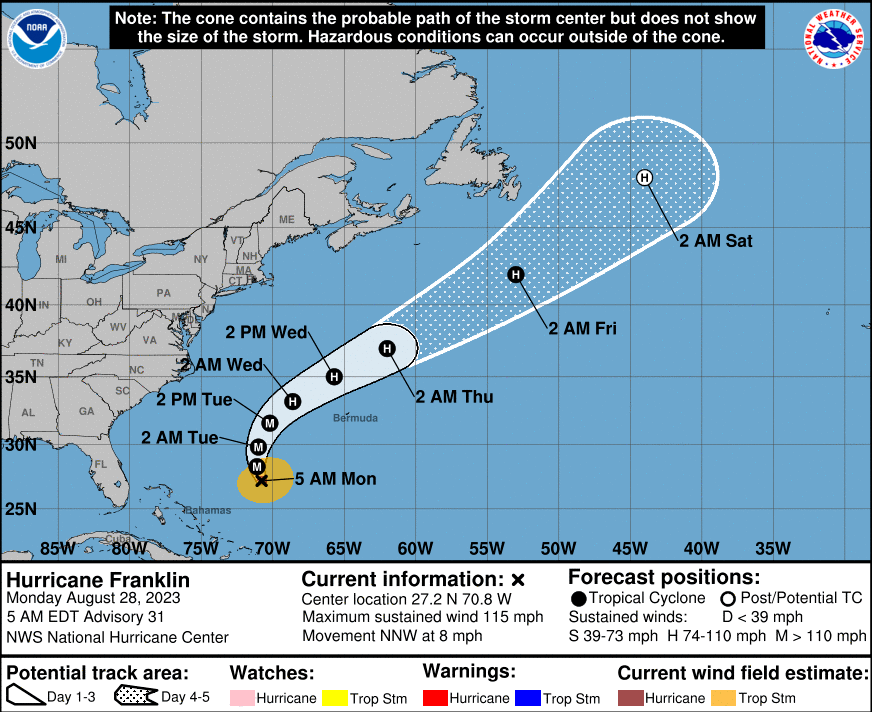
The U.S. mainland is not expected to see any major impacts from Franklin. However, the track of this storm could take it into Atlantic Canada. The nation’s easternmost province of Newfoundland is the most at risk of seeing the effects of this storm.
Franklin is projected to speed up as it moves through the Atlantic Ocean. The feature will start to lose its punch as it interacts with a separate weather maker currently over Canada.
The southwestern corner of Newfoundland should brace for rainfall amounts of 1 to 2 inches and wind gusts between 40 and 60 mph by Thursday. The eastern coastline of the U.S. will avoid any direct impacts. However, the beaches could see some rough surf conditions and strong rip currents on Tuesday and Wednesday. This is not good news for vacationers hoping to squeeze in one last beach trip this summer.
The high waves created by Franklin could create tidal flooding concerns up and down the East Coast as the Super Blue Moon rises in the sky during the middle of the week. The usual areas susceptible to this type of flooding will be the most at risk, including Charleston Harbor in South Carolina.
Hurricane Franklin is not the only threat in the Atlantic basin. Tropical Storm Idalia is forecast to turn into a hurricane shortly as it heads towards the Florida Gulf Coast. The latest models show that Idalia could bring significant impacts to the Big Bend area of the Sunshine State by Tuesday or Wednesday. Potential impacts include strong winds, heavy rain, and storm surge flooding.
What was once a tropical depression intensified into a tropical storm on Sunday morning. As of mid-day Sunday, the storm was moving to the east of the Yucatan Peninsula of Mexico heading into the exceptionally warm waters of the Gulf of Mexico. Here it is expected to strengthen further, potentially reaching hurricane status.
With landfall not expected until Wednesday, Idalia could still change course in the coming days. However, once a storm enters the Gulf of Mexico, landfall in some area is typically imminent as there is nowhere for it to exit into the open seas without impacting land.
The formation of Tropical Storm Idalia means that there have now been 10 named storms in the Atlantic this season. This is only the seventh time on record that 10 storms have taken root by August 27.
Lastly, meteorologists are keeping a close eye on two additional areas of potential tropical development in the central and eastern portions of the Atlantic. These features could develop into tropical storms by the end of the week as the peak of the Atlantic hurricane season nears closer.
Did you find this content useful? Feel free to bookmark or to post to your timeline for reference later.

January 21, 2024

January 19, 2024

January 18, 2024
