
Heavy Rain, Flooding, and Chance of Severe Weather Staring Down the Southern U.S.
January 22, 2024
Posted: August 29, 2023 1:45 pm


Idalia is now a hurricane that is expected to hit the status of a Category 3 storm prior to making landfall in or around the Big Bend region of Florida on Wednesday. Here is the latest on this life-threatening tropical weather event as it churns in the Gulf of Mexico.
Preparations and evacuation are underway in Florida as Hurricane Idalia is pushing toward the Sunshine State. The storm is forecast to intensify throughout the day, reaching the designation of a major hurricane before it makes landfall. Likely impacts include torrential rainfall, flash flooding, dangerous storm surge, strong winds, and isolated tornadoes and waterspouts.
Idalia was still a tropical storm through the day Monday, finally hitting a hurricane designation early Tuesday when it was able to capitalize on the exceptionally warm sea surface temperatures in the eastern Gulf of Mexico. As of late Tuesday morning, the storm was packing maximum sustained winds of 85 mph.
The National Hurricane Center (NHC) is predicting that the storm will continue to intensify throughout the day Tuesday, eventually reaching a Category 3 categorization. Hurricanes in this category pack wind speeds of over 111 mph. Landfall is expected to happen early Wednesday along the Big Bend region of Florida’s west coast.
Mandatory evacuations orders are now in effect for at least 10 counties in Florida. The National Guard has also been called in to assist in search and rescue efforts. Tampa International Airport closed for business on Tuesday in advance of the storm’s arrival.
Some of the impacts are already being felt in Florida. A weather station in Key West recorded a wind gust of 48 mph early Tuesday afternoon.
A number of warnings and watches are in effect for Florida and up into the southeastern U.S. This includes hurricane and storm surge warnings for a large swath of Florida’s west coast, encompassing the major metropolitan area of Tampa. Idalia is expected to also bring impacts to much of the Southeast, including Georgia, the Carolinas, and Virginia.
What is most concerning to forecasters is the likelihood that Idalia will find the necessary environmental conditions to undergo the process of rapid intensification prior to making landfall. This process is defined as a boost in maximum sustained winds of 35 mph or greater in a period of 24 hours or less.
Wind gusts near the spot of landfall are forecast to land in the range of 120 to 140 mph. These winds will almost certainly knock out power for an extended period of time as well as trigger structural damage.
Hurricane experts are also worried about the likelihood of life-threatening storm surge with Idalia. The outer wind bands of Idalia will send water up into the beaches of the Gulf Coast of Florida for hours before landfall. This push of water will supply a massive amount of storm surge as high as 15 feet to the southeast of where the storm ends up coming on shore.
The current forecast calls for a storm surge of 10 to 15 feet in an area stretching from Steinhatchee to Homosassa in Florida. Tampa Bay could experience storms surge in the range of 7 feet.
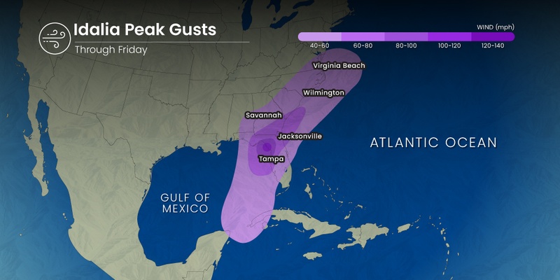
There is also a risk of tornadoes and waterspouts spinning up to the east of the hurricane eye. This means that tornadic activity is a possibility across the west-central and southwestern region of Florida and into the Florida Keys throughout the day Tuesday. By Wednesday, the highest risk of twisters will be focused on the northern and central portions of Florida and into southeastern Georgia. Communities that need to be on guard include Panama City, Cedar Key, and Mexico Beach.
As with all tropical events, the amount of moisture that will come on shore could also pose significant problems. The current forecast models are predicting widespread rainfall amounts of 4 to 8 inches in a zone from northern Florida and into the Southeast. Rainfall of this magnitude will create serious risks of flash flooding.
The bulk of the rain is expected to fall over a time period of just 12 hours. Low-lying areas will be the first to see flooding with areas surrounding larger bodies of water experiencing the threat later in the week.
The perfect storm of onshore winds and the natural impacts of the upcoming full moon will bring the storm surge to the coast opposite of the landfall location. The combination of these factors will translate to a storm surge of 3 to 6 feet in an area of the East Coast stretching from Jacksonville, Florida to Charleston, South Carolina.
Idalia’s lifespan has been marked by its erratic path through the Gulf of Mexico and over western Cuba. As such, forecasters are warning that there is still time for Idalia to jog in a different direction. The potential landfall could happen as far south as the northern edge of the Tampa Bay region and westward through Apalachee Bay.
Even those areas not in the cone of impact may see significant effects from Idalia. After coming onshore in Florida, the storm is predicted to move into the Southeast still packing high amounts of moisture and winds in the 40-mph range.
The rough surf conditions and strong rip currents have already started along the Gulf Coast of Florida. Meanwhile, parts of the Atlantic coast are dealing with these conditions due to Hurricane Franklin in this part of the basin. While Franklin is forecast to remain well off shore from the U.S., the increase in high waves has also been noted.
Did you find this content useful? Feel free to bookmark or to post to your timeline for reference later.

January 21, 2024

January 19, 2024

January 18, 2024
