
Heavy Rain, Flooding, and Chance of Severe Weather Staring Down the Southern U.S.
January 22, 2024
Posted: August 31, 2023 1:37 pm


A little after 24 hours removed from the landfall of Hurricane Idalia in Florida and the scope of the destruction is becoming more clear. Here is an update on this deadly storm.
Hurricane Idalia came on shore Wednesday morning in the Big Bend region of Florida’s Gulf Coast as a powerful Category 3 storm. The tropical weather event spent the rest of the day moving through northern Florida and into Georgia and the Carolinas, leaving a trail of destruction.
At least two fatalities are being blamed on Idalia. Two men died in separate weather-related car accidents in Pasco County, Florida.
Idalia was packing maximum sustained winds of 125 mph when it made landfall near Keaton Beach at 7:45 am EDT. The storm began to lose its wind intensity as it moved across Florida and into the Southeast. Idalia was officially downgraded into a tropical storm at about 5 pm EDT when it was spinning over the southeastern corner of Georgia. The storm moved offshore overnight and was churning out to sea near the border of North Carolina and South Carolina by Thursday morning.
Despite being out to sea, Idalia is still wreaking havoc over the Carolinas. Several flash flood warnings are in effect for this region as waterways are expected to crest in the coming hours. Wilmington, North Carolina recorded over 5 inches of rain thanks to Idalia with the outer bands of the storm still pumping in moisture to this part of the East Coast.
Forecasters are also sounding the alarm for Bermuda, warning that what is left of the storm could intensify once more and bring rain and winds to this island nation. It has been a soggy week for much of Bermuda as it got hit with the outer bands of Hurricane Franklin when the storm skirted to the north of the islands.
High winds were responsible for a good portion of the damage. A tree estimated to be 100 years old fell down onto the lawn of the Governor’s Mansion in Tallahassee, speaking to the strength of these winds. The wind was also responsible for almost 500,000 power outages in Florida and Georgia. The number of customers without power dropped to about 300,000 by late Wednesday as crews raced to restore service.
Storm surge was also a significant issue with this storm. This surge hit nearly 9 feet at Cedar Key, marking the first time that a hurricane came through the Apalachee Bay since 1935. Numerous videos came in throughout the day demonstrating the strength of this storm surge as it slammed into structures that have stood for years.
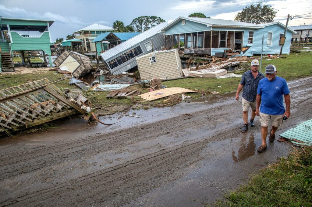
The massive storm surge also took out a group of mobile homes in Horseshoe Beach, Florida. The nearby towns of Perry and Marshall also sustained significant damage as trees fell on buildings and across roadways. For instance, the roof and walls of an apartment complex in Perry were ripped off their foundations as the winds whipped around.
The damage was not limited to Florida. Storm surge in Charleston, South Carolina reached a height that was the fifth-highest level ever recorded in this area that is no stranger to tropical weather events.
Not surprisingly, the storm also triggered a host of travel disruptions. Roughly 1,000 flights were canceled on Wednesday with an additional 2,000 delays. Tampa International Airport fully reopened on Thursday morning after being closed for much of the day Wednesday.
While it is still too early to understand the full scope of the damage, the early estimates indicate that the economic loss will come in between $18 billion and $20 billion. The silver lining is that Idalia came onshore in a part of Florida that is not densely populated. This will help keep the total damages down when compared to last year’s Hurricane Ian.
There is no rest for hurricane watchers this week as the tenth named storm of the season took root southeast of Bermuda early Thursday. Tropical Storm Jose formed at 5 am EDT packing maximum sustained winds of 40 mph. According to the National Hurricane Center (NHC), Jose is moving to the north at a slow speed of 5 mph. The storm is not expected to impact any land should it stay on this course.
In addition to Jose, another area of storms and showers near Jose could turn into a new tropical storm. There is also a disturbance spinning off the coast of Africa that could take on tropical characteristics in the coming days. You will want to stay abreast of these developments as the peak of the 2023 Atlantic hurricane season inches closer.
Did you find this content useful? Feel free to bookmark or to post to your timeline for reference later.

January 21, 2024

January 19, 2024

January 18, 2024
