
Heavy Rain, Flooding, and Chance of Severe Weather Staring Down the Southern U.S.
January 22, 2024
Posted: September 13, 2023 9:53 am


Forecasters with the National Hurricane Center (NHC) are getting a better idea about where Hurricane Lee may make its landfall in the coming days. While the current models indicate that the U.S. will avoid a direct strike, that does not mean that the country is out of the woods for potential impacts from this long-lived storm. Here is the latest on Hurricane Lee.
Hurricane Lee Likely to Strike Atlantic Canada
Hurricane Lee is forecast to hit Atlantic Canada, likely in or near Nova Scotia. However, New England and parts of the mid-Atlantic coastline may still see the impacts of this storm in the coming days in the form of heavy rain and high winds.
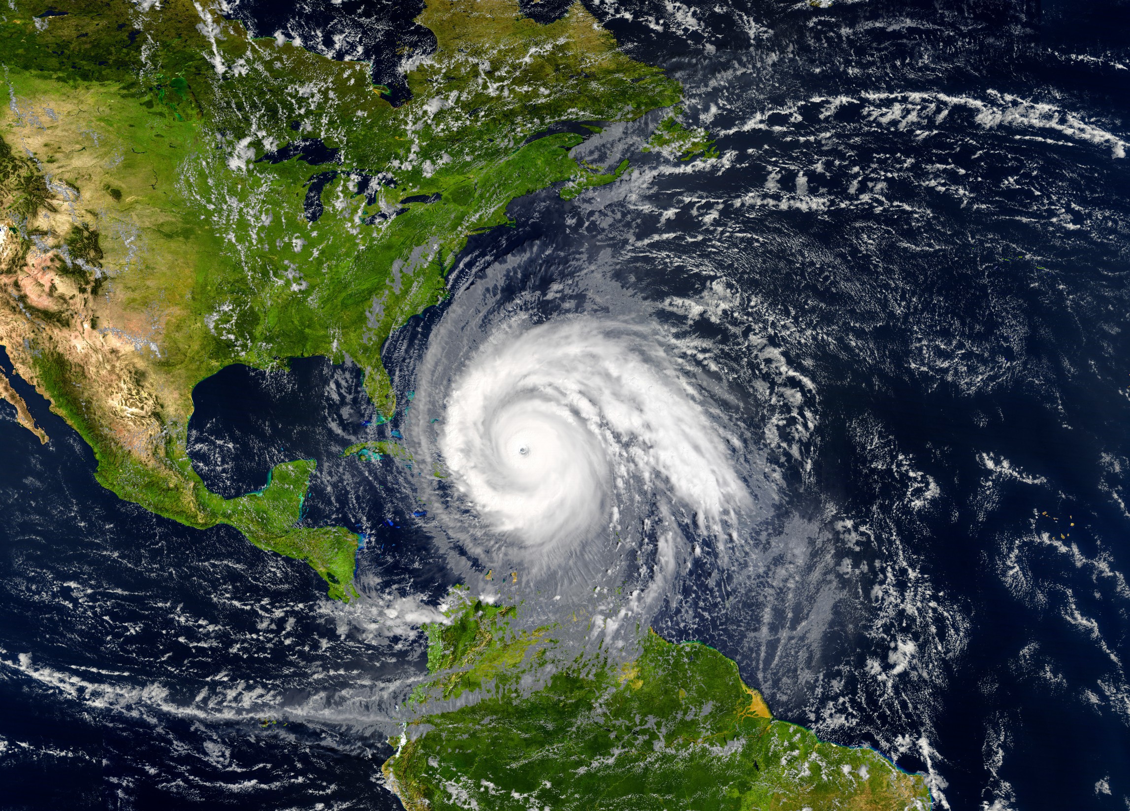
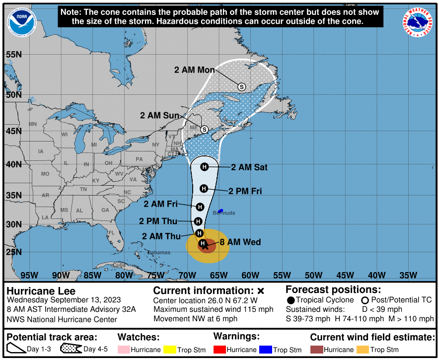
As of Wednesday morning, Lee was still a Category 3 storm with maximum sustained winds of 115 mph. The system is churning about 500 miles south of Bermuda. At its peak late last week, Lee hit the status of a Category 5 storm before weakening when it moved into cooler waters in the Atlantic Ocean.
Lee boasted sustained winds of 165 mph at its highest strength, distinguishing it as the strongest storm thus far in the 2023 Atlantic hurricane season. Experts believe that Lee will have gone on a journey of nearly 3,000 miles by the time that it comes on shore in Atlantic Canada.
Hurricane Lee to Ebb and Flow This Week
Lee is forecast to continue with its ebb and flow pattern this week. Changes to the size and scope of the eye of the storm and the upwelling of cooler water below the storm will combine with increasing amounts of wind shear to change its strength.
The storm is likely to make landfall in Nova Scotia, Canada at some point this weekend. A high pressure system spinning to the east could pair with the arrival of a potent jet stream to change this track slightly. For instance, there is still a chance that Lee could make landfall in New England or head farther east and come on land near Newfoundland and Labrador.
The exact track of the storm will influence the intensity and duration of its impacts to the U.S. and Canada. The areas to the east of Lee’s landfall will experience the worst of the storm surge and high winds. This will make this zone most susceptible to damage.
The storm surge will be less severe if Lee hits along the rockier coastline region of Maine and southern Atlantic Canada. Areas to the north and west of Lee’s landfall will see the heaviest of the rainfall, creating the risk of flash flooding.
Although Lee is not going to make a landfall anywhere south of New England, some parts of the Atlantic Seaboard may see rough surf conditions and strong rip currents. Coastal flooding is also a possibility for the Outer Banks of North Carolina and up into the southeastern corner of Virginia this week.
Moving to the north, the coastline along New Jersey and up into New England will see building offshore swells, large waves, rip currents, and minor beach erosion beginning in the middle of this week and lasting through the weekend.
Lee is forecast to lose some of its wind intensity as it moves into the much cooler waters of the North Atlantic by the end of the week. A gradual weakening could translate to a larger storm as the rain bands expand outward.
There is some degree of risk of direct impacts as far south as Rhode Island and up through eastern coastal areas of Massachusetts, the southeastern corner of New Hampshire, and central and coastal portions of Maine. For instance, Cape Cod, Massachusetts is in the bullseye to see coastal flooding this weekend.
Should Lee move farther to the west than anticipated in the coming days, there will be an outside chance of landfall in New England. This is a storm that you will want to monitor closely if you live in New England.
Impacts to Bermuda
Bermuda will see the first of the impacts this week. The storm is forecast to skirt about 100 miles west of the group of islands on Friday and Saturday. Because it will not take a direct hit, the impacts will likely be limited to tropical-storm-force winds and heavy rain. There is also a good chance of dangerous surf conditions ruining some beach plans for vacationers.
Lee will also produce sea swells as high as 30 feet ahead of the storm’s eye. This could present issues for shipping interests in this part of the Atlantic basin.
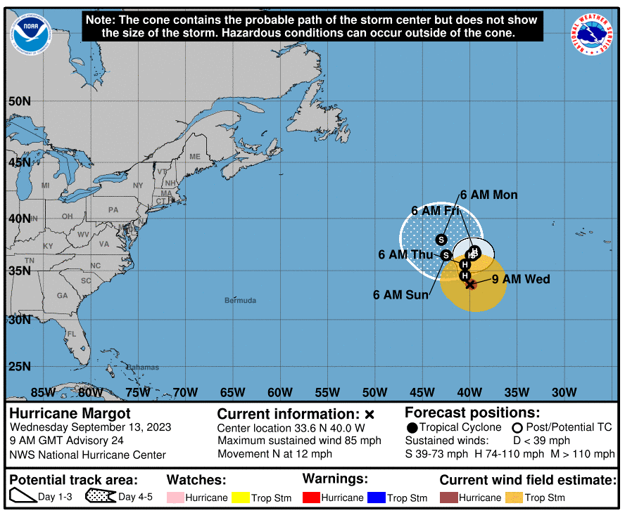
Hurricane Margot Forms
Forecasters are also keeping a watch on Hurricane Margot, a feature that intensified from a tropical storm into an official hurricane on Monday afternoon. This tropical weather event is not expected to impact land.
However, an additional tropical distance has presented itself off the coast of Africa this week. This disturbance has a high chance of transitioning into a tropical storm over the weekend as it finds the exceptionally warm waters circulating in the central Atlantic. The next name up on the list of storms is Nigel.
Did you find this content useful? Feel free to bookmark or to post to your timeline for reference later.

January 21, 2024

January 19, 2024

January 18, 2024
