
Heavy Rain, Flooding, and Chance of Severe Weather Staring Down the Southern U.S.
January 22, 2024
Posted: September 21, 2023 8:18 am


Hurricane Nigel developed what tropical weather experts have been calling a “massive eye” earlier in the week as it journeys through the Atlantic Ocean. Will this storm threaten the U.S. or any other major landmasses? Here is what you need to know about what is going on this week in the tropics.
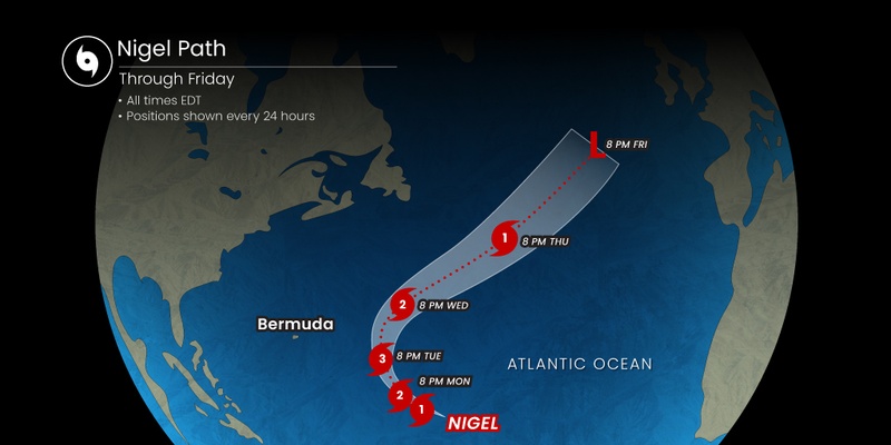
Nigel is distinguished as the sixth hurricane of the 2023 season as it moves through the central portions of the Atlantic. As of Wednesday morning, Nigel is a Category 1 storm packing maximum sustained winds of 90 mph. The National Hurricane Center (NHC) said that the storm is spinning about 650 miles to the east-northeast of Bermuda, moving at a speed of about 18 mph.
While Nigel had briefly reached the status of Category 2 storm, it weakened again and landed at a Category 1 threshold. Earlier in the week, meteorologists had predicted that Nigel could reach the status of a major hurricane, defined as Category 3 or higher. However, this window of development may be closing as Nigel moves into cooler waters farther to the north.
What is most unique about Nigel is that it has transformed into an annular hurricane, a storm that features a larger than normal eye. Annular hurricanes account for just 4% of all hurricanes. These types of hurricanes are also known for the lack of outer rain bands.
Although annular hurricanes are typically able to thrive in cooler waters because of the larger eye, they also are not as likely to strengthen considerably. Conversely, smaller eyes are generally indicative of stronger storms.
Nigel had been on a northwesterly course since it first came to life as a tropical depression last week. That projected path is starting to turn more toward the north with a northeasterly track expected in the coming days.
The change in course is being attributed to a non-tropical storm that doused the Interstate 95 corridor in the Northeast early this week. This system is working to pull Nigel to the north. Nigel is also beginning to pick up speed as it moves in this direction.
As a result of the turn to the north and the east, Nigel is not expected to bring any impact to the U.S. While Bermuda will not take a direct strike from the storm, the group of islands may experience large ocean swells. These high waves will peak on Wednesday before starting to dissipate as Nigel quickly exits this part of the basin. Bermuda is not expected to see any rain or high winds brought on by Nigel.
There is also the possibility that Nigel stays together as a tropical wind or rainstorm as it journeys through the Northern Atlantic. Should that happen, the United Kingdom may see some of these impacts this weekend. This could make for a soggy week for the UK as it is already experiencing the remnants of Tropical Rainstorm Lee.
Shipping interests in this portion of the Atlantic will also want to be aware of Nigel’s presence.
Nigel is not the only area of concern in the Atlantic basin this week. Forecasters with the NHC are also keeping an eye on an area of potential tropical development in the eastern and central portions of the Atlantic. This feature got its start as a tropical wave coming off the coast of Africa.
Of more immediate concern is a zone of potential tropical activity forming off of the coast of the southeastern U.S. This zone has been given a medium chance of taking on tropical characteristics by the end of the week. The next two names on the list for storms in the basin this year are Ophelia and Phillippe.
Even if this system does not become a tropical depression or tropical storm, it will likely bring significant amounts of moisture to the Atlantic Seaboard this weekend. This is a weather maker that you will want to keep on your radar if you have outdoor plans over the next several days.
Did you find this content useful? Feel free to bookmark or to post to your timeline for reference later.

January 21, 2024

January 19, 2024

January 18, 2024
