
Heavy Rain, Flooding, and Chance of Severe Weather Staring Down the Southern U.S.
January 22, 2024
Posted: October 20, 2023 1:01 pm


Hurricane Norma is now a major Category 3 storm as it inches closer to the western coast of Mexico. What type of impacts will this hurricane bring to Mexico and how will it affect the weather patterns of the U.S.? And what about the newly developed Hurricane Tammy in the Atlantic basin? Read on for everything that you need to know about the tropics.
Latest on Category 3 Hurricane Norma
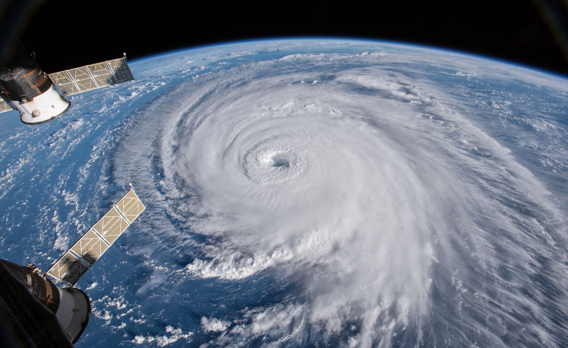
Norma underwent a period of rapid strengthening from Wednesday into Thursday morning, peaking at a Category 4 storm before it lost a bit of intensity and dropped back to the Category 3 designation. Despite its slight weakening, Norma is still going to bring life-threatening impacts to Mexico in the coming days.
As of early Friday, Norma was churning about 250 miles to the south-southwest of Cabo San Lucas, Mexico. The storm was inching along at a slow speed of 7 mph, moving in a north-northwest direction through the East Pacific Ocean.
Unlike the major Hurricane Lidia that came on shore south of Puerto Vallarta, Mexico a few weeks ago as a Category 4 monster with winds of 140 mph, Norma will begin to lose intensity before it makes landfall. The storm will weaken heading into the weekend as it moves into an area of cooler waters.
The current steering breezes over this part of the East Pacific will push Norma to the north and northwest over the next several hours. This path will bring it close to the southern tip of Mexico’s Bahamas Peninsula beginning late Saturday night and into Sunday morning.
Possibilities for Norma’s Path
Norma’s path after this weekend is still more uncertain. The position of the jet stream circulating over the western U.S. will influence if Norma impacts more than just Mexico heading into next week. For instance, if the jet stream dips to the south, it will bring up Norma and its moisture and move it the northeast into the interior portions of the Southwest and across the southern Plains. However if the jet stream does not experience this dip, the storm will likely remain near coastal Mexico until it gradually dissipates.
How the jet stream ebbs and flows this weekend across the West Coast will be something that forecasters will be closely watching this weekend. In addition to influencing the path of Norma, this weather pattern is forecast to bring cooler air to the Southwest this weekend. This corner of the West Coast has been dealing with record heat over the last week. The cold air will also be enough to support the development of snow over portions of the northern Rockies and High Plains.
What Mexico Can Expect with Norma
Before Norma will sniff the U.S., Mexico will be up first in its path. After moving onshore, the storm will weaken into a tropical storm as it moves across the interior higher elevations of northern Mexico.
Norma will deliver the usual heavy rain to its impact zone of the southern edge of the Baja Peninsula and to the west-central coast of the Mexico mainland. The moisture will trigger the risk of flash flooding and mudslides.
The winds associated with Norma will whip up the seas in the region, creating high waves and coastal flooding. All beachgoers, boaters, and shipping interests will want to stay abreast of these changing conditions and exercise extreme caution when in or near the water.
How Much Rain for the South Central U.S.?
Even if the core of Norma’s moisture does not move into the U.S. next week, much of the south-central portions of the country will see a meaningful amount of rain. This precipitation will be a welcome relief for this drought-stricken region. The ongoing drought has been responsible for historic low levels of water in the Mississippi River, negatively impacting the crucial shipping industry on this waterway as well as the drinking water supply in southern Louisiana.
Unlike some influxes of tropical moisture, this event is forecast to be spread out over a longer time period. The rate at which the rain falls will allow the dry ground time to more effectively absorb the water.
However, there is still the possibility that some zones of intense rain in a few short hours could create the risk of run-off and flooding. These concerns will be most prevalent in Oklahoma, Texas, and New Mexico. Stay tuned to this weather situation if you live in this part of the U.S.
Latest on Hurricane Tammy
The tropical activity has also not slowed down in the Atlantic basin. Hurricane warnings are now in effect for portions of the Lesser Antilles as Hurricane Tammy bears down. As of late Friday morning, Tammy was spinning less than a hundred miles east of Barbados. Tammy was offering up maximum sustained winds of 75 mph, making it a Category 1 storm. The feature is crawling along to the west-northwest where it is expected to swipe the central and northern Lesser Antilles potentially as high as a Category 2 storm.
A number of islands will be affected by heavy rain, strong winds, dangerous rip currents, and rough seas. Those in the line of fire include Anguilla, Antigua and Barbuda, Barbados, Dominica, Guadeloupe, Martinique, Montserrat, Saba and St. Eustatius, St. Kitts and Nevis, St. Maarten, St. Martin, St. Barthelemy, and the British and U.S. Virgin Islands. The storm will have the ability to bring down power lines and trees, causing power outages on a widespread level.
These impacts will begin to be felt on Friday and will linger through the weekend. There is also the possibility that Tammy could hit the status of a major Category 3 storm later in the weekend, defined as a hurricane with maximum wind speeds of over 110 mph.
What is Next in the Atlantic Basin?
Tammy will steer away from the northern Leeward Islands on Sunday even as it continues to strengthen. The wind patterns will take the feature out into the open seas of the North Atlantic.
Hurricane watchers will then turn their attention to the southwestern Caribbean Sea, the next likely area of tropical weather development. An area of low pressure centered in this part of the Caribbean could take on the characteristics necessary to spur new tropical formation next week.
Did you find this content useful? Feel free to bookmark or to post to your timeline for reference later.

January 21, 2024

January 19, 2024

January 18, 2024
