
Heavy Rain, Flooding, and Chance of Severe Weather Staring Down the Southern U.S.
January 22, 2024
Posted: August 26, 2021 11:11 am


Tropical Feature in Caribbean Could Threaten Gulf Coast
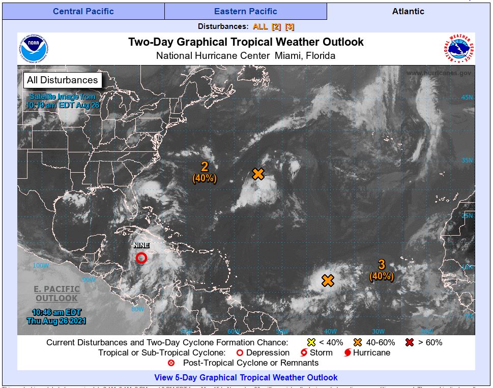
Three tropical features in the Atlantic basin are keeping experts at the National Hurricane Center (NHC) busy this week. While the Northeast is still cleaning up from the impacts of Tropical Storm Henri, the Atlantic is getting busy once again as it approaches the peak of hurricane season. Here is the latest on these three tropical features.
The system that is most pressing as of Wednesday is a tropical wave churning over the southwestern Caribbean Sea. Hurricane watchers predict that this disturbance is ripe for further development over the next few days. The system is predicted to move near or over the Yucatan Peninsula by Saturday. This is an area that was recently pummeled by Hurricane Grace.
Designated as Invest 99L by the NHC, this feature has been delivering showers and moderate winds to the northern coast of South America over the last few days. While 99L is positioned unusually to the south, there is still a good chance that it will organize and pose a threat to Central America and beyond.
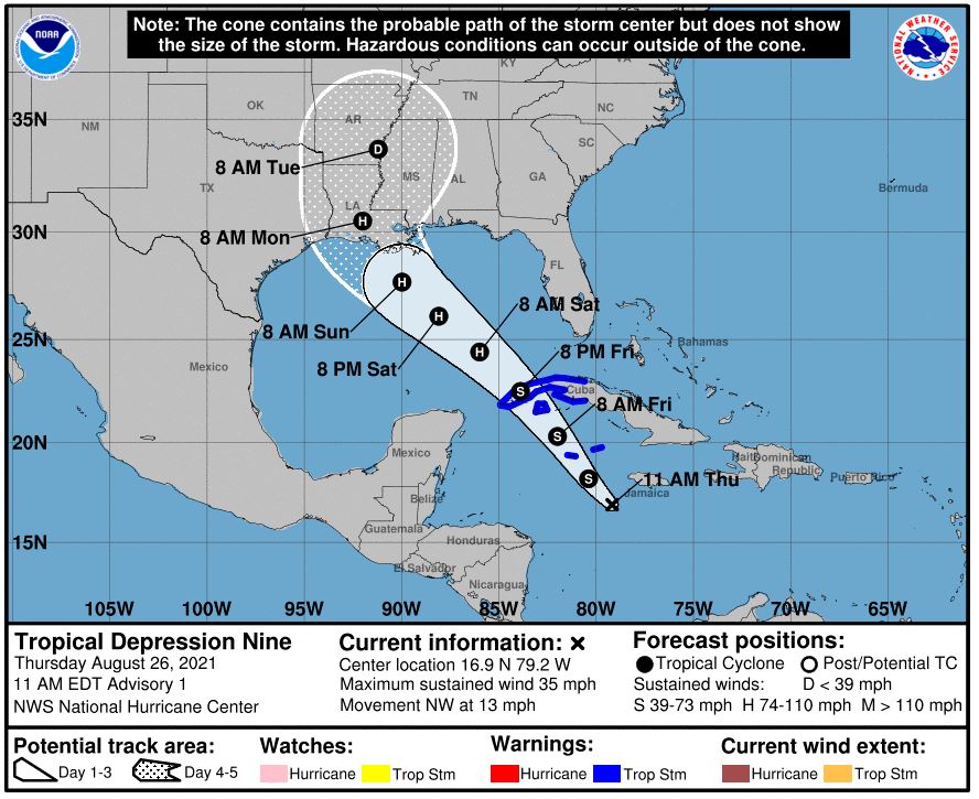
Meteorologists do not expect this system to strengthen much over the next 48 hours due to increasing amounts of wind shear in its path. However, 99L could still bring showers and severe weather to Jamaica and the Cayman Islands in the following days.
After moving over the Yucatan Peninsula, it is likely that the disturbance will move into the western Gulf of Mexico by Sunday. Here it will encounter favorable environmental conditions for further development. The NHC puts the odds at 80% that this feature will intensify into a named storm over the next five days.
This could spell trouble for South Texas or the Gulf Coast depending on the trajectory of the storm. An area of high pressure set up over the central US could serve to block the storm from moving north to the Gulf Coast. However, if this system begins to weaken, the storm could grow rapidly in the Gulf of Mexico with a path headed straight for the Gulf Coast.
In addition, sea surface temperatures in the Gulf are currently registering 1-2 degrees Celsius above average for this time of year. This could serve to intensify the storm if it moves deep into the Gulf after crossing the Yucatan.
Over in the central Atlantic, a broad trough of low pressure is delivering a number of showers and thunderstorms to the open waters. This area is currently located about 800 miles southeast of Bermuda. Unfavorable upper-level winds will slow down the development of this feature over the next 48 hours. However, the environmental conditions needed for further development are expected to be in place later in the week. As such, the NHC has put the chances that this forms into at least a tropical depression in the next five days at 80%.
A cold front is set to move through the western Atlantic in the next few days. This weather system will determine if the current tropical low will threaten Bermuda.
A third feature is positioned in the far eastern tropical Atlantic, located several hundred miles from the Cabo Verde Islands. Because this feature is located so close to the equator, it is encountering a variety of physical forces that will likely inhibit its development in the coming days. As of mid-day Wednesday, the NHC said it only has a 20% chance of forming into a named storm in the next 48 hours. This number jumps to 30% for development over the next five days.
The next three names on the 2021 Atlantic list are Ida, Julian, and Kate.

January 21, 2024

January 19, 2024

January 18, 2024
