Heavy Rain, Flooding, and Chance of Severe Weather Staring Down the Southern U.S.
January 22, 2024
Posted: September 1, 2023 9:43 am


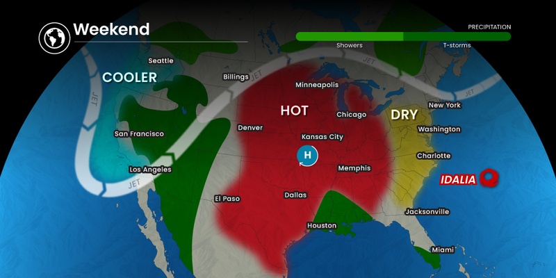
As the calendar is turning from August to September, the temperatures are turning from unseasonably cool to unseasonably warm. Do not break out those sweaters quite yet. Some of the hottest days of the summer for the Northeast are on tap for the first weekend of September. Here is a look at what is on tap for weather for the long weekend.
The Labor Day holiday weekend traditionally marks the end of the summer. But it will still feel like summer in the Northeast with a heat wave on tap for many areas that will send the mercury to its highest levels of the year.
A mass of cool Canadian air has kept the temperatures roughly 10 degrees below average in the Northeast this week. This will continue through the end of the week, however, a change is in store.
Overnight lows have been particularly chilly in the higher terrains of New York’s Adirondacks and the central and northern Appalachians. Readings have dropped as low as the upper 30s in this part of the country over the last few nights. This trend will continue into Saturday morning before the temperature begins its upward trajectory.
Cooler temperatures will also be the norm for the populated Interstate 95 corridor into Saturday. As the weekend gets started, heat is expected to build over the Plains states and make its way to the East Coast. It will be a good idea to dress for hot weather if your weekend plans call for a high school or college football game.
How warm will it get? The temperatures will climb into the upper 80s and low 90s in many of the region’s most populated cities, including New York City. The Big Apple has yet to experience an official heat wave this summer, defined as three consecutive days with readings at 90 degrees or higher. While New York City did not see any temperatures in the 90s during the entire month of August, the forecast for next week is calling for the mercury to come close to this benchmark on a few days.
It was July 28 the last time that New York City saw temperatures climb into the 90s. The historical average for the city during the first part of September is right around 80 degrees. The record high reading during the summer of 2023 for New York City topped out at 93 degrees, a mark that was set on July 5.
New York City is not the only big metropolitan area in the Northeast that has yet to experience a heat wave this summer. Pittsburgh has only seen two days this summer with a reading of 90 degrees or higher. While it may be a stretch for the Steel City to reach this threshold this weekend, it will come quite close beginning on Sunday and lasting through Wednesday.
Farther south, Washington, D.C. and Baltimore have seen several days in the 90s this summer, however, neither city has eclipsed the century mark. The same is true for Philadelphia.

The weekend weather will remain cool for New England. Depending on the track of the remnants of Idalia, the heat could stay away for much longer. However, if Idalia is able to intensify as it churns over the western Atlantic this weekend, it could bring a surge of warmer air into New England early next week. While it is still too early to tell how much of an impact Idalia will have this far north, there is a chance that temperatures could surge into the 80s early next week for Boston and beyond.
The increase in tropical activity in the Atlantic basin will undoubtedly create a number of beach hazards this weekend. In addition to Idalia, what is left of Hurricane Franklin will also increase the threat of strong rip currents and dangerous surf conditions well into next week.
This is not good news for people hoping to make the most of the warmer temperatures with a trip to the beach to close out the summer season. You will want to pay heed to any posted warnings or lifeguard instructions.
The Labor Day weekend provides a good time to reflect on the summer and its weather patterns. Although the Southwest and the Midwest sizzled, it was an unusually cool summer for the Northeast and New England. Frequent waves of cool air pushing down from Canada kept temperatures about 2 – 3 degrees below normal for this corner of the country in June.
June was also marked by the arrival of wildfire smoke from Canada. This smoke worked to create a haze that blocked out the heat of the sun and created poor air quality conditions, putting a damper on the usual summer outdoor activities.
New England was distinguished for its wetter than usual summer. Rainfall amounts came in at almost twice the average for many communities for the summer overall, largely due to the massive amounts of moisture that fell on the region in July.
Did you find this content useful? Feel free to bookmark or to post to your timeline for reference later.

January 21, 2024

January 19, 2024

January 18, 2024