
Heavy Rain, Flooding, and Chance of Severe Weather Staring Down the Southern U.S.
January 22, 2024
Posted: June 22, 2023 6:05 pm


Tropical Storm Bret is churning closer to the Caribbean, prompting a hurricane watch for this part of the Atlantic basin. Here are the latest developments surrounding the second named tropical storm so far this year as well as a look into what is coming in behind Bret.
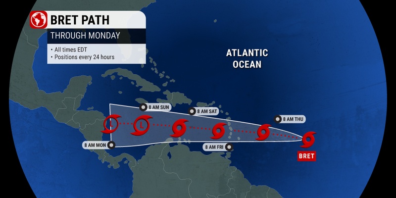
As of late Thursday morning, Tropical Storm Bret was located in the eastern Caribbean, spinning about 130 miles east-northeast of Barbados. The storm is moving along at a speed of 14 mph.
The Air Force Reserve Hurricane Hunter aircraft data indicated that the storm intensified on Wednesday night, hitting maximum sustained wind speeds of 70 mph as it inched closer to the Lesser Antilles. Wind speeds need to eclipse 73 mph to designate the feature as a Category 1 hurricane.
However, forecasters with the National Hurricane Center (NHC)say that the storm is not likely to continue its intensification due to a number of inhibiting factors. For instance, an increase in the amount of wind shear in the path of Bret is expected to break up the storm in the coming days.
It is still possible that Bret will hit the status of a Category 1 hurricane prior to moving into this large area of wind shear. But this strengthening is likely to reverse as it moves to the west across the Atlantic.
Local officials issued a hurricane watch and a tropical storm warning for St. Lucia, located on the eastern edge of the Caribbean. The island of Barbados is also expected to see wind speeds of 40 to 60 mph on Thursday as Bret moves just to the north. While Barbados is not expected to take a direct hit from the storm, the island will see a good amount of moisture out of Bret’s outer rain bands.
Late Thursday and early Friday will bring the strongest winds in areas such as St. Lucia and Martinique. Peak gusts could climb to up to 100 mph. Rainfall amounts are predicted to land at about 1 to 2 inches in Barbados with a maximum of up to 10 inches across the Lesser Antilles stretching from Guadeloupe to St. Lucia.
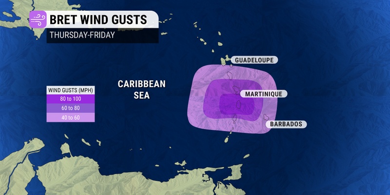
These impacts will trigger the chance of flash flooding and power outages. In addition, mudslides are a possibility at the higher elevations.
Bret is forecast to move over the open waters of the Caribbean Sea heading into the weekend where it will meet less favorable conditions. This will translate to the storm losing its wind intensity and becoming a tropical depression.
Hispaniola and Jamaica will be under the gun for tropical downpours on Saturday and Sunday even if the storm transitions to a depression and becomes less organized.
Right on the heels of Bret is another tropical depression that formed early Thursday. The NHC has dubbed this feature Tropical Depression Four. The storm system is located about 1,270 miles east of the Lesser Antilles, moving to the west-northwest at 15 mph. The depression is packing maximum sustained winds of 35 mph as it continues to become more organized and develop a distinct center.
The system is forecast to intensify into the category of a tropical storm by late Thursday. However, this feature is not expected to impact land as it moves to the north of the Greater Antilles. The feature will be named Cindy should it develop into a tropical storm by hitting wind speeds of at least 39 mph. Because of wind shear in its path once it reaches the Caribbean, the feature is not expected to reach hurricane strength.
The tropical activity in the East Pacific is also predicted to heat up early next week as several organized waves churn through this part of the basin. For instance, an area of low pressure expected to take root off the southern coast of Mexico in the coming days could develop into a tropical depression. The next name up for the 2023 East Pacific season is Adrian.
Did you find this content useful? Feel free to bookmark or to post to your timeline for reference later.

January 21, 2024

January 19, 2024

January 18, 2024
