
Heavy Rain, Flooding, and Chance of Severe Weather Staring Down the Southern U.S.
January 22, 2024
Posted: March 3, 2023 2:46 pm


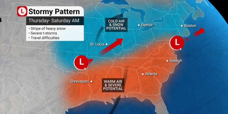
The multi-day severe weather event is continuing its wrath on Friday, with the storm cells moving to the east across the Ohio Valley and beyond. The eastern half of the U.S. is set to see more severe thunderstorms and flooding rain along with gusty winds. Those on the northern edge of the storm are dealing with the potential of heavy snow. Here is the latest on this developing situation.
Winds are forecast to whip up in an area stretching from eastern Texas up through western New York. Gusts could hit a speed of 60 mph with regions such as the Gulf Coast and the Great Lakes in the impact zone. The gusty winds could make for a day of turbulence in the skies.
The weather is already being blamed on hundreds of flight disruptions. Nearly 400 flights were canceled at Dallas-Fort Worth International Airport on Thursday, including a ground stop in effect during the evening hours because of severe storms approaching the area. Travelers on Friday are already dealing with more disruptions. By Friday morning, there were already over 80 flights cancelled and dozens more delayed.
Snow will be the problem causing problems for travelers in the north. The major airport hubs in Chicago and Detroit will be ground zero for these disruptions by the evening hours. Do not forget to check your flight status before heading to the airport if you are flying into, out of, or through any of these hubs.
At least one fatality is being blamed on the severe weather in Mississippi. Gov. Tate Reeves announced the death on Twitter, confirming that a tree fell on a vehicle in Yazoo County.
By mid-morning, the storms were racing eastward, putting the city of Nashville in the crosshairs. The main threats associated with this line of storms include damaging winds, torrential rain, and lightning strikes. Wind gusts of over 60 mph were reported near the border of Mississippi and Alabama. Local officials are asking people to shelter in place as the storms move through the region.
A tornado watch is also in effect for eastern Tennessee, the northeastern corner of Alabama, and northwestern Georgia.
Kentucky Gov. Andy Beshear declared a state of emergency for his state on Friday morning due to the impending storms. Beshear said that the declaration will free up resources and mobilize the National Guard so that they can respond quickly to any developing weather situation.
Meanwhile, it was widespread flooding that was the story of the day Friday in a large area stretching from eastern Oklahoma and into Ohio. Heavy rain that fell on the region on Thursday triggered the flooding. Roads were impassable in parts of southern Illinois, Missouri, and western Kentucky due to the high water. The National Weather Service (NWS) is cautioning that the flooding risks will remain in effect through at least Sunday as the water moves downstream and brings some rivers and streams to their capacity.
The NWS is sending out a damage assessment team to Hopkins County, Texas, located to the east of Dallas, after reports of a tornado on Thursday night. Residents in the town of Pickton reported a twister amidst the stormy conditions. Wind gusts of up to 80 mph were reported near Dallas on Thursday evening.
Authorities reported a likely tornado in Jefferson, Texas on Thursday. Tornado spotters also reported a twister south of Shreveport, Louisiana at about the same time.
A number of winter storm watches and warnings are now in effect through early Saturday for much of the northern U.S. The watches encompass a large part of Illinois, Indiana, and Michigan. Watches and warnings in the Northeast are in effect for northern New York state, Massachusetts, Vermont, New Hampshire, and Maine. These warnings will hang around longer, not set to expire until late in the day Saturday.
Some school districts in the Chicago area preemptively called a snow day on Friday with up to 6 inches of new accumulation in the forecast. The snow is predicted to intensify in the afternoon and evening hours, making for a dicey commute home. This could be the largest snow event of the season so far for the Windy City by the time that it winds down early Saturday.
Did you find this content useful? Feel free to bookmark or to post to your timeline for reference later.

January 21, 2024

January 19, 2024

January 18, 2024
