
Heavy Rain, Flooding, and Chance of Severe Weather Staring Down the Southern U.S.
January 22, 2024
Posted: May 16, 2023 9:56 am


It is going to be a week of varied weather along the East Coast, including the chance of frost and freezes in some parts and summer like heat elsewhere.
Here is a detailed look at what you can expect in the coming days for the eastern half of the U.S. and how the weather pattern will change as the week goes by.
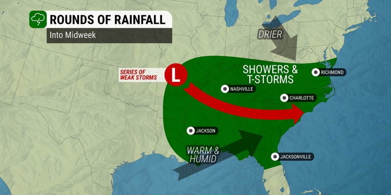
The start of the work week is bringing soggy conditions to a large swath of the Southeast and the mid-Atlantic. The storms will come into the region from the central Plains, triggering multiple rounds of rain showers and potential thunderstorms in an area stretching from Missouri into Virginia.
The impact zone will also expand down into the Southeast, reaching as far as the Gulf of Mexico.
The storm cells may turn severe as they move across the central Appalachians on Tuesday and Wednesday.
Risks associated with this weather maker include strong winds, isolated tornadoes, and torrential rain. Kentucky, Tennessee, Virginia, and North Carolina will be in the bullseye for the worst of the impacts.
Tuesday afternoon and evening will be the most likely time period for widespread storms. The severe weather could reach as far south as Jacksonville, Florida and head as far north as Pittsburgh, bringing a large swath of the Atlantic Seaboard into the fold.
The potential of heavy rain is good news for areas of northern Virginia and Maryland, a part of the country that is still under the designation of abnormally dry conditions or a moderate drought. However, forecasters are unsure if the moisture will track this far north due to a mass of dry air currently anchored over the mid-Atlantic.
This dry air will move into the Ohio Valley by late Wednesday before making its way into the mid-Atlantic and down into the Southeast the following day. This will set up a period of a day or two of dry conditions before the next chance of rain moves in just in time for the weekend.

While the mid-Atlantic and Southeast are dodging rain showers, the Northeast will remain largely dry and warm. There is a chance that some rain could sneak up into the Adirondacks in upstate New York and up through New England on Tuesday, however, these rain showers will be limited in duration and intensity.
Dry and cooler air is forecast to move into the Northeast by Wednesday, sending the mercury to lower levels through Thursday. For instance, New York City can expect high readings in the upper 60s on Wednesday and Thursday before the temperature begins to climb again.
It may get cold enough on Wednesday night for some parts of the Northeast to see a frost or a freeze. This threat will be centered on northern portions of New England and upstate New York. The northeastern corner of West Virginia may also wake up to frost on the ground on Thursday morning.
The arrival of drier air will also raise the risk of wildfires in the Northeast. Strong winds picking up on Tuesday and Wednesday will raise this risk further. Areas that are dealing with dry grass and brush are the most vulnerable to these dangers.
The southern portion of New York and New England should be mindful of this threat through Wednesday when the winds will begin to die and high pressure moves into the region.
Warmer conditions will be on tap to close out the week. The change will be most noticeable in the Northeast with an abundance of sunshine in the forecast.
While temperatures will be warmer than they were to start the week, the mercury will still be hovering around the historical average for the middle of May. This translates to readings in the mid 70s for New York City with cooler temperatures in the mid 60s into New England.
Did you find this content useful? Feel free to bookmark or to post to your timeline for reference later.

January 21, 2024

January 19, 2024

January 18, 2024
