
Heavy Rain, Flooding, and Chance of Severe Weather Staring Down the Southern U.S.
January 22, 2024
Posted: March 31, 2023 12:55 pm


The weather will be no joke on April Fool’s Day in the Northeast. The storm system that is stirring up trouble to close out the work week in the central U.S. will move to the east on Saturday, bringing a host of potentially dangerous and windy weather conditions.
In addition to widespread rain and thunderstorms, the storm will also bring high winds to the region. You can expect unseasonably cold air to filter in behind the moisture, impacting a large part of the Eastern Seaboard and beyond. Ahead of the cold front, residents should brace for the possibility of showers and thunderstorms. This is most likely to take place beginning mid-day Saturday. Cities in the impact zone will include New York City, Philadelphia, and Washington, D.C.
The threat of the severe weather will eventually extend as far south as northern Florida and as far north as southwestern New England. Air travelers will want to keep abreast of developing conditions as these storms could bring about ground stops in some of the biggest hubs in the region.
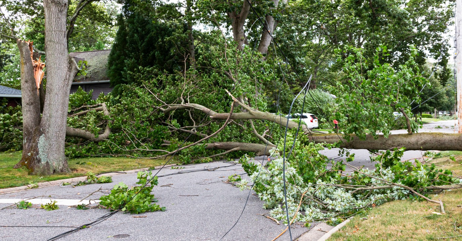
How windy will it be? Forecasters are predicting widespread windy gusts up to 60 mph. Some gusts may exceed 70 mph in an area stretching from Ohio to West Virginia, including parts of Virginia, Pennsylvania, and Maryland. Winds of these speeds will approach hurricane-force standards.
These high winds will almost undoubtedly bring down tree branches and trigger power outages. Wooded areas will be particularly dangerous with the risk of tree limbs coming down.
It will not be a great day to get outside for those pre-Easter weekend activities. This is this weekend in which many communities hold egg hunts and other events to celebrate the arrival of spring. This is also the full opening weekend for Major League Baseball. The inclement weather may cause some delays for these games.
The mercury will drop significantly as the storm begins to push out into the Atlantic Ocean and up into Canada. Temperatures will drop sharply by Saturday evening in places such as New York City and Washington, D.C., falling from highs in the 70s to the 50s by the evening hours.
There is a chance that some of the moisture may still be lingering when the cold air pushes through. This could translate to rain showers transitioning to snow showers for a brief time on Saturday afternoon and evening. The most likely places for this to happen will be across northeastern Ohio and northwestern Pennsylvania and into western and northern New York state and northwestern New England. A few inches of accumulation is not of the question in this zone, particularly if the lake-effect snow machine is able to get going.
Although it will be chillier on Sunday when compared to Saturday, it will still be the nicest day of the weekend thanks to the drier conditions. The wind may still be causing issues in the mid-Atlantic and the central Appalachians early in the day. You can expect these winds to linger through the day farther to the north in upstate New York and across New England.
Looking ahead, it will become warmer throughout the eastern half of the country early next week. However, a large portion of the central U.S. may be under the gun for more winter weather with a new storm system on the way. Stay tuned to the forecast to see how this developing weather situation may impact your week.
Did you find this content useful? Feel free to bookmark or to post to your timeline for reference later.

January 21, 2024

January 19, 2024

January 18, 2024
