
Heavy Rain, Flooding, and Chance of Severe Weather Staring Down the Southern U.S.
January 22, 2024
Posted: April 21, 2022 10:28 am


Is Winter in the Past or is it Poised to Make Another Appearance?
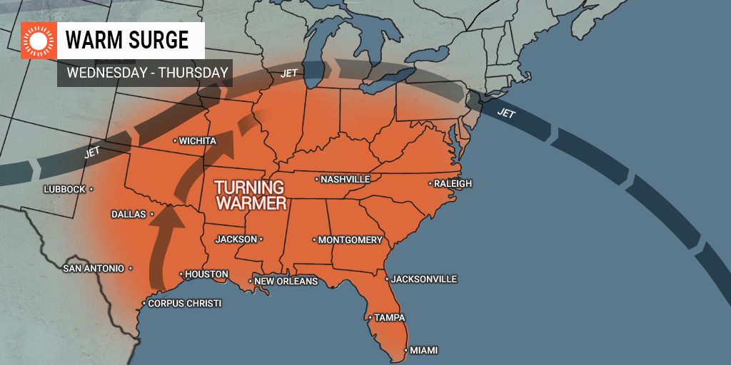
If you are tired of the cold temperatures and snow ruining your springtime fun, you may be in luck if you live in the Midwest, the central Appalachians, the mid-Atlantic, and New England. A stark warmup is on tap for this part of the country as the storms that have been impacting the region this week finally push off shore. As the jet stream retreats to the north, the cold air will exit along with it.
This change in the jet stream pattern will bring in warmer conditions that feel more like late spring in some areas. By the weekend, the Chicago metroplex is forecast to be approaching a high of 80 degrees, marking its highest mark of the year.
The mercury is also expected to soar in cities such as Detroit, St. Louis, and Indianapolis with temperatures in the high 70s and low 80s for most of the region.
However, along with the warm temperatures will come an increased chance of rain and thunderstorms on both Saturday and Sunday. The same storm system that is moving in from the west to push the jet stream to the north will also bring a significant amount of moisture with it. The severe weather will likely fire up on Friday across the Plains states before moving into some parts of the Midwest on Saturday.
The warmup will happen even more quickly on the East Coast as the storm that dumped inches of snow in some parts of the interior Northeast rushes off into the Atlantic. The warm April sunshine will quickly melt the snow that is on the ground as warm air floods into the area.
The temperature readings will settle into the 60s in Boston and New York City by Friday, finally feeling more like spring after the unseasonably chilly week. It will be even warmer in Philadelphia, Baltimore, and Washington, D.C. with highs in the 70s to close out the work week.
Unlike the warmup in the central states, this warming trending out east will run into a few roadblocks. Namely, a cold front is predicted to move to the southeast on Friday and slow down over some areas of the mid-Atlantic and central Appalachians by Saturday.
Those areas located to the north and the east of this front will see a halt in the warming trend with some temperatures actually trending downward again. However, areas to the southwest of the frontal zone will continue to bask in the warmth. For instance, while temperatures may not even reach 60 degrees in New York City on Saturday, it will be well into the 80s in cities in the mid-Atlantic such as Raleigh, North Carolina.
This pattern will continue through the remainder of the weekend. The cooler air mass will stay put along the coast of New England while the warm air encroaches back into the central Appalachians. Some parts of Pennsylvania may even see readings near 80 degrees by the close of the weekend.
Do not let this dramatic warmup fool you. Forecasters are warning that there are no signs in the long-range forecast that signal that summer is right around the corner. It is likely that there will be more cold snaps heading into the first half of May. While every passing day brings a lesser chance of snow or wintry precipitation, this cannot be completely ruled out yet. At the very least, a great majority of the northern tier of the U.S. will be looking at the strong possibility of more frosts or freezes to thwart those early spring gardens.
For instance, there is yet another winter storm system in the forecast for some areas of the Dakotas this weekend with the potential of another snow maker for the interior Northeast to kick off the month of May.
Did you find this content useful? Feel free to bookmark or to post to your timeline for reference later!

January 21, 2024

January 19, 2024

January 18, 2024
