
Heavy Rain, Flooding, and Chance of Severe Weather Staring Down the Southern U.S.
January 22, 2024
Posted: October 21, 2022 10:41 am


Parts of Mexico are bracing for another tropical storm strike as Roslyn forms in the East Pacific. But what about the Atlantic basin? Here is the latest on the tropics heading toward the end of October.
Tropical Storm Roslyn was distinguished as the 17th named system in the East Pacific Ocean when it formed on Thursday. Roslyn is the first named feature to pop up in this part of the Pacific since Hurricane Julia came over from the Atlantic Ocean. While Tropical Storm Paine was more recent, this system never threatened any land masses.
Forecasters are predicting that Tropical Storm Roslyn will head toward the western coast of Mexico in the coming days, bringing heavy rain and strong winds that also lead to the potential of dangerous storm surge flooding.
The feature will encounter warmer ocean waters in the short term, making it more likely that the storm continues to intensify. In addition, low levels of wind shear will also contribute to the storm’s ability to grow stronger.
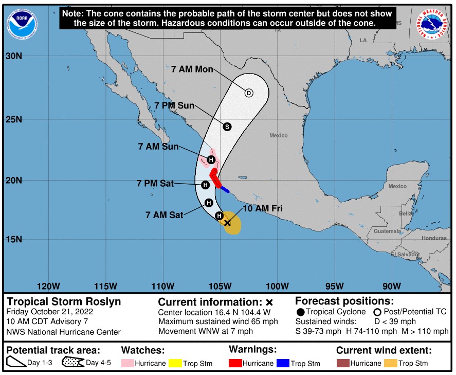
Roslyn is predicted to travel parallel to the southern coastline of Mexico for a few days before it makes a turn to the northeast. Assuming it stays on this path, Tropical Storm Roslyn will slam into the states of Jalisco, Nayarit, and Sinaloa by the end of this week or early next week.
Because of the favorable environmental conditions, experts are predicting that Roslyn may strengthen into a Category 2 hurricane prior to making landfall. A storm of this magnitude packs maximum sustained winds of up to 110 mph.
This part of the Mexico coastline is forecast to be hammered with heavy rain over the weekend just as the storm makes its turn to the northeast. Unfortunately, this is the same area that also experienced heavy rain from Hurricane Orlene just a few weeks ago.
Impacts from Roslyn
The heavy rain could trigger flash flooding, mudslides, and more. Additionally, the strong winds expected with Roslyn could cause widespread power outages and structural damage. Prior to landfall, residents along this stretch of the Mexico coastline need to be alert for dangerous rip currents and rough sea conditions over the next several days.
Roslyn will likely fall apart as it moves over the higher terrains of Mexico by early next week. However, some of the leftover moisture and energy from the system may migrate into the south-central U.S. by the middle of the week.
This moisture left from Roslyn may merge with a new storm expected to come down from the Rocky Mountains. The combination could deliver rain to the drought-stricken central Plains and down into Texas.
What About the Atlantic Basin?
While the East Pacific Ocean is heating up once again, it has been relatively quiet over the Atlantic basin over the last few days. Forecasters with the National Hurricane Center (NHC) are monitoring a rainstorm that could take on tropical characteristics of a tropical feature in the coming days just off the southeastern corner of the U.S. However, it is unlikely that this feature finds the conditions it needs to deliver more than just a good soaking and gusty winds to the Atlantic Seaboard.
The official end of the Atlantic hurricane season is November 30, meaning that the bulk of the activity should be behind the U.S. and Caribbean. A high amount of wind shear circulating in this corner of the Atlantic should temper activity through the end of October. Forecasters are warning that the beginning of November could bring a greater chance of tropical development.
It is important to keep in mind that you have to go back to 2018 to find the last time that the Atlantic basin did not see any tropical activity during the month of November. Since that time, the eleventh month of the year has seen at least one named system. November 2020 was particularly active with two Category 4 hurricanes slamming into the coast of Nicaragua.
Did you find this content useful? Feel free to bookmark or to post to your timeline for reference later.

January 21, 2024

January 19, 2024

January 18, 2024
