Heavy Rain, Flooding, and Chance of Severe Weather Staring Down the Southern U.S.
January 22, 2024
Posted: May 24, 2023 3:00 pm


While the Northeast will likely stay mostly dry for the upcoming Memorial Day weekend, it could be a different story for parts of the mid-Atlantic. Forecasters are warning that a change in the weather pattern will bring the rain that has been infiltrating the Southeast up into the mid-Atlantic in the coming days.
Here is what you need to know as you look ahead to the holiday weekend.
Before the chance of moisture moves in, the interior Northeast will be dealing with the threat of a frost or a freeze as cooler temperatures pervade. This cool air has come into the region as the jet stream continues with its southward dip.
Not only has this dip brought in cooler temperatures but it has also cut off moisture coming up from the Gulf of Mexico and across from the Atlantic Ocean.
Forecasters are predicting that a change in the weather will set up a clash between a mass of dry air in the Northeast and cloudier and wetter conditions to the south. A shift in this pattern could send some of the moisture up to the north, however, that likelihood is still in flux.
The position of the jet stream will determine who may be dealing with a rainout for the holiday weekend. If the jet stream tracks farther to the north, more moisture will be allowed in from the Atlantic Ocean. But if the zone of high pressure remains intact, the storm will likely keep its position to the south.
What forecasters are still unclear about is where the dividing line between the two competing patterns will set up in the coming days.
The most likely scenario is that three separate weather patterns will be in place across the eastern half of the U.S. this weekend. Wet and cool conditions are expected in a zone from the Carolinas up through southern portions of Virginia.
The area stretching from Washington, D.C. into western Maryland and the rest of Virginia will see the chance of intermittent rain with the highest chance of moisture slated for the latter half of the weekend.
Areas through New England, upstate New York, and northern Pennsylvania are forecast to remain mostly dry. This would translate to a pleasant kickoff to summer for this corner of the country, including the major cities of Boston and New York City.

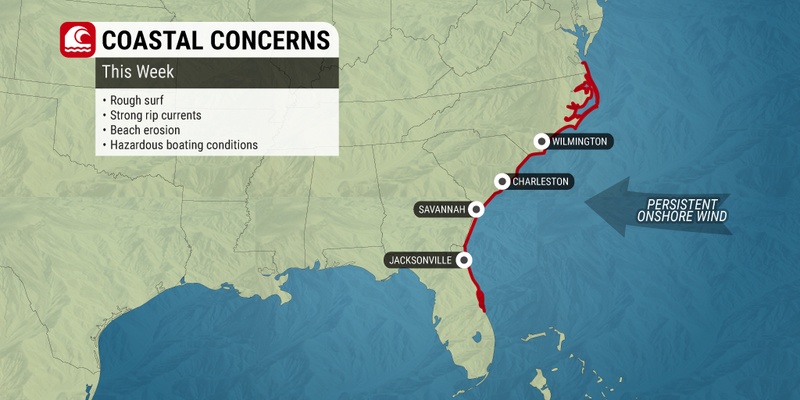
The prospect of outdoor activities for the mid-Atlantic beaches is not as promising. There is the chance that the storm system in the South could take on some tropical characteristics. Beaches in the area from the Delmarva Peninsula down into the Carolinas could see windy and wet weather.
Rough surf may be a major hindrance for beachgoers along the Carolina coast, particularly if a homegrown tropical feature forms off in the Atlantic in this region.
Before the weekend arrives, the interior Northeast will be under a threat of chilly air that could create freeze or frost conditions. The dry weather and lack of overnight clouds is paving the way for downright cold temperature readings after the sun goes down.
Temperatures are predicted to fall below freezing early Thursday morning across New England the northern tier of New York state. The presence of wind may prevent frost from forming.
Another round of cold air will move in again late Thursday and into early Friday. A lack of winds will translate to a higher chance of frost for New England by Friday morning.
This frost could dip as far south as northern Pennsylvania and into the Hudson Valley of New York. You will want to check your local forecast and take any necessary steps to protect sensitive plants and flowers.
Although the Memorial Day weekend is certainly an inopportune time to see rain, there is no doubt that this moisture is needed for much of the eastern U.S. The long-term forecast indicates a drier pattern on the horizon, meaning that this may be the only chance in some time for this region to pick up some crucial moisture.
The long-range forecast is predicting a series of cold fronts coming down from Canada in the coming weeks. While some of these fronts will raise the risk of sporadic rain and storms, it is not predicted to be enough to produce steady precipitation. This is bad news for a part of the nation that has been dealing with drought conditions.
Did you find this content useful? Feel free to bookmark or to post to your timeline for reference later.

January 21, 2024

January 19, 2024

January 18, 2024