
Heavy Rain, Flooding, and Chance of Severe Weather Staring Down the Southern U.S.
January 22, 2024
Posted: August 8, 2023 1:46 pm


After a day of explosive storms pounding the Northeast, forecasters are warning that more severe weather is on the way for a large portion of the central and eastern U.S. beginning later on Tuesday. Here is a look back at Monday’s severe weather and a peek to what the rest of the week may hold.
It was a messy start to the new work week for many areas of the Northeast. Over 80 million Americans spent the day at risk of severe weather impacts on Monday as storms fired up in a large area stretching from Alabama and up through New York state.
The friendly skies were not so friendly as the storms caused mass disruptions to flight schedules across the region. As of late Monday, there were over 1,200 flights that had been cancelled along with more than 5,000 delays.
This was the same weather maker that pummeled the Midwest on Sunday. The strong southwesterly winds were able to grab onto the moisture circulating along the Eastern Seaboard and deposit it across the interior portions of the Northeast.
More than 200 reports of wind damage were reported to the National Weather Service (NWS) Storm Prediction Center (SPC) on Monday afternoon alone. Other notable impacts of Monday’s severe weather outbreak included golf ball-sized hail in Virginia and Maryland and wind gusts of 70 mph near Atlanta. In addition, one person was injured by a lightning strike in Vale, North Carolina.
The wet weather pattern will move from the Plains states across to the Tennessee Valley by the middle of the week. The powerful weather maker will come down from the Rocky Mountains on Wednesday, packing a significant amount of moisture to drop on the central and eastern U.S. through at least Friday.
A massive amount of energy circulating in the upper levels of the atmosphere will fuel this storm development. Potential impacts include torrential rain, flash flooding, and frequent lightning strikes as the storms rumble from the Plains states and to the east.

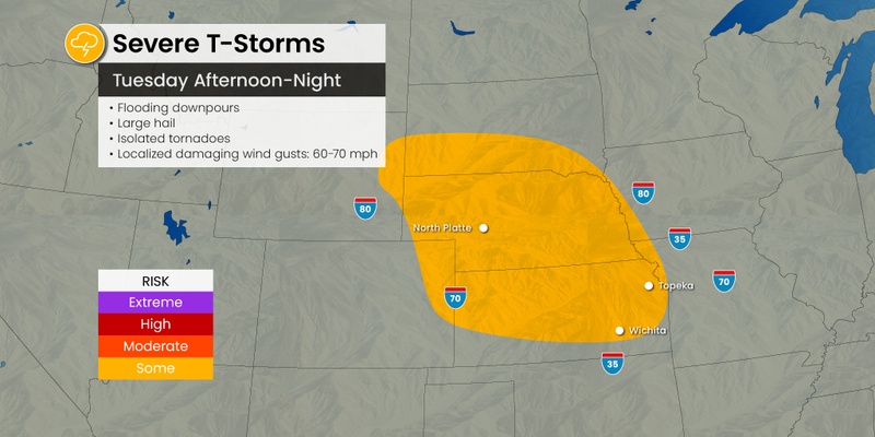
Before the severe weather fires up in the Plains, the Front Range portion of the Rocky Mountains will be at risk of thunderstorm activity on Tuesday afternoon and evening. The eastern half of Colorado and Wyoming will be at the greatest risk of seeing supercells take root later in the day Tuesday, ushering in the chance of large hail, gusty winds, and isolated tornadoes.
Forecasters are predicting that Tuesday night’s storm cells will move to the southeast throughout the overnight hours, coming together with other storms already in place and forming larger complexes. The highest risk of storm activity late Tuesday includes the majority of southern Nebraska and northern Kansas.
The severe weather will once again be an issue on Wednesday for the central U.S. and across into the Mississippi River Valley. The biggest concern for Wednesday will be heavy rain that will elevate the chances of flooding. Cities under the gun for a stormy Wednesday include St. Louis, Nashville, Memphis, and Louisville.
The rain will help to erase some of the drought conditions that have plagued a large part of the central U.S. stretching from the northern Plains of the Dakotas through Missouri.
According to the last report from the U.S. Drought Monitor, many of these areas are still under the designation of moderate to extreme drought. A few localized pockets are under the designation of an exceptional drought.
The rain is welcome news for farmers and their late-season crops. However, too much moisture too quickly can overwhelm the saturated grounds and create runoff and flooding concerns. It will not take much rain for some area streams to overflow in the coming days.
By Thursday, the flooding rainfall risks will move into the Ohio and Tennessee valleys, encompassing parts of Kentucky and Tennessee. Some portions of the Carolinas and Virginia may also get in on this complex of storm cells as the energy ramps up in this part of the country.
A surge of moisture coming up from the Gulf of Mexico will collide with this energy to trigger an unsettled weather pattern across the Southeast.
Did you find this content useful? Feel free to bookmark or to post to your timeline for reference later.

January 21, 2024

January 19, 2024

January 18, 2024
