Heavy Rain, Flooding, and Chance of Severe Weather Staring Down the Southern U.S.
January 22, 2024
Posted: February 25, 2023 10:56 am


Parts of the East Coast are not out of the woods yet as it relates to wintry weather. A series of weak winter storms are setting up to push through the region in the coming days to bring the month of February to a close. Here is what you need to know about the upcoming forecast.
A push of much colder air on the back end of the week’s monster storm will be enough to freeze over the snow and ice that may have melted on Friday. This will bring the chance of icy roads to parts of Interstate 80, across the Southern Tier Expressway in New York state, and along some parts of Interstate 84 in the northeastern corner of Pennsylvania and into the lower Hudson Valley.
You can expect the mercury to dip below zero in the northern tier of New England on Saturday morning. Readings will hover in the single digits and teens across southern New England and into the central Appalachians. It will be slightly warmer along much of the Interstate 95 corridor south of New York City with lows in the 20s and 30.
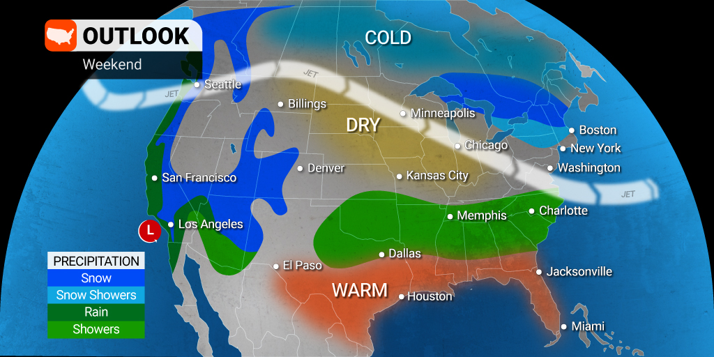
The rush of colder temperatures will put in place the chance of wintry precipitation for a large part of the mid-Atlantic over the weekend. Light snow and scattered flurries are in the forecast for New England on Saturday. Another separate storm will usher in rain and cold drizzle to the Southeast. The temperature will be cold enough in the mid-Atlantic for a wintry mix to develop to start the weekend. The areas most likely to see this wintry precipitation include West Virginia, northern Virginia, Delaware, and Maryland.
Those living along the Interstate 95 corridor for New York City to Washington, D.C. may see a few snow showers out of this weather maker. However, temperatures hovering above freezing will make it less likely that any snow sticks to paved surfaces. Snowfall is trending well below historical averages in this part of the country this year with the chances of any significant snowfall dwindling as the calendar gets ready to flip to March.
Yet another weak weather maker will gear up in northern New England on Sunday afternoon. This system will bring a chance of a few new inches of accumulation to portions of Maine, New Hampshire, and Vermont by the end of the weekend.
Heading into next week, a more robust storm system is on tap after it slams through Southern California this weekend. This system will make its way to the northeast in the coming days, eventually landing on the East Coast by late Monday or early Tuesday. Forecasters are warning that this could be the most impactful storm of the season for central New England, including the Boston metropolitan area.
Boston could see up to a foot of snow out of this system should it find the moisture and energy that it needs to continue to develop. It is looking to primarily be just rain that falls in Washington, D.C. and Philadelphia. Forecasters are still uncertain about the moisture that may fall across New York City. There is a chance that the Big Apple might see a wintry mix by Tuesday morning.
This same cross-country storm system will usher in rain to much of the Midwest. For instance, cities such as Chicago, Des Moines, and Detroit may see a good amount of rain out of the system, resulting in travel disruptions and other headaches. Fog may also be an issue for many areas of the Midwest, creating more difficulties for air travelers.
Severe thunderstorms could be the story in the central and southern Plains as well as the Mississippi Valley beginning late Sunday and continuing through Monday. Farther north, Minneapolis will see either rain or a wintry mix on Monday, depending on how low the temperature falls. Another round of snow is in the cards for the middle of the week for the Twin Cities.
Looking even further ahead, another storm system is forecast to push through by the end of next week. While the details are still preliminary, this storm system will likely bring wintry precipitation to those in the northern half of the U.S. with severe storms popping up in the South. The bottom line is that it does not appear as if winter is ready to let go in the Midwest and the Northeast yet.
Did you find this content useful? Feel free to bookmark or to post to your timeline for reference later.

January 21, 2024

January 19, 2024

January 18, 2024