
Heavy Rain, Flooding, and Chance of Severe Weather Staring Down the Southern U.S.
January 22, 2024
Posted: September 5, 2023 3:00 pm


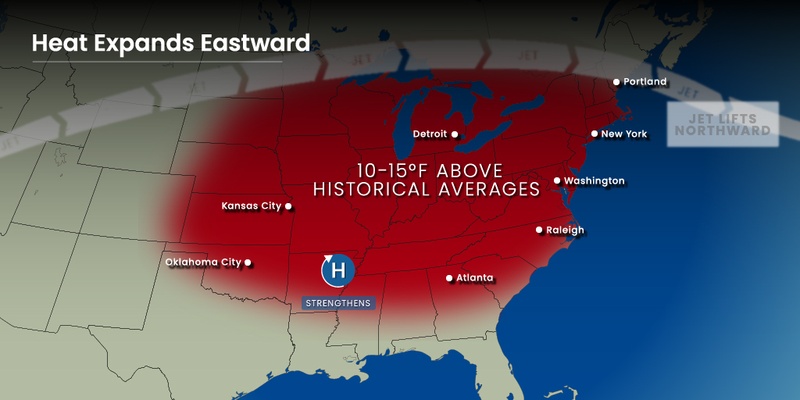
The calendar may be reading September but it is feeling more like late July and early August through the Northeast and the mid-Atlantic. Temperatures are forecast to linger in the 90s for much of the region through at least the middle of the week, translating to some of the warmest readings of the season. Here is a look at when you can expect this heat to break.
The surge of early September heat may be catching many residents of the East Coast by surprise. The mercury is predicted to continue to climb as Americanas return back to work and school after the long holiday weekend. The unseasonably warm temperatures are being blamed on a large zone of high pressure anchored over the Southeast.
Some communities in the mid-Atlantic may see readings eclipse the century mark this week. The Northeast is expecting widespread temperatures in the 90s through at least Wednesday. The readings may be enough to bring down daily high records that have stood for years.
For instance, Philadelphia is bracing for the mercury to soar to about 95 degrees on Tuesday before inching up to about 97 degrees on both Wednesday and Thursday. The top reading so far this summer for the City of Brotherly Love has been 95 degrees, a benchmark reached only twice this season. This means that the hottest weather of the summer for the city could take place well into September.
This is typically the time of the year when residents can begin to anticipate the arrival of fall. The temperature this week will average about 10 to 15 degrees warmer than is normal for a large swath of the East Coast, stretching from interior New England and down into the mid-Atlantic.
It is rare for many of these communities to see temperatures linger in the 90s after September rolls around. You have to go back to 2018 to find temperatures that landed over 90 degrees for many cities in the interior Northeast. A rare September heat wave this year brought down a number of high temperature records with states such as West Virginia, Delaware, and Maryland notching the hottest September in recorded history.
Washington, D.C. may be one of the cities that climbs into the triple digits this week. The nation’s capital has not seen this threshold at all this summer. The best odds for seeing readings hit the 100-degree mark will be on Tuesday or Wednesday.
The lingering summer heat will also worsen the drought conditions in some parts of the region. Northern and western Virginia, the western edge of Maryland, and south-central Pennsylvania are currently experiencing some of the driest conditions in the country with rainfall amounts running well below the normal range for this time of the year.
Some communities in this part of the mid-Atlantic and the interior Northeast only recorded 10% to 20% of their typical rainfall for August. This lack of moisture has sent some areas into the category of a moderate drought as defined by the U.S. Drought Monitor.
This parched soil supports the development of hotter air above the surface of the ground, meaning that it will feel even warmer than the mercury actually indicates this week. The surge of humidity coming up from the Southeast will also raise the real feel readings.
Relief from the heat will start to arrive in the interior portions of the Northeast beginning Thursday. It may take a bit longer for the relief to hit areas closer to the coast, including Philadelphia and New York City. For instance, Philadelphia will not drop below the 90-degree mark until Saturday when the forecast is calling for a high of 84 degrees.
The northern and western portions of Pennsylvania and central Ohio will see the temperatures drop by Thursday or Friday. Pittsburgh will enjoy readings in the 70s by the time that the weekend rolls around. Washington, D.C. will experience a steady decline in the temperatures beginning on Friday with readings in the 70s on tap by the beginning of next week.
Lower dew points across the region will also bring down humidity levels. This will translate to more comfortable weather overall.
Thursday will also bring the chance of rain and thunderstorms for parts of the eastern U.S. as the storm system currently setting up across the northern Plains is forecast to move in this direction. While this weather maker will not likely trigger a total washout, you will want to keep abreast on your local forecast if you have outdoor plans in the latter part of the week.
Did you find this content useful? Feel free to bookmark or to post to your timeline for reference later.

January 21, 2024

January 19, 2024

January 18, 2024
