Heavy Rain, Flooding, and Chance of Severe Weather Staring Down the Southern U.S.
January 22, 2024
Posted: June 19, 2023 3:22 pm


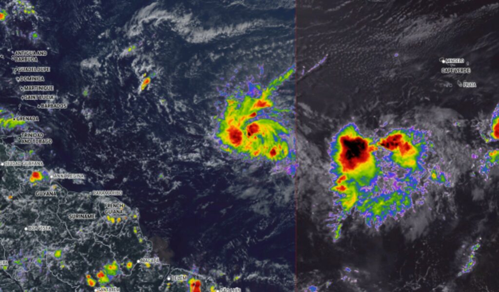
Will a tropical depression form this week in the Atlantic? Forecasters with the National Hurricane Center (NHC) are keeping a close eye on a potential area of development as the tropics heat up. Here is the latest on the tropical weather outlook over the next several days.
The NHC has dubbed the latest area of showers and thunderstorms as Invest 92L. This feature is located several hundred miles from the west coast of Africa. Invest 92L is moving to the west across the Atlantic where it is likely to find unseasonably warm ocean water temperatures once it reaches the central portion of the basin.
The typical threshold for ocean water temperatures to support tropical development is a minimum of 80 degrees. The current readings in the area stretching from the Cabo Verde Islands to the Windward Islands is in the range of 80 to 82 degrees. This is several degrees greater than what is usually seen this time of the year in this corner of the Atlantic.
The absence of the dust that emits off the Sahara Desert in Africa has encouraged the sun to heat the waters of the Atlantic at a faster and more intense pace. This has supported the development of potential tropical weather events when compared to years when more of this dust is in place.
Forecasters are still uncertain about how much wind shear this budding tropical feature will find as it makes its way to the west across the Atlantic this week. As of late Sunday, the cluster of storms was spinning in an area of low wind shear, creating favorable conditions for more development.
However, the amount of wind shear is forecast to increase as the feature moves closer to the Leeward Islands, potentially mitigating further intensification. More wind shear will break up tropical development as it tears apart the various layers of the storm rising into the upper levels of the atmosphere.

The current model indicates that the rainstorm will continue to strengthen, possibly reaching the status of an official tropical depression by the middle of the week when it arrives in the central Atlantic Ocean. This path would put it near the northeastern corner of the Caribbean Sea by the end of the week and heading into the weekend.
Shipping interests in this part of the Atlantic will want to keep an eye on this feature. The next name on the list of storms in the Atlantic basin this season is Bret.
The Lesser Antilles may see the impacts of this rainstorm by the weekend as it continues to move to the west and northwest. Possible impacts include strong winds and heavy rain. Gusts may approach 60 mph as it skirts through the northeastern Caribbean. Rainfall amounts are currently projected in the 1 to 2 inch range.
Right on the heels of this feature may be another tropical wave originating from Africa. At this time, it is too early to tell what type of tropical characteristics this wave may take on as it moves to the west.
In addition to this activity in the Atlantic, forecasters are monitoring a potential tropical event in the East Pacific Ocean. This feature originated as an area of low pressure off of the coast of southwest Mexico that has generated a large zone of rain showers and thunderstorms.
This disturbance currently has a low chance of strengthening into a named tropical system. Even if it does take on tropical characteristics, it is not likely to impact land.
Did you find this content useful? Feel free to bookmark or to post to your timeline for reference later.

January 21, 2024

January 19, 2024

January 18, 2024