
Heavy Rain, Flooding, and Chance of Severe Weather Staring Down the Southern U.S.
January 22, 2024
Posted: September 16, 2023 8:18 am


What is left of Hurricane Lee is not even in the rearview mirror and forecasters with the National Hurricane Center (NHC) are already watching a new potential development picking up steam off the western coast of Africa. This disturbance is forecast to become the next named storm of the 2023 Atlantic hurricane season. This is what the current forecast models are saying about this feature and what degree of risk it may pose to the Caribbean and the U.S.
Tropical Depression 15 Forms on Friday
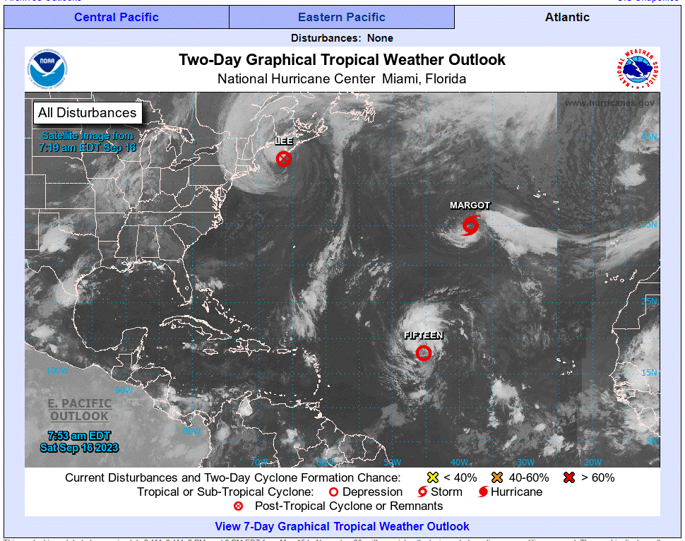
The NHC officially dubbed this latest feature Tropical Depression 15 on Friday. The system could take a similar journey through the Atlantic as its predecessor Lee. Should the feature take on tropical characteristics, it will then be called Nigel.
A path that mirrors Lee would translate to impacts to Bermuda, the Eastern Seaboard of the U.S. and Atlantic Canada. Because it will move through a zone of exceptionally warm waters, there is a good chance that this system could turn into a hurricane as it churns through the central Atlantic in the coming days.
In addition to the ocean water temperatures that have been trending above normal for this time of the year, a low level of wind shear will also provide a supportive environment for further strengthening. These are the same factors that helped Lee to intensify and grow at such a fast clip last week. Lee is now distinguished as the first Category 5 storm in the Atlantic basin this season.
The Leeward Islands will likely dodge this storm as the steering winds over this part of the Atlantic will take the feature away from this area. However, the system will skirt close enough to this group of islands to produce potentially dangerous rip currents and rough surf conditions. The northern edge of the islands may also see some rain from the outer bands of the storm.
Forecasters are confident in their prediction that this storm will continue to intensify due to the available fuel. There is even a chance that this system could become the next Category 5 storm for the Atlantic in 2023.
Although Lee went from a Category 1 storm to a Category 5 monster in just 24 hours last week, this current feature could take its time reaching this threshold. This is because Lee carved a path through the Atlantic that churned up the warmest waters and brought the temperatures down as a result. This process, known as upwelling, works to bring cooler waters to the surface. The cooler water will slow down the development of the new system.
Water temperatures in this part of the basin are running between 80 and 85 degrees. These readings are more than enough to support tropical storm development and growth.
Where is the New Feature Headed?
The latest models demonstrate a good likelihood that this storm could approach the U.S. East Coast by the end of next week. The anticipated position of a high pressure system over the northern portion of the Atlantic will once again steer this storm in this direction.
Forecasters will also be watching the impact that any new cold fronts could have on this budding system. At this point, the storm could fizzle out at sea before impacting the U.S. or it could make a direct strike on the coastline. There is the possibility of a scenario in which a zone of high pressure sets up over the Northeast, bringing the storm closer to the coastline. However, there is also the chance that the high pressure is not strong enough to bring the tropical weather inward. In this case, the storm would remain out to sea before dissipating.
One thing that forecasters are growing more certain of is that Bermuda will once again be in the crosshairs of another tropical event. This group of islands could be the first major landmass to feel the effects from the weather maker. The NHC is warning that Bermuda may see greater impacts with this storm when compared to what the region experienced with Lee.
Hurricane Lee was just a Category 1 storm when it moved near Bermuda earlier in the week. The impacts were minimal because Lee did not make a direct strike. This next storm could track even closer to the archipelago, raising the danger level.
Even if the latest tropical development does not make landfall in the U.S., the entirety of the Atlantic Seaboard could be in for some degree of high waves, rip currents, and more. Stay tuned if your plans in the next week call for a trip to the beach.
Did you find this content useful? Feel free to bookmark or to post to your timeline for reference later.

January 21, 2024

January 19, 2024

January 18, 2024
