Heavy Rain, Flooding, and Chance of Severe Weather Staring Down the Southern U.S.
January 22, 2024
Posted: August 4, 2023 1:49 pm


The Northeast will see a nice stretch of weather in between two rounds of storms over the next few days. Here is what you need to know when planning outdoor activities in this corner of the country.
The pleasant weekend in the Northeast will be bookended by two rounds of potentially dangerous weather impacts, including flash flooding and gusty winds. The first round of severe weather will get going later in the day Friday. Although it has been a dry start to the month of August for this part of the U.S., that will change on Friday afternoon and evening as high humidity levels set the base for storms to ignite.
Some residents in the Northeast may see a rocky commute home for the weekend as the storm activity gets going. The busy Interstate 95 corridor will be ground zero for the heavy rain, hail, and strong winds. Be sure to take caution if headed out for a road trip for the weekend along this heavily traveled stretch of highway.
Just as these storms are firing up, a mass of dry air coming in from the west will end the activity happening along the Great Lakes. The greatest risk of severe weather on Friday afternoon and evening will extend from north-central portions of Pennsylvania and up through southern Vermont.
The good news is that this part of the interior Northeast has enjoyed several days of dry weather, meaning that the grounds are not overly saturated. This will translate to a lower risk of flash flooding. However, some areas of eastern New York and up through Vermont and New Hampshire could be at risk of small stream flooding.
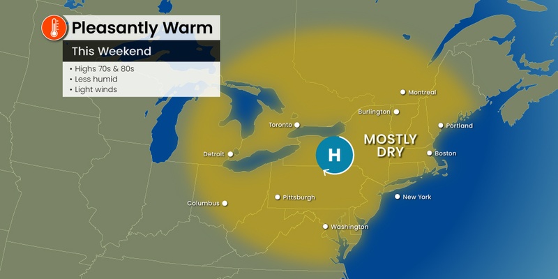
Friday’s severe weather will clear out and make way for a pleasant Saturday. Cooler air coming down from Canada will bring temperatures that feel more like the start of fall for the Northeast. Overnight lows will also fall into the 60s across the cities along the Interstate 95 corridor and into the 50s for the higher terrains.
The daytime high readings in New York City will top out in the upper 80s on Saturday with Boston struggling to climb out of the upper 70s. These temperatures will hover about 5 degrees below average for the first weekend of August.
The mercury will inch up a few more degrees by Sunday afternoon, however, another change is on the way to start the work week.

Forecasters are warning that another and more stronger round of storms is on the horizon for the Northeast on Monday. Millions of Americans will be in the impact zone of Monday’s storm activity as an atypically potent August weather maker sets up over the region.
Rising humidity levels will be the first sign of trouble. The storms will initially impact portions of the Midwest on Sunday, including the major cities of Chicago and Detroit. Both of these metro areas could experience a rough end to the weekend, particularly for travelers looking to return home for the start of the new week.
These storm cells will carry the usual risks of torrential rain, flash flooding, large hail, strong winds, and isolated tornadoes. Monday’s threats will extend through much of New York State, central Pennsylvania, western Maryland, the eastern edge of West Virginia, and the northwestern corner of Virginia.
The eastern Great Lakes may also see some of these impacts on Monday. In addition, it is possible that the line of storms could extend as far north as southern New England and as far south as the mid-Atlantic. Be sure to check in with the forecast as the new week approaches to ascertain the potential impact to your area.
Forecasters are predicting that Monday’s severe weather threats will be more dangerous and more widespread than Friday’s storm system.
Looking ahead to the rest of the week, you can expect sporadic rain showers and thunderstorms for much of the East Coast as an unsettled weather pattern overtakes the region. Kids heading back to school or families finishing up summer vacation plans may be dodging rain showers and more throughout the week.
Did you find this content useful? Feel free to bookmark or to post to your timeline for reference later.

January 21, 2024

January 19, 2024

January 18, 2024