
Heavy Rain, Flooding, and Chance of Severe Weather Staring Down the Southern U.S.
January 22, 2024
Posted: October 19, 2023 1:53 pm


The mid-Atlantic, the Northeast, and New England are all bracing for a powerful nor’easter this weekend. In addition to the immense moisture and gusty winds, the influx of cold air will also make snow a possibility in some areas. Here is how this forecast for another messy weekend is shaping up.
Nor’easter Forecast to Slam Into East Coast This Weekend
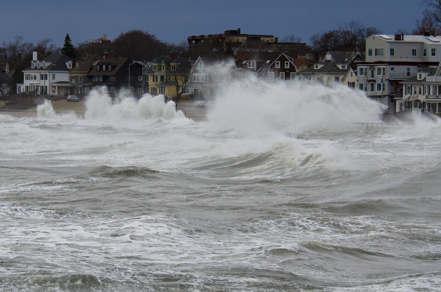
The Northeast and beyond cannot catch a break when it comes to miserable weekend weather. This time around, it will be a powerful nor’easter that is taking aim at the region. While the primary impacts will be felt in New England and to the north in Atlantic Canada, the far-reaching storm will be big enough to impact portions of the Northeast and the mid-Atlantic at times.
The impetus for this weather maker is a storm system that is coming in from the Midwest. This system is predicted to move to the southeast on Wednesday, intensifying with more energy and moisture as it nears the Atlantic coastline. As this storm system hits the Appalachians, it is expected to bring up moisture from the Gulf of Mexico and the Atlantic Ocean.
The energy from this storm system will then lay the groundwork for a new storm development to start the weekend. It is this second storm that is forecast to transition into a nor’easter as it moves to the north along the Eastern Seaboard throughout the weekend.
Unfortunately for the drought-stricken central U.S., the original storm will not be packing enough moisture to alleviate the persistent dry conditions. The only area expected to see meaningful rainfall will be the western slope of the Appalachians and the Ohio Valley.
However, it will be a different story for moisture on the other side of the Appalachians and across to the mid-Atlantic coast. This part of the eastern U.S. is expecting widespread rainfall amounts of 1 – 2 inches at the hands of the nor’easter. A large swath of New England is bracing for rainfall that hits 3 – 4 inches beginning Friday and lasting through late Sunday.
Another Weekend Washout Likely
Assuming the forecast is right and New York City is hit with more rain, it will be the seventh straight weekend that the Big Apple has seen some degree of moisture on at least one of the days. Looking ahead to this storm, the city will see the greatest influx of precipitation on Friday and Saturday.
Areas located to the south of New York City, including Philadelphia and Washington, D.C., will see lighter rain showers. Friday will be the wettest day with gradually drier conditions as the weekend progresses as a mass of dry air moves up from the southwest. The mid-Atlantic may even see some sunshine by Sunday.
Heading to the north, late Friday through Saturday night will bring the greatest amount of rain. While the rain will begin to clear out on Sunday throughout New England, high winds will still make for a miserable time to be outside.
Cold Air Will Support Snow Development
This is the time of the year when the air temperatures drop to levels that can support the development of snow. While lower elevations will miss out on the white stuff, the cold air coming in behind the storm system could change some of the rain into snow across the higher terrains of the Adirondack, the Catskill, the Berkshire, and the Green mountain ranges. This snow will also likely develop in southeastern Ontario and in the southwestern portion of Quebec in Canada.
The winds associated with the nor’easter will average about 15 – 30 mph with the top gusts reaching as high as 50 mph. The highest winds are forecast for Sunday in the Northeast.
Tumbling Temperatures on Sunday
Despite the moisture beginning to lighten up on Sunday, the weather will still feel blustery thanks to the winds and the falling temperatures. High temperatures to close out the weekend will drop as low as the mid 40s in the Appalachians. Moving to the coastline, the Chesapeake Bay will top out in the low 60s for afternoon highs.
The presence of gusty winds will bring the real feel readings down about 20 degrees lower than the actual air temperature. This means it could feel as cold as 30 degrees in cities such as Cleveland.
Those tired of the rain will be glad to see a forecast of drier weather starting early next week. However, the clear conditions will also translate to cold nights. This means that some areas of the Ohio Valley and beyond could experience the first frost or freeze of the season by the time next week is over. This stretch of dry weather could linger through the last weekend of October, finally giving residents the opportunity to get outside and enjoy some classic fall activities such as pumpkin picking.
Did you find this content useful? Feel free to bookmark or to post to your timeline for reference later.

January 21, 2024

January 19, 2024

January 18, 2024
