
Heavy Rain, Flooding, and Chance of Severe Weather Staring Down the Southern U.S.
January 22, 2024
Posted: October 5, 2023 8:45 am


After weeks of roaming through the Atlantic basin, Tropical Storm Philippe is still threatening to bring impacts to land in its path. Here is the latest on this tropical feature.
Northeastern Caribbean Currently Experiencing Wrath of Philippe
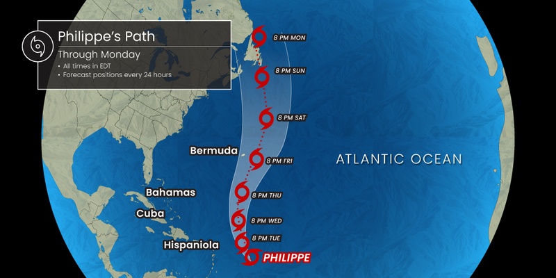
Tropical Storm Philippe is forecast to travel an additional 2,000 miles before it dissipates. While it is impossible to predict with certainty what areas can expect impacts from Philippe in the coming days, the current models indicate that the eastern Caribbean, Bermuda, and Atlantic Canada could see the effects of this storm. There is also the chance that Philippe could make a landfall in the northern portion of New England if the atmospheric conditions line up to steer it in this direction.
Philippe is currently moving to the west, sending heavy rain to the Leeward and northern Windward islands. This part of the northeastern Caribbean is forecast to see 2 – 4 inches of rain out of this tropical storm with higher amounts on a localized level. For instance, as of early Tuesday, over 6 inches of rain had already been recorded at Bird International Airport in Antigua and Barbuda. Over 3 inches of rain had been recorded at St. Lucia’s Hewanorra International Airport.
There is still the chance of these islands seeing impacts such as flash flooding and mudslides as the outer bands push through. The hilly terrain of these Caribbean islands raise the risk of these events.
Steering breezes are forecast to turn Philippe the north in the coming days and into the weekend. The rain associated with the feature will move to the west, putting the U.S. Virgin and British Islands at risk of significant moisture by the middle of the week.
Philippe has encountered notable amounts of wind shear on its journey, serving to keep it at the strength of a tropical storm instead of a hurricane. However, this wind shear is expected to lessen this week, allowing more thunderstorms to fire up around the eye of the storm. This increase in thunderstorm activity within the heart of the storm could create some degree of intensification as the feature moves out of the Caribbean and closer to Bermuda.
What Bermuda Can Expect From Philippe
Bermuda could still see a direct strike from Philippe depending on its track. This track will be determined by the steering breezes over this part of the west-central Atlantic when Philippe inches closer.
Bermuda should not have difficulties weathering this storm thanks to its strict building codes. Even if Philippe is able to strengthen into a Category 1 hurricane, the group of islands will likely just see heavy rain and strong winds. Rough sea conditions will likely put a damper on beach and water activities for tourists.
Impacts to North America?
There are still a number of ways that Philippe could unfold as it approaches the East Coast and Atlantic Canada this weekend. The most likely scenario is that Philippe continues its path to the north, putting the area near the border of New Brunswick and Maine as the most likely location for a landfall. The likely time frame for a landfall in this location would be late Sunday and into Monday.
The data also suggests that Philippe would pass over the southern tip of Nova Scotia on this journey. Should it hit Atlantic Canada, Nova Scotia is most likely to see the brunt of the impacts. There is also the possibility that Philippe could take a turn to the southeast when it reaches this part of the basin, joining forces with a cold front and a non-tropical weather system to create heavy rain for the Northeast, New England, and into Maritime Canada.
The cooler ocean waters swirling near New England and Canada will work to weaken Philippe. This means that the storm could transition into a non-tropical event before moving over land. Despite an anticipated weakening, residents of Maine, Nova Scotia, Prince Edward Island, and New Brunswick should pay close attention to the development of this storm as it will still bring the good possibility of significant impacts.
This is the same part of Atlantic Canada that took the worst punch from what had been Hurricane Lee in the middle of September. Like Lee, potential impacts from Philippe include flooded roadways, power outages, and mudslides.
The arrival of Philippe could coincide with another deluge of heavy rain anticipated in the Northeast beginning Friday night and lasting through the weekend. While this moisture will not likely rival what the region saw last week to start the weekend, it is predicted to be enough to impact travel and wash out some outdoor plans for this part of the country.
Forecasters have noted that there is space for a plume of tropical moisture to develop and push across the Northeast. This surge of moisture would most likely dodge New York City. However, Boston, Providence, and Portland could see the impacts of this heavy rain in the form of flash flooding and disruptions to travel.
Did you find this content useful? Feel free to bookmark or to post to your timeline for reference later.

January 21, 2024

January 19, 2024

January 18, 2024
