Heavy Rain, Flooding, and Chance of Severe Weather Staring Down the Southern U.S.
January 22, 2024
Posted: August 20, 2023 7:04 am


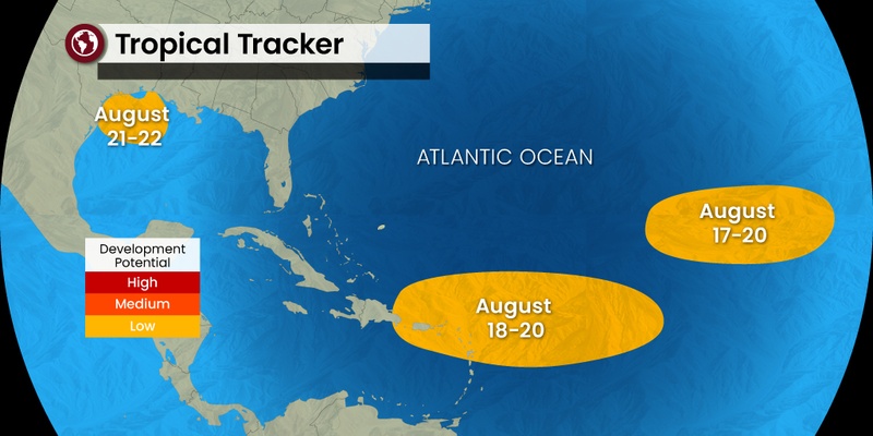
Just as Hurricane Hilary barrels toward Southern California, the Atlantic basin is also starting to come to life. Forecasters are watching five potential areas of development in this part of the ocean as the Atlantic hurricane season begins to reach what is typically the peak time of activity. Here is the latest on what experts are monitoring.
It has been a lengthy period of quiet across the Atlantic, however, that looks like it is about to change in the coming days. The lull across the Atlantic has been in direct contrast to the East Pacific, a part of the tropics that has seen three named storms form over the last few weeks. This includes the formation of Hurricane Hilary, now predicted to track into Southern California by the end of the weekend.
The National Hurricane Center (NHC) is warning that an area of tropical downpours could impact a large portion of the U.S., stretching from Florida and into Texas by next week. This area of likely tropical development will usher in rip currents along the coast of the Gulf of Mexico.
The silver lining is that this feature is also forecast to deliver much-needed rain to a part of the Gulf Coast that is in need of the moisture. According to the U.S. Drought Monitor, a part of the western coast of Florida is under the categorization of moderate to severe drought.
The great chance of tropical impacts to the Gulf Coast will be starting early next week. Texas could see this rain arrive by the middle of the week as the disturbance is forecast to move to the west. The exceptionally warm waters circulating in the Gulf of Mexico will aid in the development of this feature.
Even if the disturbance does not take on tropical characteristics, it is likely to bring a good amount of rain to Texas on Tuesday and Wednesday. This rain will come as a great relief to the Lone Star State as it has been grappling with extreme heat and dryness over the last several weeks.
For instance, Houston has not recorded any measurable rain since July 6. In addition, the daily high in the city has not been out of the triple digits since July 30. This hot and dry weather has been the result of a stubborn heat dome that has been parked over the southern Plains for most of the summer. A shift to the northeast of this area of high pressure will make it possible for some tropical moisture to creep into the region.
The Gulf of Mexico is not the only part of the Atlantic that may see tropical development heading into next week. Another area of potential development is raising concern to the west of the Cabo Verde Islands deep in the Atlantic. A broad area of circulation is partnering with widespread showers and thunderstorms as it moves to the northwest into much warmer water temperatures.
The current models do not indicate that this system will impact any land. The next name up on the list of Atlantic storm designations is Emily. Following Emily, the names are Franklin, Gert, and Harold.
The central Atlantic is also starting to sport some tropical activity. A zone from the Caribbean islands into the central Atlantic Ocean has been pinpointed by the NHC as seeing a medium risk of development this weekend and into next week. There are a handful of disturbances within this zone that could sprout to life and turn into a named storm. Any of these disturbances could move closer to the Lesser Antilles by the end of the weekend, bringing heavy rain and strong winds to these islands.
Forecasters are warning that another disturbance is expected to come off the coast of Western Africa later next week. This system is emerging just as the tropics generally begin to see a surge of activity. The climatological peak of the Atlantic hurricane season is September 10 with an official end date of November 30.
Although it has been a slow start to the first half of the season, hurricane experts still predict that the year will end up with an above average number of named storms in this basin. There have only been four named storms thus far this year with most experts predicting that the season will end up with between 13 and 17 features. The historical average number of named storms is 14.
Did you find this content useful? Feel free to bookmark or to post to your timeline for reference later.

January 21, 2024

January 19, 2024

January 18, 2024